View count:
5036
Non Nuoc Cao Bang UNESCO Global Geopark
1. Introduction
Cao Bang Geopark (also known as Non Nuoc Cao Bang UNESCO global geopark) (UGGp), founded on 22nd December 2015, includes 9 districts (Ha Quang, Hoa An, Nguyen Binh, Tra Linh, Quang Uyen, Trung Khanh, Ha Lang, Phuc Hoa and Thach An) with a total area of 3,072 km2. The geopark contains 130 unique heritage sites; some of them are ranked by the prestigious scientific magazines to have international significances[1].Approximately 250,000 people live in Non nuoc Cao Bang UNESCO Global Geopark, 92% of which belong to one of nine ethnic groups. The area is famous for its diversified ethnic cultural identity with outstanding traditions among ethnic groups, involving festivals, traditional crafts and folk arts. Regarded as a ‘Holy land’, it has been home to prehistoric people more than 20,000 years ago and used to be the capital of some feudal dynasties. In present history, it has become the cradle of Viet Nam’s revolution.
Non nuoc Cao Bang UNESCO Global Geopark offers numerous outstanding historical and archaeological sites, and a rich cultural heritage of national and international significance, lending the Non nuoc Cao Bang area prominence in Viet Nam and providing a strong basis for the tourism industry as it attracts large numbers of domestic and international visitors. In addition, numerous international and national geosites, such as fossil sites, geological boundaries, mineral deposits and intrusive, volcanic and sedimentary rocks are well preserved. The geological heritage and biodiversity resulting from unique natural and geographical conditions has shaped the unique culture of Non nuoc Cao Bang, revealed in the diverse cuisine, traditional costumes, rituals and way of living.
Non nuoc Cao Bang UNESCO Global Geopark and communities have long set a strategy for sustainable socio-economic development, nature conservation and environmental protection, a holistic approach to heritage values, while promoting geo-tourism and related services. To ensure active and comprehensive local participation, the development plans of Non nuoc Cao Bang UNESCO Global Geopark focus particularly on stakeholder promotion, education and awareness raising. Due to its complex geology and diversified mineral resources, the area has long received considerable research interest[3].
2. Location
Located in the northern and eastern districts of Cao Bang Province in Northeast Viet Nam, Non nuoc Cao Bang UNESCO Global Geopark covers a total area of 3,000 km2. Mountainous landforms cover approximately 90% of the land area, with elevations ranging from 1,500 to 2,000 m in the west-northwest to 200 m in the east-southeast. With a highland tropical monsoon climate and two distinct wet and dry seasons, the Geopark exhibits a rich biodiversity, with widespread forests, endemic faunas and floras, herbs, specialty crops etc. The region has a complex drainage network that includes 5 major river systems and 47 lakes.
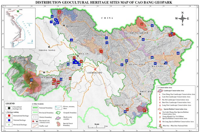
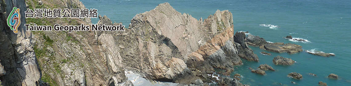
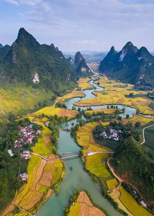
Non nuoc Cao Bang UNESCO Global Geopark is divided into two distinctive parts by the Cao Bang-Tien Yen deep-seated active fault. The eastern part of the Geopark is mostly composed of limestone. This demonstrates a complete tropical karst evolution cycle with various classic landforms e.g. peak-cluster depressions, cones and towers, old and active caves with magnificent speleothems, closed and interconnected valleys, underground and surface rivers including a ‘turlough’ lake system, and one of the world’s largest waterfalls located on an international border. The western part features sedimentary rocks, pillow basalts, ultra-mafic and granitic intrusions rich in minerals and hydrothermal alterations. The area also reveals sedimentary rocks dating back more than 500 million years, with stratotype cross-sections, and fossils indicating different paleo-environments and biosphere extinction events. The diversity in rocks (stratigraphy, paleontology, paleoenvironment, petrology, mineralogy etc.) and landforms (tectonics, geomorphology, karst, weathering, soil erosion etc.) are evidence of the geodiversity of the area, each with its own characteristic of different evolutionary stages of the Earth’s crust.[4]
3. Management[1]
Non Nuoc Cao Bang UNESCO global geopark (UGGp), founded on 22nd December 2015. Since its establishment, the Management board of Non nuoc Cao Bang has received lots of support from the Party Committee, People’s council, People’s committee, and the Steering committee as well as active cooperation from Departments and districts in the its development process.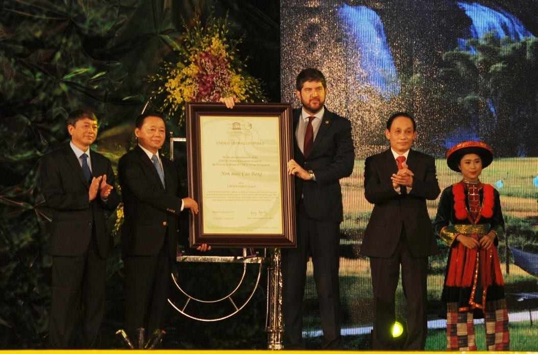
The Ceremony on receiving the UNESCO global geopark lable of Non nuoc Cao Bang.
In 2018, the Management board of Non nuoc Cao Bang UGGp achieved remarkable outputs, especially in the communication for awareness enhancement and promotion area. Specifically, the Board organized successfully the commucation and education sessions for communities on geopark including 5 provincial level courses for 575 turns of public officials, manager and staff working in tourism service sector; cooperated with the Department of Education and training to provide the training of trainer training for 229 teachers at primary, secondary and high school level; organized 04 education and communication courses of more than 437 participants, who are representatives of the office of Cultures and communication, commune officials, youth union, and tourists’ service provider in the district area on global geopark and geological heritages in 4 provinces: Ha Giang, Tra Linh, Nguyen Binh and Hoa An. The Board has issued 4 News letters in 2018, leaflets and guide books of the three experience routes. It also completed the project on updating the UNESCO logo and informational panel system in the geopark. In 2018, the Board also organized the summing up the first Competition on “Best shots of Non nuoc Cao Bang and landscapes in Cao Bang” and launched the second Competition on “Best shots of Non nuoc Cao Bang and landscapes in Cao Bang in 2019”.
In particular, in 2018 the image of Non nuoc Cao Bang geopark once again became widely known through the Ceremony on receiving the UNESCO global geopark title; many representative leaders from Ministries and central agencies, especially the Prime Minister of Viet Nam participated at the event. In addition, in 2018, the Board actively introduced the image of Cao Bang to the world. At the conference of GGN held in Italia, the Cao Bang delegation organized a promotional stand on Non Nuoc Cao Bang geopark, made 02 presentations on the of Non Nuoc Cao Bang, and chaired successfully one Conference session.
The continuation of carrying out the promotion on UENSCO global geopark plays important role the increase the effectiveness of the UNESCO global geopark model, which will contribute positively to the branding of Cao Bang tourism, then the improvement of livelihood of local communities in the geopark area in particular and in Cao Bang in general. It also helps to increase awareness of local communities in the preservation of environment, natural conservation, traditional, cultural, historical values of local communities, and make best use of competive advantages of the province such as ecological, cultural and community-based tourism. Last but not least, it will help to mobilize national and international investment into tourism sector of Cao Bang. To promote and make best use of these advantages of Cao Bang in 2019 and the period 2019-2022, the Management boar of Non nuoc Cao Bang will focus on some of following tasks: Continuing to carry out communication and promotion activities to raise awareness of communities in the geopark area, especially the tourists’ service providers, geopark partners on the importance of the development of UNESCO global geopark in Cao Bang, so that they will actively participate in and support the development of UENSCO global geopark model in Cao Bang. To assist the communication and communication activities, the Management board will develop some IEC material for the promotion of Non nuoc Cao Bang geopark such as: the News letter in 2019, the Leaflets of the Three experience routes; design and the communicational identified images of Non nuoc Cao Bang geopark. In addition, the update of the website and social sites to promote the image of Non nuoc Cao Bang is one of other important activities, in which the Management board will pay more attention to use facebook in branding its values, and develop a feedback collection mechanism to the quality of service provided in the geopark area on TripAdvisor.
The Management board consulted and prepare the signing of Framework contract with the Institute of Geologoy and Mineral resources, and international experts on the development of Non nuoc Cao Bang geopark, including the task on communication and branding of Non nuoc Cao Bang UGGp for the period 2018-2022; agreed on the monthly meeting schedule with the UNSCO expert and UNESCO global geopark network in Viet Nam, and the Institute of Geologoy and Mineral resources To cooeprate wtih Dong Van karst plateau UGGp, Ha Giang, the Institute of Geologoy and Mineral resources to organize the UNESCO global geopark information day in Hanoi to introduce geo-tours of the two UGGps to national and international tour operators. To enhance the education, communication and promotion of UGGp in communities and schools; support to development education tools; and bring students for field studies in geopark areas (with subjects related to the teaching curriculums in schools, etc). To develop field collaborators, and tour guides in heritage sites in geopark area; carry our communication activities for tourists’ service providers in the geopark area; strengthen the geopark partners and complete the set of criteria on mass media; and carry out some initiatives to support livelihood improvement for ethnic groups living in the geopark area. To carry our communication activities on environment and landscapes in the geopark area, especially the heritage sites; develop an M&E system and periodically conduct field inspection for timely action of site protection; to consult the People’s committee to develop plan of Cao Bang to participate in the 6th APGN in Indonesia; to strengthen international cooperation with other UGGps to introduce the images of Cao Bang to the worlds.
Non nuoc Cao Bang is a new UGGp, so the development of the geopark following criteria of UNESCO is still facing certain difficulties, especially the criteria related to the community engagement in the development Non nuoc Cao Bang UGGp. Therefore, to meet this criteria, the communication and promotional activities will play a key role so that communities living in the geopark area can understand the importance for the development of UNESCO global geopark. The advertisement of Non nuoc Cao Bang geopark on mass media will help to the draw attention of visitors to experience Non nuoc Cao Bang UGGp, which then will contribute to the development of tourism sector of Cao Bang province. (Trương Thế Vinh - Deputy Director of Department of Culture, Sports and Tourism - Head of UNESCO Global Geopark Management Board Cao Bang)
4. Landscape
4.1 Karst landscapeThe Phja Oac Panorama
Located in the Western route of Non nuoc Cao Bang geopark-Experience Phja Oac, the mountains of transformation, and in the core zone of Phja Oac-Phja Den National park, the Phja Oac Panorama has an altitude of around 2000m above sea level (asl) with exceptional landscapes and unique climate in the area. The area is rich in biodiversity with well-protected and primitive forest, especially the moss forest system with more than 2000 species of rare fauna and flora, some of which are listed in the red book of Viet Nam.
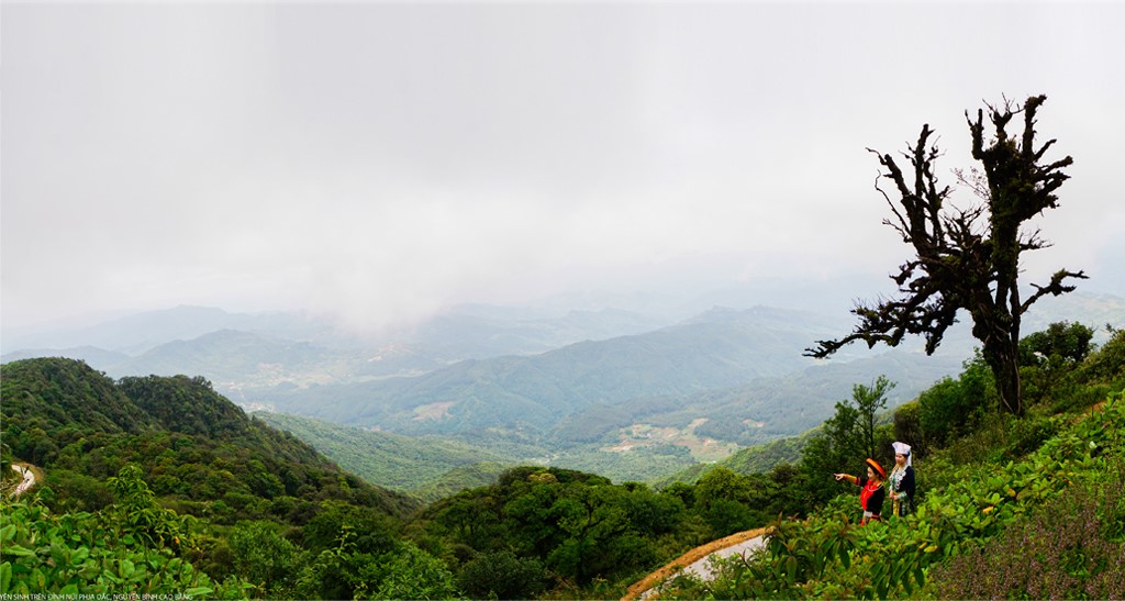
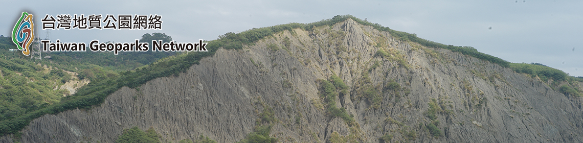
The Phja Oac area has a complex segmented topography characterized by narrow valleys and high and steep mountains with elevation of more than 30 degree, some of area with almost vertical elevation. Many peaks are 1000m to nearly 2000m asl, such as Phja Oac (1935m), which is the second highest mountain in Cao Bang. Geologically, the area is a mixture of limestone, sandstone, shale and granite, which results in karst landscapes mixed with earthy mountains. The diversity of topography, geomorphology and geology together with specific climatic conditions produces characteristic high mountain ecosystems and rich biodiversity of the area.
In the distant past, the area was transformed from an ocean to a continent c.250 million years ago. It witnessed then widespread magmatic activities, with strong but smouldering “flaming mountains” extending deep in the Earth 85-95 million years ago, which caused intensive changes in the surrounding rocks. In the last phases, the gas-rich magma caused even more intensive changes, including the formation of rare and precious minerals. Depending on the composition of the surrounding rocks, different types of minerals were formed, such as tungsten in Ban O and Lung Muoi, tin in Tinh Tuc, and fluorite containing radioactive elements in Binh Duong. Later mountain building resulted in the Phja Oac Mountain with different ranges of sub-climate from the base to the summit. Accordingly, the vegetation is extremely diverse, with multi-layered structure and extensive cover as well as special high-mountain ecosystems such as dwarf and moss forests.
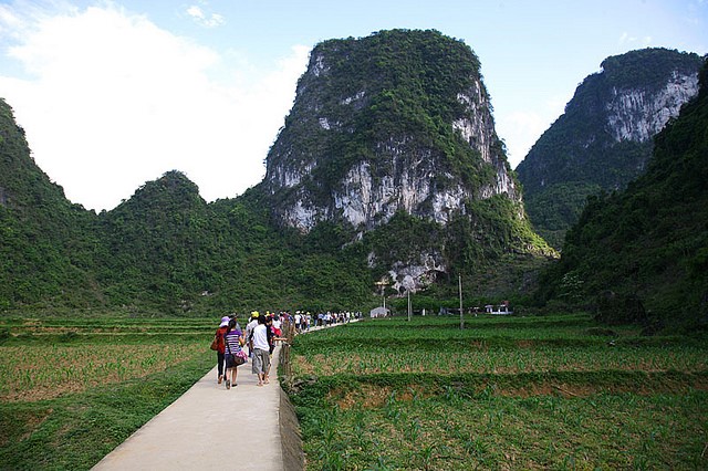
The presence of minerals, the pleasant climate and the beautiful forests were attractive to the French, who occupied this area from the early 20th century and left lots remnants of villas, guest houses and official residences. Phja Oac is also adorned with indigenous ethnic cultures of the Dao, Nung, Tay, Mong people, with vibrant and various colors and themes, expressed in the costumes, beliefs and folks. In addition to the above described cave and lake systems, Cao Bang is famous for mature and old karst landscape with towers rising on large and flat karst fields on open and extended valleys. This landscape can be observed in many locations in the districts of Trung Khanh, Quang Uyen and Phuc Hoa etc. Other mature karst landforms include the same kind of towers that are interleaved with peak clusters-depressions with enlarged floors and the peaks are only connected with each other near the floor. These landforms can be seen in the districts of Ha Quang and Tra Linh as well as other districts mentioned above. In addition, Cao Bang still has an area of young karst landforms in Luc Khu Plateau (Ha Quang). These landforms are mainly composed of peaks connecting with each other near the top to form karst ranges, or karst landforms interleaving with terrigenous landforms as seen in Nguyen Binh and Thong Nong.
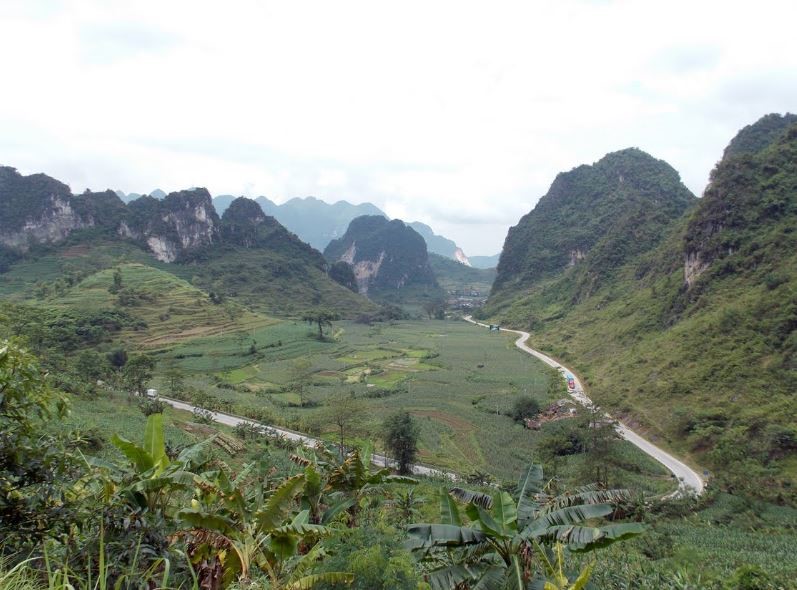
Ma Phuc Mountain Pass with the winding meanders and karst-tectonic topography[1] (Tra Linh)
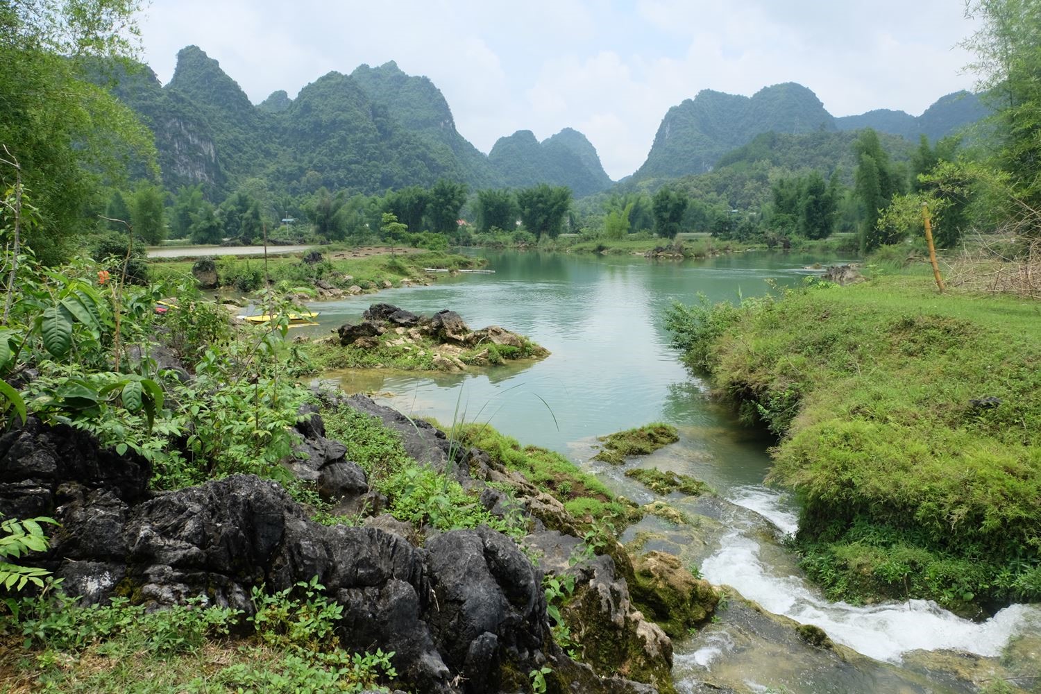
Quay Son River, Trung Khanh, Cao Bang[2]
Karst and tectonic landforms north of Cao Bang-Tien Yen fault
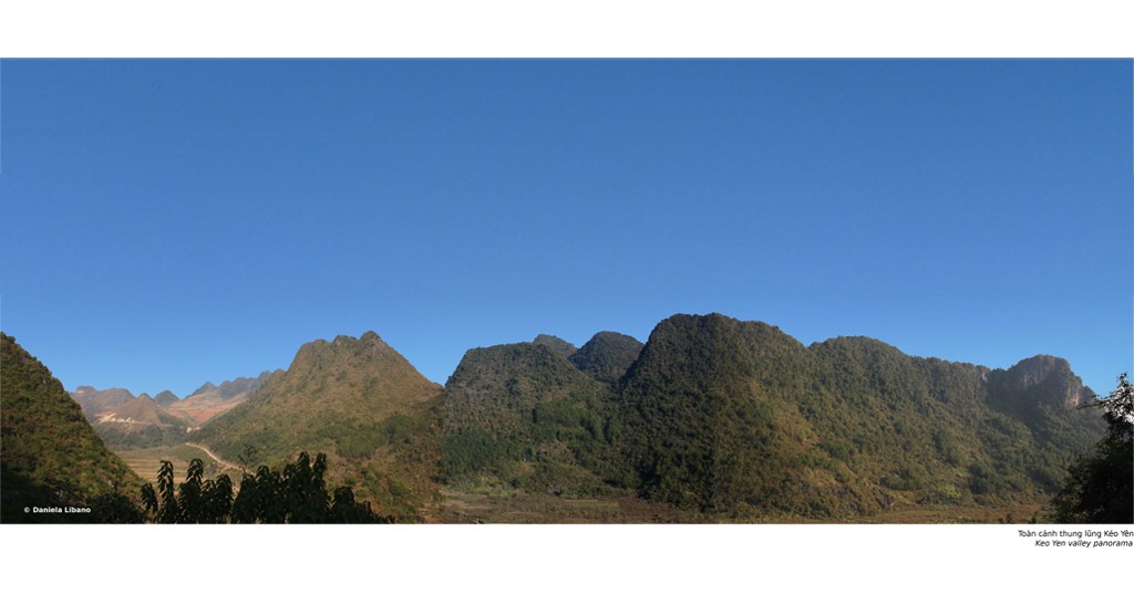
The northern area of Cao Bang Geopark, mainly of Ha Quang district and part of Hoa An and Tra Linh districts, is of Luc Khu massif, another famous karst massif of Northeast Vietnam. The massif’s height descends from 1000m in the northwest to 700m in the southeast, gradually leaning toward a very large karst area east of Ma Phuc pass – the so-called Quang Hoa karst plateau. It is also a karst plateau but compared to the Dong Mu karst plateau, the karst evolution here is in the older phase.
The karst evolution intensifies from northwest to southeast. In the northwest, the main karst landforms are ranges, peak-cluster depressions with cones that surround closed valleys where the vertical erosion process still prevails.
Rain water quickly disappears to underground, so surface water is rather scarce while groundwater is plentiful. To the southeast is the mature and old karst landforms with karst towers, pyramids and cones which have been or nearly separated, surrounding wide valleys; their bottom is quite flat and close to the local erosion level. At this point, the Tra
Linh River connects these valleys to form the Thang Hen “turlough” lake system – a unique scenic spot of Cao Bang Geopark. A number of karst-tectonic heritage features can be observed in the follows:
– Karst landforms showing different stages of karst evolution in Keo Yen commune, Xuan Hoa town, Ha Quang district (X=610200; Y=2533000; z=302m asl);
– The strongly fault-dissected and eroded southern part of Luc Khu karst plateau (Quang Trung, Nguyen Hue communes);
– Young karst landform around Pac Bo cave – a part of the weakly dissected Luc Khu plateau;
– Old karst landform on 700- 1000m planation surface in the south of Pac Bo, in Coc Chu area, Phu Ngoc commune;
– Geological-geomorphological-paleontological heritage cluster in Ha Thon commune, Ha Quang district (X=620000; Y=2523000; Z=677m asl);
– The NW-SE fault slip surface in Lung Dam village, Van Dinh commune (X=612034; Y =2534235; z=721m asl);
– Hanging valley with karst cones on its surface in Soc Giang commune (X=614079; Y=2534763; z=829m asl);
– Expressions of neo-tectonic activity in Dan Chu commune, Hoa An district (coordinates X=609184; Y=2522350; Z=206m asl);
– Traces of river terrace and active caves in Hoang Tung commune, Hoa An district (coordinates X=619422; Y=2509842; Z=195m asl)
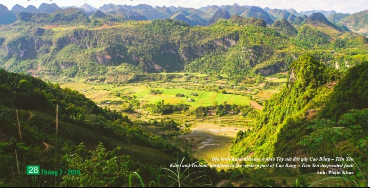
Karst landscapes showing the early, young and mature stages. View from Keo Yen commune[3]
Karst and tectonic landforms west of Cao Bang-Tien Yen fault
The area west of Cao Bang-Tien Yen fault, except for the Cao Bang basin, covers most of Nguyen Binh and Thach An districts. This area exhibits a mix of karst landforms and other denudation-erosion landforms on terrigenous rocks of the Song Hien formation and granites of the Phia Oac complex. The karst landforms are part of the Dong Mu karst massif 1,100-1,300m asl. It forms a plateau between the Nang River and Bang Giang River and has been termed “Binh Lang plateau” by Bourett (1922).
On the relatively flat plateau surface, the terrain is weakly intersected into mountain ranges extending mostly in a NWSE direction separating wide, flatbottomed inter-connected valleys. The area to the west of Cao Bang- Tien Yen fault has been identified as part of overthrust nappes “nappes préyunnanaises” (J. Deprat, 1915, 1917; Lepvrier et al., 2011). At the edge of the massif, the land surface has slipped down to 700- 1,000m, much lower than the ancient planation surface. This has favoured rapid karst evolution creating sharp pyramid-like towers separated widely by flat or undulating valley floors. Hogback topography is also conspicuous with cliffs facing east with piles of rock collapse at their foot, creating stepped erosional terraces of Nguyen Binh River and the so-called “self-covered” karst. In addition to the karst plateau west of the Cao Bang-Tien Yen fault, from Nguyen Binh district towards Thach An district there are large areas of non-karst rocks of the Song Hien terrigenous Formation (T1sh) and the Pia Oac granitic complex (γKpo), forming highly dissected structures. Along Provincial Route No.34 from Nguyen Binh to Cao Bang city, the mountain ranges are more than 1000m high, while to the west and east of Cao Bang city they are only 400-600m and 250-350m high, respectively.
These mountain ranges clearly demonstrate topographical steps which are remnants of planation surfaces at altitudes of 400-600m, 700-1000m and 1100-1300m. Thus, the following geoheritage features can be observed west of Cao Bang-Tien Yen fault in Nguyen Binh and Thach An districts (Annex 6.2.2 for more details):
– Planation surfaces 1100-1300m, 700-1000 and 400-600m asl; – Expressions of overthrust nappes (“nappes préyunnanaises”) with terrigenous rocks of the Song Hien Formation overlying Devonian and Carboniferous-Permian limestones;
– Residual karst landforms of tower and cone forms;
– Mountain divides with pyramid-shape peaks;
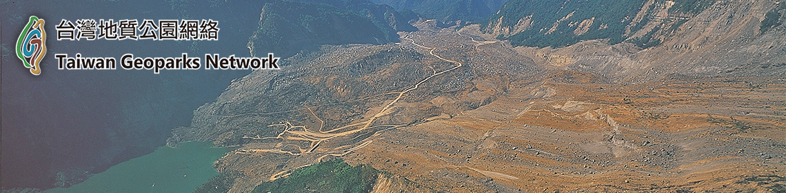
– Tinh Tuc basin, where placer tin ores are mined, and remnant of the ancient bottom of this basin and karst canyon at the eastern end of this basin.
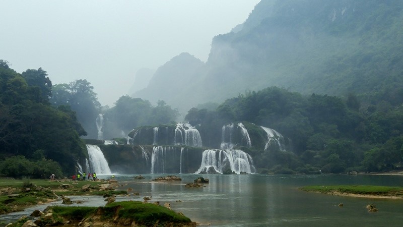
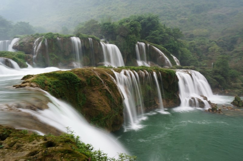
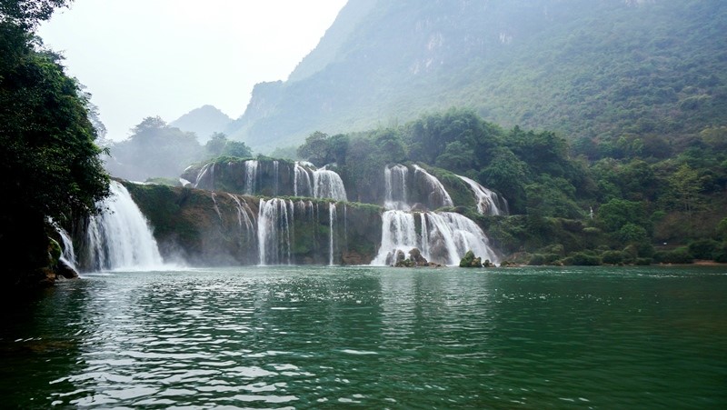
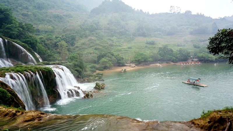
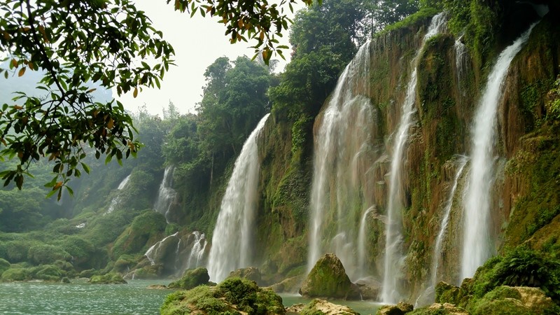
Ban Gioc Waterfall
Ban Gioc Waterfall is located in Dam Thuy Commune, Trung Khanh District. It is known as the fourth world largest and most beautiful waterfall at an international border, after Iguazu at the border between Brazil and Argentina, Victoria at the border between Zambia and Zimbabwe and Niagara at the border between the United States of America and Canada.
Located on Quay Son River which flows in the northwest-southeast direction, Ban Gioc Waterfall is 200m long and about 35m high, separated into 3 floors. The first floor originates from the river and is 14m high, the second floor falls 10m high and 3rd floor falls 6-10m high. It is composed of primary waterfall and secondary waterfall. The secondary waterfall is situated in Vietnam with the length of 150m and only one floor of 30m high. The primary waterfall is located on the border of Vietnam-China, with the length of 50m. Here, a northeast-southwest-directed fault strikes through thin-to-medium-bedded light grey limestone interleaved with thin brown-grey, green-grey clay shale of the Toc Tat Formation (D3tt), which causes the northwest side to uplift and the southeast side to subside, forming this waterfall. Rock beds of Toc Tat Formation strike 220Ð45o. They were sheared and compressed to form boudinages with the size of up to 1cm. The upper part is limestone of Na Quan Formation (D1-2nq), which is dark grey colored, thin to medium-bedded, striking 320Ð45o, and containing Stromatoporoid Amphipora fossil. Surrounding the waterfall is karst landforms with peak clusters-depressions on planation surface at an altitude of 500m, with thick vegetation cover. Quay Son River Fault valley is in northwest-southeast direction with length of kilometers, containing fault cliffs and karst fields.
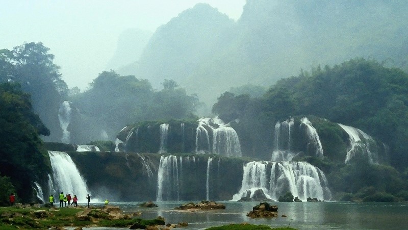
The waterfall measures 35 metres high and spans 300m. Great water columns can be seen from a distance.
The ‘roar’ of the waterfall can be heard kilometres away.
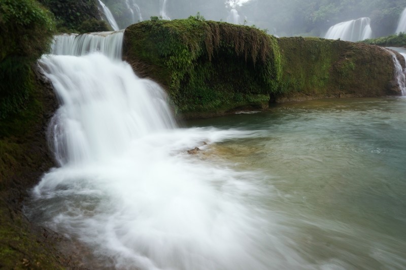
The beautiful enchanted jade-blue water at the foot of the waterfall, surrounded by green from the northeastern jungles.
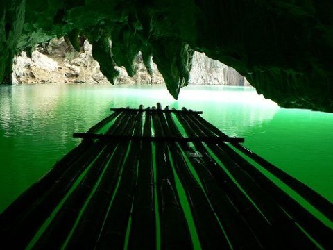
Visitors could take bamboo rafts to approach the cascade for better views.
The water flows also create smaller falls to the left of the central waterfall. (Source vietnamnet.vn)
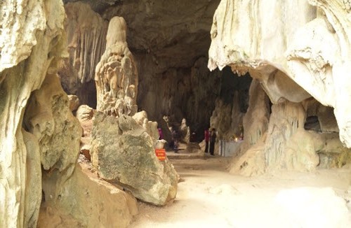
Doi cave
Doi cave (also called Nguom Ca Khao in the local language) is situated in a mountain range which is 700m from public roads in Lung Run village, Dong Loan commune, Ha Lang district. Geographical coordinates X=678817; Y=2516647; entrance elevation: 600m asl. The cave is recognized as a national scenic spot pursuant to Decision No. 622/QD-BVHTTDL of March 10th 2014 of the MOCST.
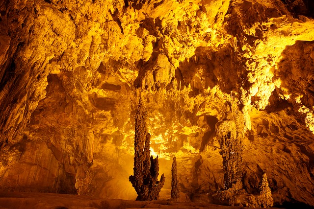
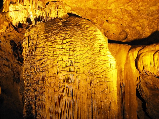
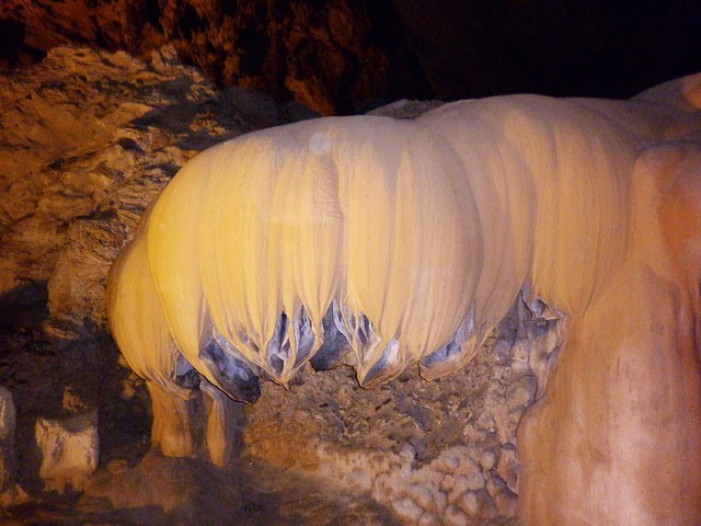
Doi cave is active with a total length of 1,134.1m. The ceiling is up to 40m high, and the chamber is 75m wide. The cave consists of several sections and up to 3 levels, with lots of speleothems e.g. stalagmites, stalactites, columns, rimstones, ponds and lakes of various shapes and sizes, including beautiful rounded accretions called “cave pearls”.
Hang Doi cave can become a major tourist attraction of Cao Bang Geopark in the very near future.
Doi Cave, Cao Bang (http://hanoitimes.vn/doi-cave-in-cao-bang-province-becomes-national-relic-site-13918.html)
Doi cave is formed in 20-25cm-bedded limestone and siliceous limestone of Na Quan formation (D1-D2nq). The cave is oriented NE-SW at the starting section then turns to the NW-SE.
According to VIGMR, Doi cave is active, with a total length of 1,134.1m and a total area of 23,970m2 (excluding sinkholes). The ceiling is up to 40m high, and the chamber is 75m wide. The major sections are as follows:
The entrance section is 65m long and inclined at -16°. The cave floor is rather rough with big avalanche boulders interbedded with stalagmites. The cave wall is covered with many speleothems including rimstone and travertine.
The next section is about 150m long and horizontal. The cave floor is inclined at -5° and divided into 2-3 levels which are 20m apart, forming narrow parallel strips over a length of 50 meters. Beyond this, there are only two levels. The cave is wide with a high ceiling, which creates cool and refreshing feelings. The cave floor is flooded in clear and clean water. Immersed in the water is a variety of carbonate precipitation forms. High above in the second and third levels, stalagmites, rimstone, and travertine lines thrive. At the end of the cave, the second level oversteps the first level with a large travertine array, creating a grandiose and spectacular view.
Doi cave ends with lakes where it expands and turns to NW-SE. The second cave level also extends to form a large upper chamber (Figure, dark-colored part) with many beautiful speleothems – stalagmites, stone pillars, stalactites, and stone terraces. On the first floor, large travertine ponds are found throughout the cave floor, containing many beautiful rounded accretions called “cave pearls” or “Dragon eggs”. In the middle of the large chamber is a sinkhole.
The next section of the cave expands with a collapsed ceiling, and stone columns and avalanche boulders on the cave floor. The cave then narrows back to normal as at the entrance section with a flat floor, many stalagmites, rimstone, travertine lines and cave pearls before ending with a sinkhole about 15m in diameter.
Ky Rang cave
Ky Rang cave within the Thang Hen Lake System was also recognized as a provincial scenic spot in accordance with Decision No. 1325/QD-UBND of September 25th 2012 of the Cao Bang PPC. However, it should be included in the Thang Hen Lake System and the entire system recognized at international level.
Ky Rang cave (Geographical coordinates X=632648; Y=2518455; entrance elevation: 629m asl) is located in Quoc Toan commune, Tra Linh district, about 1.5 km northwest of Thang Hen lake, inside Ky Rang mountain and next to Ky Rang lake. This fossil cave is about 30m from the local corrosion base and is developed in two fault systems in NE-SW and NW-SE directions in limestone of Bac Son formation (C-Pbs). The cave is 417m long, about 34m deep, and 0.7- 30m wide; the ceiling height ranges from 1m to 42m, gradually sloping from the entrance to the exit. It mainly consists of two large chambers separated by narrow and steep entrances. The cave is very clean and airy. The speleothems here are large, beautiful and well preserved.
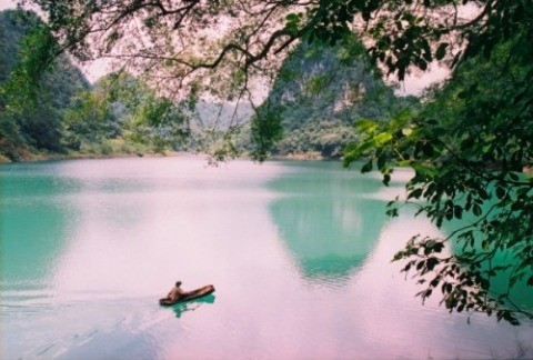
Thang Hen lake
Thang Hen lake was recognized as a national scenic spot according to Decision No. 53/2001/QD-BVHTTDL of December 28th 2001 of the MOCST.
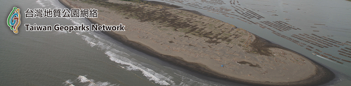
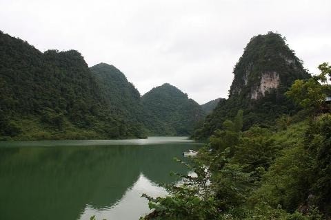
The Thang Hen (bee-tail) lake system has 36 natural lakes, each of which is several hundred meters apart. All the lakes are located in a large valley bordered by Quoc Toan Commune (Tra Linh District) and Ngu Lao Commune (Hoa An District). Thang Hen is the largest lake nearly 2,000m long, 500m wide and 40m deep, surrounded by old forests and karren landforms alternating with rugged cliffs.
The system of Thang Hen Lake and underground river caves are developed in limestone of the Bac Son Formation (C-Pbs), at the intersections of several fault systems. The lakes are located on the valley floor surrounded by peaks connected with each other by low saddles, forming a typical karst peak cluster-depression landscape.
The peaks, at accordant altitudes, are remnants of a planation surface approximately 650m asl., while the valley floors are at an altitude of 550- 600m. The many waterlines show that the lake water level fluctuates about 20m around the 600m level. Some fossil cave floors are found at altitudes of 600-650m, while active caves are at lower altitudes. According to surveys in 2012 by a group of French-Vietnamese speleologists, the underground cave section that is connected with Thang Hen Lake is 820m long and extends to a depth of 54m below the modern surface.
The karst hydrologic characteristics in Thang Hen lake system are very special in which Thang Hen Lake plays an important role, due mostly to the fact that the lakes are inter-connected and there are several cave levels.In addition to the Thang Hen Lake System and the peak-cluster depression landforms, other interesting geological features are found such as fossils (crinoids and fusulinids). Also the flora and fauna here are largely in natural state.
Thang Hen Lake System is among the treasures of the Cao Bang Geopark and of international significance as a geosite.
Thang Hen lake system
(Photos vnexpress)
Nguom Ngao cave
Commonly described as the most beautiful cave in Vietnam, Nguom Ngao cave (Tiger cave in English language) was discovered in 1921 and was developed for tourism in 1996. It is recognized as a national scenic spot according to Decision No.95/QD-BVHTTDL of January 24th 1998 of the MOCST. The cave is located in Gun village, Dam Thuy commune, Trung Khanh district, 5 km from Ban Gioc Waterfall.
Nguom Ngao cave is developed in limestone of the Na Quan formation (D1-D2nq).
The cave has several branches trending in a general NW-SE direction. The surrounding karst terrain is peak cluster-depression located on a planation surface at an altitude of 400-600m, with many hanging valleys and sinkholes. Within the cave are various chambers, floors, steps and lobbies of many sizes. Speoleothems of various forms are abundant, imitating corals, ships, gold and silver cascades, upturned lotus flowers, individual rock pillars and terraced rice fields. An underground stream with gravel deposits several meters thick flows to the Quay Son river. Its echoing sounds, like the roar of tiger, give the cave its name – Nguom Ngao.
Recent survey (2015) shows that Nguom Ngao has an overall length of 2,769.6m and is 61.1m deep, with two floors: one active at stream level and the another dry, about 50m above the stream. The cave has five entrances at an altitude of 420-507m asl. The cave management Board has opened only one section of 945,8m with two entrances for tourism but there is a plan to expand this in future.
Alongside Nguom Ngao cave is the Ban Thuon cave, which is located at Phia Pang mountain, Ban Thuon village, Dam Thuy commune. It was recognized as a provincial scenic spot by Decision No.2408/QD-UBND of December 30th 2013 of the Cao Bang PPC. This is a dry cave 500m long, varying in height from 5 to 50m. The huge cave chamber is impressive with spectacular speleothems of various shapes and sizes.
The Nguom Ngao and Ban Thuon caves combined represent a continuous and multi-stage cave development process. These large-scale, magnificent caves are subject to sound conservation and use as tourist destinations. The caves are characteristic of mature and old stages of karst evolution in tropical conditions. They are of international significance for science, conservation and tourism.
Plan view of Nguom Ngao cave
5. Culture
Cao Bang cuisine is also famous for dishes made from pork, such as pork marinated with sour rice flour in Bao Lam and Bao Lac, grilled pork or pork rolled in Vietnamese curry leaves in Quang Uyen, roast duck, and roast pork stuffed with Vietnamese curry leaf. The Cao Bang people skillfully combine diverse sources spices from the forest to create many special delicacies such as bees fried with bamboo shoots, sour fish hotpot, aromatic black diamond-shaped sticky rice, fried Tau Quay “stone moss”, chestnut green sticky rice, sweet short cake etc. These dishes are often enjoyed with Lau Pang wine of Ha Quang district (the wine is distilled from the powder of perennial arenga pinnata on limestone mountains, fermented by agarwood fruit. The powder is kept underground for a month, and when autumn comes, it is taken out to be coated in the dew before being distilled).
Trung Khanh Chestnut
Trung Khanh chestnut is a famous specialty in Cao Bang. Chestnut (local name is “mac lich” which means seed of nut). In the chestnut season (around end of august every year – in the Lunar Calender), the chestnut rustles throughout the forest, falling down, like a rain coloured in brown, on the ground covered by green moss, soft like velvet. Trung Khanh chestnuts are like a big toe, when roasting them, the flavour is delicate, sweet and nutty, making people who have tasted it cannot forget the heaven like flavour, even just one bite. The fruit is covered by sharp spines like rambutan, each of them contains three or four dark brown seeds.
When it is peeled and not be boiled, the meat is hard, crunchy and sweet with the colour is like canary bird. The fruit can be boiled, steamed or roasted then peel the skin to eat. If it is the first time tasting Trung Khanh chestnut, people will be surprised at its sweet and nutty flavour. After eating it, people can get a good sleep, forgeting the stressful life and the next moring waking up in full state, readying for a working day.
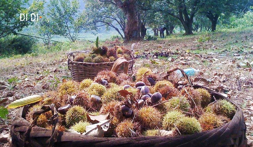
Collecting chestnut in forest (Trung Khanh, Cao Bang)[5]
In The American Journal Of Clinical Nutrition, it is said that chestnut can reduce LDL (bad cholestrol) for people with high LDL. The LDL falls down by 9% in the first month then by 12% in the second month after people with LDL add chestnut in their menu. The research also confirms that the fruit will not affect HDL, a good cholestrol. Certainly, the chestnut can be used to cure people. At the moment, the brand of Trung Khanh chestnut has been all over the North of Vietnam and even China.
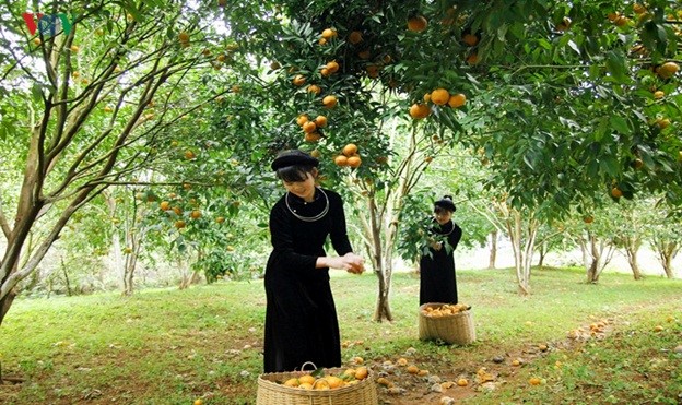
Tra Linh Mandarin
Tra Linh mandarin is a favourtie specie of mandarin. It is planted from a long time ago in Quang Han Village because the soil here can give better quality and capacity. People like it because of the sweet that it only has, less sour, higher nutritions, watery and the beautiful shape. Its price is higher than other species of mandarin.
 [6]
[6]
Today, Tra Linh District has around 60 ha of mandarin, being planted mainly in Quang Han Village and be spreaded to Cao Chuong Village, Lưu Ngoc Village and Hung Quoc Town. Local people have already known intensive agriculture, by strictly following the techniques of growing the fruits, the mandarin make it uses, bringing in 200 – 300 million VND/season income, a lot of family got out of poverty, taking steps to be richer.
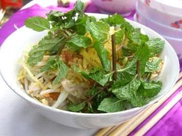
Sour Phở of Cao Bằng
The sour Phở of Cao Bằng is definitely held the limelight spot of Cao Bang culinary. One of the best dishes in Vietnam, Cao Bang Phở is a cool, flavorfully abundant and it is suitable to eat during autumn or summer. Used to be served in special events, the sour phở is now served as breakfast.
Sour Pho – Cao Bang[7]
Cao Bang phở is special thanks to its rice vermicelli’s softness, the fleshy of the livers, the fat of bacon, roasted duck, the spicy of chili, the extra fat of peanut, and the aroma of the pork’s intestine. In the summer time, it is good to have the sour of the sauce. The first time, you may find it peculiar, but the next time, it is nothing but delicious.
Lung Noi Brocade weaving village, Phu Ngoc commune, Ha Quang district – one of cultural heritage located on the Northeast route – Experience history and Freedom. This is one of the tourist stop that visitors can understand more about cultures, history, faith and traditional practice of local people. Brocades are typical weaving and sewing products of Tay people in Cao Bang province. Brocades of Tay people are very well-know for colorful, eye-catching, traditional patterns which was passed from generation to generations. Brcades in Cao Bang are popular and quality brocade weaving products can be found in communes such as: Dao Ngan, Phu Ngoc (Ha Quang), Dan Chu, Duc Long and Nuoc Hai town (Hoa An district). Typical color and patterns of brocade weaving products of Tay people in Lung Noi, Ha Quang. The major ingredients for brocade weaving are indigo-dyed cotton yard and dyed silk. Particularly, there are 6 main colors on a Brocade of Tay people including blue, red, yellow, purple, white, black. From these main colors, the weaver concocted strong and light colors depending on the type of each product idea. The arrangement of patterns on brocatelle is various, resulting in special and different products. Typical patterns adopted in Tay’s Brocade usually are images of flowers, birds, animals …, which are very close to their daily lives, then mixed with clouds in the sky, mountains and rivers. These details make Tay’s Brocade of Tay people in Cao Bang different from Brocades of Tay people in other locations.
Typical color and patterns in the Brocade weaving products of Tay people in Luong Noi village, Ha Quang, Cao Bang.
Till now, Luong Noi village in Phu Ngoc commune, Ha Quang district is the only area that still retains this traditional brocade weaving of Tay people. The woman in the pictures above is Mrs. Nong Thi Thuoc has maintained this tradditional practice for 4 generation and she is the first brocade weaver of Tay people who was awarded the tile of “Golden award for Vietnam traditional craft family” by the Vietnam Craft Association on August 27 2016.
Phia Thap incense village
The incense making craft of the Nung An people in Phia Thap has a long history. Although no one knows the founder of this traditional craft, incense making has been inherited from generation to generation, creating work that is well known for every villager.
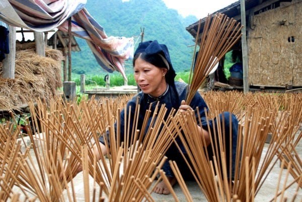
Drying the incense.
Phia Thap incense is made entirely from natural materials in karst regions, including: Bamboo trees (“may muoi” in Tay language) for making sticks, bark of bombax ceiba tree, and sawdust and especially leaves of the wild tree named “bau hat” to make glue for bonding the materials together.
Making incense is not difficult but it must go through several stages. Bamboo tree is cut into pieces of about 40cm long, split into small bars in the size of a chopstick and then tidily polished. The “bau hat” leaves and barks of the bombax ceibatree are well milled and mixed with sawdust. Apricot sticks are soaked in water that is mixed four times with powdered “bau hat” leaves to create a glue, then seasoned with flour mixture of “bau hat” leaves, bombax ceiba bark and sawdust to create incense sticks. After drying, the sticks are dyed red at its bottom half and dried again, before being tied into bundles to sell at fairs. Making incense not only brings income to the Phia Thap villagers but also contributes to preserving a traditional craft of the Nung An people. It is a beauty imbued with national identity associated with the custom of the Vietnamese to worship via burning incense in the Non Nuoc Cao Bang Geopark.
Phuc Sen forging village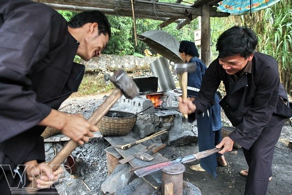
The family of Nong Van Loi in Pac Rang Hamlet, Phuc Sen Commune perform the traditional blacksmith craft.[8]
Currently, Phuc Sen village has nearly 400 families, all being Nung An people. More than half of the households are engaged in forging, so the village has become the largest “forge factory” in North Vietnam selling different kinds of knives, swords, broadsword and production tools. Many families have practiced forging for tens of generations. The forging products of the village are famous for their sharpness and durability, and are sold throughout the country as well as being exported to China. The people of Phuc Sen village say that the way they forge a knife is different from that of the Kinh people. Before they make the shank, they have always forged the knife blade until they are satisfied with the sharpness. It implies that the quality of the product is more important than the appearance. They have an innate ability to sense the steel so that products are durable but not brittle, and flexible but not soft. The water to harden steel is prepared using secret methods by each family. Usually it is a mixture of lime water with charcoal ash of ironwood that is left overnight before use.
There is a plausible feeling that perhaps Phuc Sen forging village is fortunate to have inherited the essence of the brilliant Dong Son Culture that is famous for bronze arrows in the time of King An Duong Vuong. However, thanks to the natural conditions of the karst forests with an abundant source of minerals such as iron, tungsten, tin, and copper, and the skill, wisdom and diligence of the Nung An people, they were able to develop the sophisticated products.
Belonging to the Phuc Sen commune are other handicraft villages, making e.g. Poonah paper, incense. Thế Pác Rằng community tourist village in this commune is also doing well. The Phuc Sen forging village also has some geoheritage values such as Crinoid fossils in limestone of Bac Son Formation (C-Pbs), peak cluster-depression landform, karst field, and triangular facets on limestone cliff as evidence of fault activity.
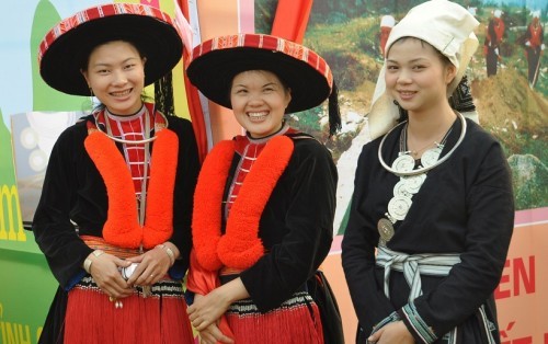
Garments
The most popular costumes in Cao Bang are of the Nung and Tay’s that are made from simply-decorated indigo-dyed fabric. The Dao’s garments are more colourful and diverse, including two types, which can be identified by their black trousers embroidered with flower or small star patterns. The garments probably express their different perceptions of the world. While the Tay and Nung people want to live at peace with the nature, the Dao people try to indicate that they are the owners of the place by wearing chunky high-sounding silver jewelry on their necks, hands and waists.
The Tay men’s garments include an indigo-coloured long dress, white trousers, a turban (the top of which slanted backwards) and cloth-made shoes. The Tay women wind the plait of their hair horizontally and cover it with a square kerchief. They wear an indigo-dyed long dress with bronze buttons on the right and an indigo cloth belt the two ends of which are let straight down on back. The Tay people themselves weave and dye their indigo cloth. The garments of the Nung people are more diverse than those of the Tay people; however in general, the main features are similar. The Nung women’s shirt has a collar and large sleeves decorated with bright multi-colored cloth pieces with indigo still as the major color. The Dao ethnic group has various types of clothes, which have distinctive features. The main Dao branches in Cao Bang are Dao Tien (Coin Dao) and Dao Do (Red Dao). The Red Dao women wear splendid garments made of black material embroidered with red cloth pieces. The 8-si kerchief (Ca pha) is wound around their head, looking like a flat hat. Their sides are covered with cloth bands (pha xi) decorated with a number of embroidered motifs in red threads. Their belts (xi lo chin) are embroidered with sophisticated motifs. Their shirts have long taps and hemmed sleeves. They open on the breasts to reveal the light-coloured bras with two strings of eight tassels (nom lang gau) each inside. Their large-legged trousers (hau tao) are decorated with green, red, brown or white squares. On their backs, there are material squares (nom kie) skillfully embroidered.
Red Dao and Coin Dao garments[9]
One of the significant values of Non nuoc Cao Bang UGGp is cultural heritage. Tay and Nung people living in Non nuoc Cao Bang UGGp posses distinguished custom, which is of cultural identity and really human. “Visiting wife’s parents” is a traditional custom of Tay and Nung people, it is usually practiced on the 2nd day of the Lunar new year and on the the lunar July Full moon festival.
“Visiting wife’s parents” on the the lunar July Full moon festival is the responsibility of the Tay and Nung women after they get married. All year round, they spend time with their own family and work at their husband’s house or their own houses and take care of their husband’s family. In the year, only on the 2nd day of the Lunar new year and on the the lunar July Full moon festival do they have time to visit their parents and present their gifts to their ancestors. In addition, in the Tay and Nung people also celebrate the “Ghost Festival” as other Kinh or (Vietnamese) people. They also prepare their “gratitude-to-parents or their ancestor” gift, which is similar to the Ghost Festival in Buddhism.
On the lunar July Full moon festival (Ghost Festival), the daughter and son-in-law and their children usually visit their parents in the early morning and bring with them gift for the parents, which will be incomplete without a pair of ducks to show their gratitude to their parents and ancestors. Once they arrived at the wife’s house, gift will be placed on the altar with lighted incense, then people will prepare the duck together to make traditional dishes from duck.
One of the most typical dish from duck of Tay and Nung people is roast duck. The duck, after slaughtering, will be marinated with local spices such as the leaves of Clausena indica tree and coat its skin with a thin layer of honey bee, then it will be put in the oven. Now the roast duck of Tay, Nung people has become a special dish. Tay and Nung people have some sayings about their food traditions such as: chicken is for the lunar New Year, duck is for lunar July Full moon festival. According to their tradition, the duck is belived to be one of the sacred animals because they belive that the duck is the ambassador from the heaven. On the On the lunar July Full moon festival (Ghost Festival), the duck will escort the rooster through the sea as a gift for the gods. (Theo Báo Cao Bằng)
Some spring festivals in the Eastern route of Non Nuoc Cao Bang Unessco Global Geopark
Apart from geological, bio-diversity, and historical heritage, intangible heritages of Non nuoc Cao Bang UNESCO global geopark has made up particular and exception significance of a UNESCO global geopark, especially the Sung Phuc pagoda spring festival and Phao Hoa cracter spring festival in Quang Uyen district.
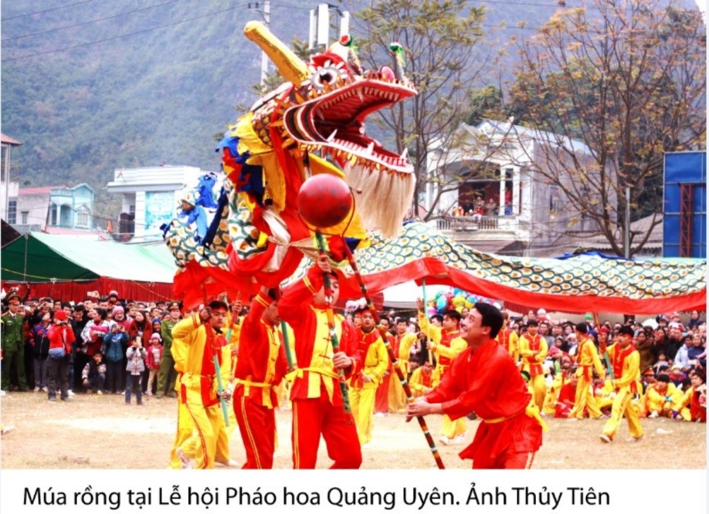
Dragon dancing in Cracker spring festival.
*Sung Phuc pagoda spring festival
Sung Phuc pagoda spring festival, located in Huyen Du village, Thanh Nhat commune, Ha Lang district. The pagoda, built during the Tran dynasty, is located in the rectangular shape campus in the Norther-South direction. The pagoda, which closely associated with buddihsm, is accommodated with the statue of the Bodhisattva in the harem. While Thanh Hoang shrines, which is located in the campus, was built for worshiping Nguyen Dinh Ba- A Sennior integrity officer, who was highly respected by local people. In addition, the pagoda is also used to worship Dr. Nguyen Thi Due, who practiced Buddhism for 6 years in the Pagoda with the nickname of Huyen Du. She also taught Buddhism to people and was highly respected by local people, people also named this pagoda as Huyen Du pagoda. This pagoda was ranked as the provincial level monument in 1993.
Untill now, the Sung Phuc spring festival is organized annually on January 15 (lunar calenda). For the ritual practice, the organizing committee and local people first put the insence on the altar to show their respects to the Bodhisattva and thank for her protection for peace, security, happiness, and prosperity
The ritual practice will be followed by lots of festival activities and traditional games such as pushing stick, tug, chess, etc. Particularly, the exchange of traditional love songs such as Ha Leu, Luon Then, Nung Khen, ect among young couples which is usually an attraction to people of all ages in the Festival. In addition, Chinese people who are living near the border area of Ha Lang district usually come to join the Festival.
*Phao Hoa (cracker) spring festival in Quang Uyen district
The Phao Hoa Spring festival in Quang Uyen district is organized annually in February (lunar calenda) in some areas of Quang Uyen, Phuc Hoa, Ha Lang and Thach An district. The Festival, celebrated in Quang Uyen district, is organized annually on the February 2nd (Lunar calenda).
Before the festival comes the ritual practice, which is celebrated from the afternoon of the previous day (February 1st). The organizing committee of the Festival and local people come to the Bach Linh shrine, which located at the entrance of the town to present their offerings and pray for good luck, prosperity and protection from the god. Bach Linh was built for the worship of more than 100 sacred gods, which has been its sacredness, on the top list of these sacred gods is the dragon, one of the most four most sacred god with magic power.
The next morning February 2nd (Lunar calendar) will followed by the procession of palanquin of local gods, then the cracker, and the palanquin with the roasted pig and lastly the procession of the dragon. Nowaday, people also use the palanquin with picture of uncle Ho to lead the procession. The practice of god procession started from the Bach Linh shrine to Nung Tri Cao Bang temple, which dated back to the Tran Hung Dao dynasty. The procession delegation escort the palanquins through the town, public offices, households with the aims to bring gods to visit local people and give them good lucks, and people are really happy and excited to receive the procession delegation.
The festival activities are organized in the afternoon of Febuary 2nd, especially the cracker game. This is one of sport game which promotes and requires physical health and the combination of skill and spirit, assert, activeness, knightliness, great-heartedness of young people. The organizing committee will gather the young males circling the center of the game; the one who get the wreath hung at the head of the cracker is believed to have good luck and prosperity in the year. The award for the winners will be the roasted pig and the head of the roasted pig will be reserved for the one who got the wreath. On this day, almost all household will make 5 color sticky rice and roasted pig, one of the most special dishes in the Festival together with other local snacks and drinks. Visitors to the Festival might be entertained with dragon dancing, football, the exchange of love longs of young couples, and traditional games which help to make up a distinguished traditional Festival of local people.
The Cracker festival in Quang Uyen is one of the most interesting one in Cao Bang and attracts lots of visitors. In addition, Quang Uyen district locates in the center of the region and in a favorable position connecting to other main transportation routes of eastern districts, which ease the travel of nearby people. (by Lê Chí Thanh)
The village of Tay ethnic group celebrating Lunar New Year
Tay is the one of the most populous ethnic group living in Non nuoc Cao Bang UGGp. Their main settlement area is near the rivers like Bang, Ky Cung, Cau, Gam and Chay, etc of Cao Bang, Lang Son, Bac Kan, Thai Nguyen, Tuyen Quang, Ha Giang, Lao Cai, and Yen Bai). They live in a big community or village with at least 6-9 household. This is the reason why other ethnic groups are influenced by tradition, practices and even language of Tay ethnic group when they join Tay community. In contrast, because of the cultural exchange with other ethnic groups, Tay ethnic groups are also impacted, backward practices were removed and traditional values are preserved and updated with new and proper practice of the modern society, including the Lunar new year, which is also the main festival of in a year of Tay people.
Tay ethnic group prepare very carefully for the Lunar new year. Before the first day of the Lunar new year, the Village of Tay ethnic group is busy preparing for the festival such as : Ginger cake (pẻng khinh), green bean cake (pẻng dỏ thúa), sticky rice flour bar cake (sa cao), cooked sticky rice flour (chà lam), fried sticky rice mixed with sugar (khẩu si), etc and pop-rice mixed with sugar ‘Thuc Thec’, in which Khẩu si ís the hardest one to make because of different steps.
The village is busy with the sounds of sticky rice grinding to make Banh Day. Rice noodle is one of the main food for the Lunnar new year, first people will soak rice in water, then grind the soaked rice to get the water flour and pour this water floor into a bag to seperate the flour and water. Normally, three or four household would share one pig of about 100kg, and pork would be prepared before the Lunnar new year. The insence and fake paper money are bought and prepared before the New year. Chung cakes are wrapped carefully in pattern, the green color of the cooked Chung cake is decided by the front side of the wrapping leaf ; there are two types of the inside of the Chung cake, one is sweet and the other is salty. Particularly, each household perpare a pair of big Chung cake considered as the Parents cake with the best inside (normally fat pork, green bean, sweet potato, cane juice sugar, moutain ginger, etc)
In the afternoon, people would gather their cattles back home. On the last day of the old year, people would cook Chung cake for the whole day until night time (about more than 10 hours) ; family members take turn to take care of the Chung cake, and each member would have a shower with Pachira aquatica leaf, it is believed that this kind of leaf would help people have smooth skin and stay away from skin diseases.
From 12 p.m to 1.00 a.m people would wake up to welcome the new year’s eve.
People would light the incense and put them on the altar which was cleaned before, the good smell from smoke of the incense would pervade through the house ; cakes and gifted are presented on the altar to their ancestor. The house owner would then pray for the protection and support from their ancestor for a new year with good luck and fortune. The incense is pitched at the gate of the house to guide and welcome the soul of their ancestors backhome; it is also pitched at the kitchen, cattles cages, etc. Their oldest child would bring a bunch of incense and a pair of bustket to the water well to pitch incense there and bring back home the lucky water. The village will be loudly wishing the best luck for the new year, especially at the water well or crystar running streams. School students would then sit at desk to read book so that they would get more intelligent, etc. For this day, the above mentioned preparation procedures have been shortened so that people can gather together and watch TV, etc.
On the first day of the new year, the Tay ethnic group would stay at home and enjoy the festival with each other. People would prepare the meal together like rice noodles, cake, chicken, ducks, etc.
Previously, Tay people paid serious concerns for the first foot on the first day of the new year. Though gender bias is not a problem in nowaday society, people are still not really happy with the women first foot. People used to choose the first step by considering the match of the year of the house owner and the first foot.
It would be perfect if their friends who live far away from their house comes to visit them for the first foot, but again they need to know the lunnar year of the house owner. Moreover, the Tay ethnic group tend to stay at home on the first day of the year but not visiting other friends’ house. Because they are afraid that they would pour their good luck to other house (vải dài). Once visit their relative on the first day of the new year people need to pay attention to the frest branch of tree, for some reasons if the house onwer might not want to welcome the guest at that time they would hang a branch of tree at the door (bâư phật).
On the first day of the New year, the household need to take care of departuring to pray for good luck and fortune, and deepending on their age, people would choose a suitable time and direction for departure.
A new trend of Tay ethnic group is that people gather and meet each other at the cultured house on the first day of the lunar new year (at about 9 a.m) to sing the national anthem under the flag and listen to the new year letter from the President, and the schedule of new year activities of the village and contribute to the awards of games.
On the second day the family would visit the wife’s parents. The wife and her husband, children would bring their presents to show their gratitues to the wife’s parents. The wife’s parents would give lucky money to children in red envelops.
The joint year games of the village would start from the early morning of the third day.
Tomb sweeping festival in Cao Bang
Apart from biological and ecological value of international significance, Cao Bang in general and Non nuoc Cao Bang UNESCO global geopark is famous for its identical and distinguished cultural values. Cao Bang is home to more than 95% ethnic minority groups with their own traditions and practices. It is their identical feature which has helped shape a colorful and cultural diversity picture such as traditional folk songs of groups such as Then, Ha Leu, SLI, LUON, and different traditional festivals such as Long Tong, Fire crackers, Nang Hai, in particular the Tom Sweeping Festival of Nung An people in Phuc Sen Quang Uyen, Cao Bang.
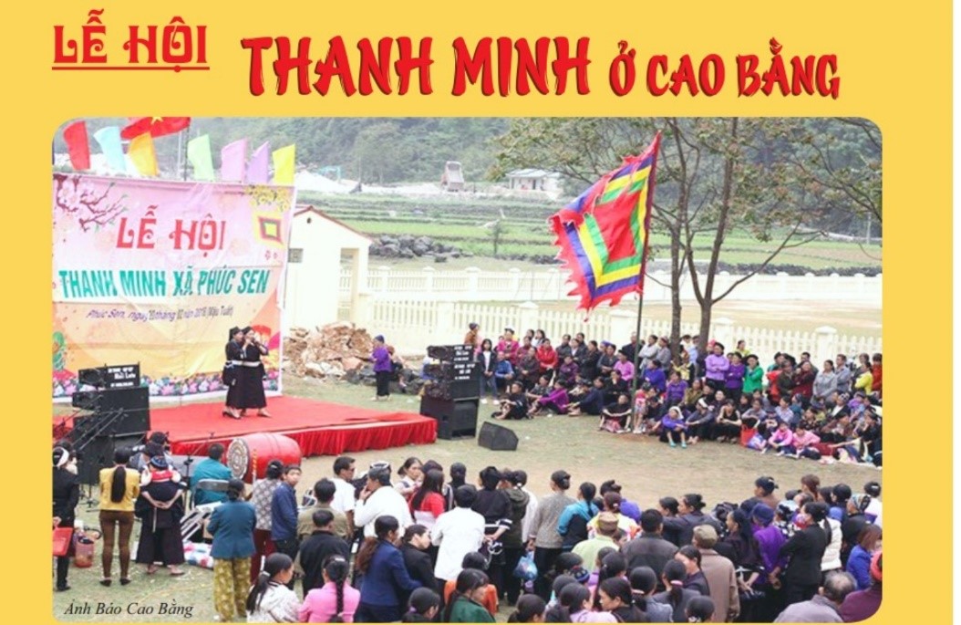
Tom Sweeping Festival of Nung An people is celebrated on the first day of the fifth solar term of the traditional lunar calendar, normally it is after the Spring Equinox, either 4 or 5 April (lunar calendar) in a given year, in Phuc Sen commune, Quang Uyen district. According to the people in there, this festival is celebrated to memorize and praise the faithfulness of a young couple with true love, ordinary and simple life and agaist backward and feudal practices. The festival is celebrated to pray for good crop as well. The name of this festival in Nung language is “Sinh Minh”.
Once upon a time, there was a young man named Sinh (Thanh) in Phja Chang valley, Phuc Sen commune, who was smart, good-looking, and strong. During his time, there was also young woman named Mình (Minh), who was very beautiful and gentle. They were both very hardworking, kind, and fancied by other peoples in their communities. They met and fell in love with each other deeply. Since Sinh (Thanh) loved Minh too much, he invited Minh to come to stay with him while they hadn’t completed marriage procedures according to their tradition. This was against their tradition in which their parents would arrange their marriage for them. Some of the people in their community commented that this doing was against tradition. Although people in the community knew that it was their true love. Meanwhile, in the region there was a greedy and perfidious official, he wanted to marry her as well. He tried to flirt, threaten and seduce her in order to get what he wanted. The young woman denied the wealth and gorgeous life promised to her and followed her heart love with the young man. The backward tradition and the perfidious official prevented their true love and this made them feel really sad. However the young man and woman still loved and stayed with each other. Time passing by, their lives became harder and harder. They felt so hopeless that they committed suicide; they jumped into the deep blue water area close to an old banian-tree where the young man and woman promised to love and stay each other forever. It was so strange that the water area turned into a fresh stream and wherever the water ran to, the area, trees and crop became fertilized, and local people had good livelihood and prosperous lives. It was said that this was owning to the protection from souls of Mr. Sinh and Ms. Mình, though they passed away, they still missed and loved their homeland. Since then people put an incense burner near the water area to show their gratitudes to the young couple; hoped that they would not be splitted up, and praying for good health, good crop. The people in the area chose the first day of the fifth solar term of the traditional lunar calendar to celebrate the festival and name the festival “Sinh Mình” “Tomb sweeping festival” to memorize their young couple Sinh and Minh (Thanh Minh). The old water area because of long time alluvion and accumulation was changed into the water well of Phja Chang village, near the Kindergarten and Primary school of Phuc Sen commune. Annually, on that occasion, young men and women in Phuc Sen commune still come to this area to look for their spouse and promise their love in there.
Once coming to join the festival, we will be aware of the presence of a temple near the People’s committee of Phuc Sen commune worshipping the Land God which dated back long time ago. Time passing by with historical events, the temple was deteriorated. After 1979, local people renovated the temple and roofing with Yin Yang tile, and developed a middle altar with ancestral tablet and two parallel sentences in Sino-Vietnamese. This is the place to hold the memorial ceremony to memorize the tragic love story, and for young couple to express their exception of love, while carrying out practice to express gratitude to the Land God to pray for good crop and weather. Most of Nung An family coming to join the festival always bring good food and fruits, wine, etc to present at the temple altar in order to show their respect to the young couple. After that, people start praying near the water well, where Mr. Sinh and Ms. Mình died. Thanh Minh festival (Tomb sweeping festival) is a traditional festival demonstrating belief, spiritual life and inclined to the good of Nung An people. In addition, it is suitable to the needs of spiritual practice of ethnic minority groups. This explains why people, especially young people enthusiastically sustain this traditional festival.
Nang Hai Festival
Nang Hai festtival of Tay in general and the Nang Hai festival in Tien Thanh, Phuc Hoa in the east of Non nuoc Cao Bang UNESCO global geopark in particular reflects the Mother worship religion of the Tay people in Cao Bang. According to the faith of Tay people, the Moon Mother and Fairies live on the Moon, they help to protect and secure properous crop for the people. The Nang Hai festival is organize to demonstrate the moon journey to receive and welcome the Moon mother and Fairies down to the earth to visit field, homes and experience daily life of the people and help people on the earth with good life, crop and properous business.
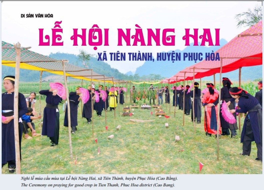
The Nang Hai festival in Tien Thanh commune with community based performance is typical among festivals of Tay people, which includes all the three parts namely praying for good crop, happiness and love. In nature, this Festival reflects the Mother worship faith through typical ceremony soul extraction – a phenomenon of Shaman religion.
In Cao Bang, there are other areas that are celebrating Nang Hai festival as Phuc Hoa district such as Thach An, Bao Lam, Bao Lac, Trung Khanh and they also include the Three parts. However, the Festival celebrated in Phuc Hoa is the most special one, which demonstrates history that related to the Mac dynasty in Cao Bang. Currently, in Phuc Hoa, there are some areas celerbrating Nang Hai festival including Nua Khau, Bang Giuong, Nguom Cuong, Ban Chap but these are fading away, only Ban Nua Khau usually celebrate Nang Hai festival in even years (lunar calendar).
Nobody is sure when this Festival has been being celebrated, it is know that this started since farmers wanted to send their wishes to a Fairy, in this case the Moon mother. However, as mentioned above this Festival also related to the existance of Mac dynasty in Cao Bang. Till now, there is a folk saying about a moved love story between the General Dinh Ta Van and a girl-who is belived to be the Mac princess and this girl characster is the inspiration for the choral singing performance in the Nang Hai Festival in Tien Thanh Commune, Phuc Hoa district. As being known that, the Mac was considered the Dynasty of usurper, existed for about 150 years. The recorded history of Mac dynasty in Cao Bang is very little, information is not enough and precise, especially the last years of Mac Dynasty. Based on the historical evidents, folk tales, and remnants, we can inteprete about historical events relating to the existances of Mac Dynasty in Cao Bang province and its influences on the contemporary Nang Hai Festival in Tien Thanh, Phuc Hoa, Cao Bang. According to the recent survey, it can be intepreted that this Festival was started in Tong Lao (Tien Thanh commune) then dissemniated to other areas. Owning to the General Dinh Van Ta and the Mac princess, this Festival has been celebrated with more associated meanings. From the activities in the Festival, we can easily see the connection between the daily life and faith of Tay people. For farmers, their best concern is favorable weather and good condition, healthy castles, etc which are all demonstrated in Nang Hai festival.
In addition, Nang Hai festival reflects good practice of traditions of Tay people. Community union and respect are nice behavior in culture of Tay people. The Nang Hai festival has helped encourage and maintain these practice. This is a days, community-based performance festival, not yet including consensus among the community before and during the celebarion of the Festival. For such a Nang Hai festival, it requires efforts, consensus, and solidarity of Community. The Festival is an opportunity for to build friendship and love among community members. The build-in holy solemnities of the Festival help to maintain the neat and order from the commencement till the last moment, which is also a symbol of community repspect of Tay people. Elderly repsect and taking-care children are another nice traditional practice of Tay people. In the Festival, Elderly is the one who make decisions. They play the important characters of the Person who guided Nang Cuong, acted in the roles of So and the Mother-who is usually very knowledgeable and respected character, besides the voice of the young is heard and they are guided by old people too. Actress in The Nang Hai festivals now are young girls and are guided by the old people. Another humanism values should be mentioned here is the freedom in marriage of Tay people. The Festival lasts several days, with the tradition of inviting friends coming for exchange of songs is a good opportunity for men and women in other villages to meet and date. Hospitality is a good tradition which demonstrated in the Nang Hai Festival. It is believed by Tay people that the more hospitable families are, the luckier they are. Nang Hai festival is a friend reunion day with open stories from bottom of their hearts. This traditional practice should be kept and maintained. Nang Hai is a choral singing performance festival that is not very popular in other Festivals. As initiated by the inspiration of the Festival, the couple-singing lyrics are very humane. Words used in songs are very descriptive with flexible performance. Furthermore, the Praying for good crops songs contained a sum of vocabularies of Tay language, which help researchers understand more about the development process of this language. Though dancing performance in the Festivals is not popular, it warms up the atmosphere of the Festival. The combination of dancing with traditional songs makes the Festival very attractive and lively. In addition, the attraction of the Festival also includes other types of cultures such as: arts of decoration of the Festivals, wooden board carving, painting, and especially the art of food presentation, and craft gifts, etc which added by the colorful flower given to Nang Hai, the beauty of costumes of Cuong, So, fairies and the Mother. It can be said that apart from the spiritual belief practice, visitors to Nang Hai festival in Tien Thanh commune, Phuc Hoa district might be able to enjoy the creativeness of arts. This Festival gradually regarded as the typical community and cultural practice of Tay people in general and Tay people in Tien Thanh commune, Phuc Hoa district in particular. With outstanding historical and cultural values, the Nang Hai festival of Tay people in Tien Thanh, Phuc Hoa, Cao Bang province was listed and awarded the certificate of National intangible heritage in the Decision No 2459/ QĐ-BVHTTDL by the Ministry of Culture, Sports and Tourism on July 20th 2017. Besides, there are many other festivals hosted in Cao Bang: Long Tong Festival; King Le Temple Festivals; Quang Uyen Fireworks Festival.
The legend of “Cẩu chủa cheng vùa” is about the establishment of Nam Cuong State under the rule by King Thuc Che and his son Thuc Phan, who later became the king of Au Lac State and moved the capital to Co Loa in present-day Hanoi’s Dong Anh District. On the other hand, the legend authentically describes the land of Cao Bang, with a flat valley in the center, surrounded by ranges of mountains. A series of places in the ancient Ban Phu Citadel were also described through the legend, reflecting the perceptions of the ancient people about natural landforms.
According to the legend of “Cẩu chủa cheng vùa”, the land of ancient Cao Binh was located along two sides of the Bang Giang river with Hoa An basin at the center. It includes 10 regions (9 villages and 1 center). The center village was ruled by Thuc Che, with title of An Tri Vương, who established Ban Phu Kingdom and the capital Nam Binh. Surrounded the other nine regions were vassal states governed by the lords named: Tien Dat, Kim Dan, Van Thang, Ngoc Tang, Thanh Giang, Quang Thac etc. They together established the Nam Cuong State, which was contemporary with Van Lang State of Hung Kings and the Lac Viet people in the south. Thuc Che reigned for about 60 years and died at the age of 95 when his son Thuc Phan was only 10 years old. The nephew of Thuc Che, named Thuc Mo, helped Thuc Phan to become a regent but as he abused power, all nine regional lords were disobedient. They pulled troops to the center in order to force Thuc Phan subdivide the national land, and asked him to abdicate the throne of “the king”. However, Thuc Phan was very smart at such young age that he organized talent competitions with promise to cede the throne for winner.
The talent competitions were organized with stratagems. They were all very difficult and time-consuming, such as shooting falling banian leaves, making 1,000 needles from a plowshare, and even with “beauty trap” by assigning 10 beautiful young ladies to accompany the competitors etc., consuming much of time and effort. They were so hard that none of the competitors could complete their exams and therefore the lords had to submit to King Thuc Phan.
According to the legend, Ban Phu Citadel was located on a large area surrounded by rivers and fields in the nowadays Hung Dao Commune, Cao Bang City. This was the imperial court of the Palace during Thuc Che-Thuc Phan Dynasty and even the later Mac Dynasty. At that time, the military castle was based in Na Lu (the present-day Hoang Tung Commune, Hoa An District).
Ban Phu Citadel was built in a very beautiful location that faced to the Southeast. At the front of the Citadel was a 7ha-wide lotus lake and Cao Binh Plain, followed by the Tong Chup field. The field was initially called Tong Quang field to infer a large field, but later the name was changed to Tong Chup to refer to a story about the competition of Tien Dat Lord, who could not complete cultivating the entire rice field leaving an area “as tiny as a hat” unfinished. Close to the foot of the inner wall was a jade well (now called Bo Pho) that had clear water for all year round. Near the Lotus Lake were the Giao and Thien Thanh temples, which were rumoured as the places where the King worshiped the God. On the right and left sides of the wall was Peach garden (Dao Vien) of the Queen’s palace, namely Dong Tam, next to the resident place of maidens. The upper part of the hill, namely Thom Dang, was used to raise elephants. The kid area was called Ho Nhi or kid’s lake. Near Ban Phu, there was an ancient banyan, which was a place where Kim Dan Lord used his bow and arrows to shoot almost all the falling banyan leaves. Out of the outer wall, near Dau Go, there was a pair of giant stone clogs incompletely perforated to pierce straps, as a result of Van Thang Lord’s competition. Riding about one more kilometer along Highway No. 4, on the right side of the road appeared a hill called Khau Lua, i.e. boat hill, which tells a legend about the boat that Ngoc Tang Lord had yet to complete turning upside down. Opposite to Khau Lua, on the other side of Bang Giang river bank was Na Lu Citadel (with the King Le’s temple and festivals celebrated annually on 6th lunar January), which still lack a gate, as an unfinished work at the talent competition by Thanh Giang Lord. The other lords competing to write poems or make needles all failed because when the contest was almost completed, they heard the drum sound of Quang Thac Lord and supposed that he had won. In fact, Quang Thac also failed due to the “beauty trap” of Thuc Phan that dropped his drum rolling down the abyss and made echo of the noise. The place where the drum rolled down was named as Tong Lan.
Relics of the Hoa Binh and Bac Son cultures date from 17,000 to 7,000 years ago, associated with the Flandrian Transgression. Relics are found in such caves as Nguom Boc (Hoa An), Nguom Cang (Trung Khanh), Hang Na Con (Nguyen Binh), Nguom Chieu (Quang Uyen), and on the terrace of the Binh Long river (Hoa An), as well as in some other caves outside the Geopark, such as Nguom Cang, Nguom Vai, Hang Than (Thong Nong district). Stone tools found of moderate size, manufactured from river and stream gravel using rudimentary flaked or simple blading techniques. Studies of occupation and settlement sites suggest:
– Although limestone valleys and caves were home to most of the inhabitants of this epoch, in the northeast mountainous areas hilly terrain and river terraces were also favoured for settlement.
– Preferred hunting and gathering areas were lowland and mountain river valleys, and forests.
Nguom Boc cave (Hoa An)
Nguom Boc cave monument is in the territory of Ban Nua commune, Hong Viet, Hoa An district (coordinate: 617256, 2511578); It is a national revolutionary historical site about 2km to the north of Hong Viet commune center. At this place on October 1950, President Ho Chi Minh generalized the Border Campaign. (Nguom Boc means Dry Cave in local language). In the famous Pu Luong – Sao Cai legend of Tay – Nung people, it was the first residence of the two aforementioned legendary figures in Cao Bang. The cave distributes in the western slope of Lam Son Mountain with a large dome-shaped cave mouth opening to the west and an area of about 300m2, divided into two large chambers. The first chamber is located and the second chamber has 2 stone pedestals which were built by cement and relatively big. These are the vestiges of machine pedestals of a military weapon workshop in the 1950s.
The relics include:
+ 3 rudimentary chopping tools, 1 Hoa Binh-style oval tool, 2 scraping and cutting tools, 2 grinding pestles, 3 material pebbles; all were processed from pebble stones in rivers and streams by simple flaking and chipping techniques. The tool shapes are typical of Paleolithic nuances. Nguom Boc collection does not contain Son Vi technical characteristics but processing in Hoa Binh style is still fuzzy.
+ The presence of a sediment block which is more than 1 meter thick and densely containing stream shells suggests they were food remains of the prehistoric man living in a rainy period with the development of aquatic species. Based on C14 analysis of stream shells in the sediment (results: 7.420 +-95 yn and 6.820 +- 95 yn), archaeologists have predicted that the layer of archeological site dated back to about 10,000 years ago(there are still approximately 10m3 of sediment containing stream shells and tools, distributing along both sides near the cave entrance).
Based on the overall research on archaeological relics, colors and compositions of sediment and fossilization levels, archaeologists assumed Nguom Boc is a resident relic of the primitive people living at the beginning of the Holocene period about 10,000 years ago, equivalent to the period of early Hoa Binh culture.
Nguom Cang cave (Trung Khanh)
Nguom Cang cave monument is located in Ban Gioc, Dam Thuy, Trung Khanh district. Coordinate: 675737, 2528391; It has a dome-shaped entrance with approximately 15-20m width, ~10m height, many stalactites hanging, facing the north. There is a karst valley in front of the cave. The ancient karst cave floor is about 3m above the field surface. The cave is quite wide with an area of about 300m2; a small niche penetrates into the cave in the southern part.
Archaeologists have surveyed (May 2001) and preliminary discovered 23 stone relics of the primitive people. In particular, 7 templates were found on the surface and 16 artifacts were in the cultural layer, including rudimentary chopping and hitting tool (horizontal blade edge), flake tools, flaking and hitting stone, flakes, and pebbles with flaking traces.
Most of the relics were processed from pebbles. It is likely that Nguom Cang residents found pebble source in Quay Son River to make tools. Flaking and chipping techniques were simple, direct and limited on one side and on the edge of pebbles. Tools have an ancient look; formativity in tool shaping technique is low; and forms of tool typical of the Paleolithic traditional culture are not diverse. There is no grinding stone and pottery. These remains show gathering had a particularly important position in the methods of searching for food sources of the primitive people [6]. Based on processing techniques, types of relics found and sedimentation level of the cultural stratum, archaeologists initially assumed Nguom Cang is the residence monument of Stone Age people in the early Neolithic period.
Nguom Cang cave (Thong Nong)
Nguom Cang cave is located in Vi Quang commune, Thong Nong district (outside the Geopark) (Nguom Cang means Gibbon cave). Nguom Cang is essentially a stone roof distributing over the steep slope of a limestone mountain – limestone slope and wall are vestiges of NW-SE tectonic fault. The height the wall foot up to the cave entrance is about 50 meters; there is a tectonic valley in front of the cave entrance and Thang Lat stream along the valley. Nguom Cang monuments include:
+ Monuments (3 types)
– Fire monument: a greyish white ash layer with uneven thickness from 2cm to 4cm has been discovered. In the coal ash was burnt shells and some broken animal bones.
– Animal bone, tooth monuments are identified as of deer, pig, goat, monkey, bamboo rat, chicken, bird, porcupine etc. Notably there is a piece of pig jaw with burn marks, indicating they are the remains of the ancient food. Most animal bones and teeth have not fossilized.
– Mollusk shell monument: more than 30 stream shells with traces of cut penultimate whorl and many crab pincers.
+ Stone relics:
– Group I: the group of traditional tools with significant amount: 41.19%, including spike tools, horizontal edge tools, vertical edge tools etc. This relic group is classified as typical tool group of Son Vi culture of the late Paleolithic period. However, when examining, archaeologists also found differences between the traditional tool group in Nguom Cang (Thong Nong) and Son Vi tools in Lao Cai, Phu Tho, Yen Bai, or in the Northwest area. Analysis of processing technique also found differences between the traditional tool groups in Nguom Cang with Son Vi tools, typically in processing types of vertical edge chopping tools, pebble quarter tools etc.
– Group II: The group of tools of Hoa Binh – Bac Son style takes up of a large proportion in Nguom Cang: 16.05%. They represent the rich and stable Hoa Binh techniques in a number of specific forms, including oval tools, disc-shaped tools, short axes made from unbroken or broken pebbles and mainly having a side flaked by radial flaking technique – Sumatralith technique. Statistics show the majority of Hoa Binh featured tools in Nguom Cang is oval axes (Sumatralith) and short axes. Notably in Nguom Cang collection is “Bac Son trace” relic. The appearance of this relic is likely to be the hallmark of the cultural communication between Hoa Binh inhabitants and Bac Son culture inhabitants. A rather common technique in Nguom Cang is the flaking technique with limitations in pebble edges on one side and in one direction – creating rudimentary chopping tools or spikes. This is a fairly old technique, popular from the Paleolithic and typical of Son Vi culture – a late Paleolithic culture in our country.
Another typical flaking and chipping technique in Nguom Cang is radial flaking and creating forms of Sumatralith tools with oval, dish shape, short axes etc.
A notable technique is grinding technique in Nguom Cang relics – this is a revolutionary factor in the primitive techniques. It completely changed the appearance of flaking and chipping tools which were familiar in millions of years and improved the productivity of the tools.
+ Production methods: Researches on archaeological sites show hunter-gatherer mode is a remarkable feature of daily life of Nguom Cang residents. Whetstones and grinding pestles are vivid evidence of processing food from the flowers, fruits, bulbs and roots of ancient residents here. A large number of spring snail shells found with traces of cut penultimate whorl prove they are an important part of the ancient human food supply. Nguom Cang residents had a rather broad relationship with contemporary residents instead of living in isolation. Studies on stoneware here show that the oval tools, short axes in Nguom Cang are quite similar to the tools of the same type in Ha Giang, Tuyen Quang.
+ Determination of age: Overall research on monuments and relics collected in Nguom Cang cave indicates it is a monument of the early stage of Hoa Binh – Bac Son culture, early Neolithic culture dating back to approximately 8,000-9,000 years ago.
Bang Giang River terrace, Bo Ma village, Hoa An
In the terrace area in Hoa An district, a monument of prehistoric man was discovered (December 2010) distributing in the high ground of Bo Ma village, Hung Dao commune [14]. Here on the avalanche talus and hill slopes which were originally the ancient alluvial layers of terrace level II of Bang Giang River exposed a stratigraphic section containing archaeological relics, mainly flaking and chipping tools interbedded in conglomerate sheets, under a nearly 1m thick layer.
The relics found include spearhead tools (3 units), rudimentary chopping tools with horizontal mounting blade edges (14 products), vertical edge tool (1 artifact), and tool with 2 adjacent edges (2 artifacts).
The tools are made from river pebbles taken from Bang Giang River. Processing techniques are still rudimentary; tools have primitive shapes and grinding technique has not yet appeared. They have featured nuances of the Paleolithic period. Morphological as well as functional analysis of the tool set shows gathering played a particularly important part in the method of finding food sources of primitive people living here. They are spike hand hoes, rudimentary scraping, chopping and hitting tools used for everyday living activities. Based on the processing level as well as the types of tools, we can see that the relics found at this site are preparations of prehistoric people living in the Paleolithic period. On the other hand, the majority of the terrace level II in the north of our country dated back to the late Pleistocene period. From the above analysis, archaeologists have identified Bo Ma as a monument of primitive man living in the late Paleolithic period.
Cao Bang Paleolithic inhabitants with low survival skills had to struggle with the nature, wild beasts and diseases to survive and develop. They chose to reside on two different types of terrain with different conditions: hill, river terrace terrain (Thuong Ha, Bo Ma) and Limestone Mountain, cave, stone roof terrain (Lung O).
Studies on the residence features of primitive inhabitants in the Paleolithic period in Cao Bang showed that they used to live near large rivers and streams or their tributaries. This proves that water played a very important role in the life of prehistoric man, especially the primitive man in Archaeozoic era. Although no remains of prehistoric human have been discovered in Cao Bang, their tools, the stones processed rudimentarily to form tools to make their living, were detected with a relatively large number in Thuong Ha, Lung O and Bo Ma. They are the proofs of residence and work of primitive people in Cao Bang.
Lung O cave, a Late Paleolithic relics
Cao Bang is a cradle of prehistoric people. Extensive archaeological research shows that this area has been home to people for at least 20,000 years. There are relics from the late Paleolithic, such as Lung O (Quang Uyen), Thuong Ha (Bao Lac), Bo Ma (Hung Dao, Cao Bang City) and relics from the Neolithic in Nguom Boc (Hoa An), Nguom Vai, Nguom Cang, Nguom Slan (Thong Nong), Nguom Cang (Trung Khanh). Also recovered from throughout the province are Iron Age artifacts including bronze drums, axes, and javelins, together with a range of ceramics of the Dong Son Culture.
Relics of the Son Vi Culture (Late Paleolithic, 20,000-12,000 B.C) have been found at three sites in Cao Bang: Lung O (Quang Uyen); Bo Ma (Hung Dao commune, Hoa An district, now Cao Bang city) and Thuong Ha (Bao Lac). The former two are in the Cao Bang Scenic Geopark. Most relics are primitive tools made of conglomerate, sandstone, quartzite and porphyritic granite. Late Paleolithic people occupied hilly areas, on alluvial terraces along rivers, and in caves and rock shelters.
Lung O cave
Lung O cave (coordinate: 647235, 2509838) distributes on the karst slope in Ta Phay village, Chi Thao commune, Quang Uyen. The cave develops in 320° direction in a light grey limestone block of Bac Son formation (C-P bs). Its entrance is about 20 m wide, ~ 20 m deep. In front of the cave is a large karst valley – currently used to grow crops. It is surrounded by a limestone mountain system to the north and southeast and shielded by a mountain range – low terrigenous formation to the south.
The cave is consisted of 2 levels; the upper level is about 5m higher than the floor; the cave entrance is covered by a dark yellow sedimentary block. The lower level develops deeper in 320° direction to form a chamber which is quite dark and more than 10m deep. There are many paleontological fossils in the sedimentary block outside the cave entrance, including some fossils of animal bones, a bat jaw and teeth (Chiroptra, sp.) and bamboo rat teeth (Rhizomys sp.). Physical vestiges of primitive man were also discovered in the lower cave level.
Animal remains: mostly incipient fossils of tibia of small animals such as porcupine and bamboo rat. All of them still cling with light yellow sediment. There are also traces of coal ash and a few bone fragments with burning traces. Maybe this is the remains of a fire.
Relics: stone tools are the only type of relics found here, mostly in exploratory holes. There are total 20 stone relics, 2 of which were picked up on the ground surface.
Types of Lung O stone tools: Chopping tool (2), scraping tool (2), grinding pestle (1), and flakes.
Tool-making materials in Lung O are made from quartzite, porphyry, phtanite and sandstone pebbles in rivers and streams. In particular, quartzite pebbles account for the most part, followed porphyry and sandstone. Most relics are flaked pebbles; there is no ground stone or pottery.
Lung O is an archeological site of the prehistoric residence with full evidence of fire, working tools and food remnants. Lung O was also a place for tool making. Lung O residents lived in caves, conducting activities such as exploitation of food sources from plants and animals, and making tools, which was basically the same as residents of the well-known prehistoric culture system in our country. Rudimentary chopping and scraping tools have entirely traditional appearance of the Paleolithic types and techniques.
Bitter Tea Tree (Ilexe kudincha C.J.T seng) is a rare plant species in Cao Bang. It grows naturally on rocky mountains. It is used as a drink, and for disease prevention and treatment. In the feudal age, it was considered a rare and valuable product to offer to the King. Today, bitter tea tree is one of the leading crops of the province. Bitter tea leaf has the following substances:
– Saponin group: Boost energy, strengthen the immune system for the body, stimulate nervous system, lower blood pressure, diuretic effects;
– Flavonid: Increase vascular endurance, reduce risks of strokes;
– Carotenoid: Support the treatment of benign and malignant tumors.
In terms of animal biodiversity, the forests in Cao Bang Geopark are habitats for many rare animal species: tigers, leopards, bears, monkeys, deer, black gibbons, wild boar, chamois, wolves, civet and many species of bird. Cao Bang Geopark has 58 animal species, 44 of which are rare and listed in the Vietnam Red Book: including Cao Vit gibbon, tiger, bear, deer, serow, musk incense, pheasant, red pheasants, and iguana. Some common reptile species are also found: python, snake, cobra in Thach An, Hoa An, Nguyen Binh, Bao Lac; yellow and black-ringed krait (Bungarus fasciatus), Black and white – ringed krait, Viperidae living in rocky areas; ba ba gai (Palea steindachneri), ba ba trơn (Pelodiscus sinensis) in rivers and streams; otter (Lutrinae) and other freshwater fish species.
Cao Vit Gibbon. The Northeast black gibbon species (Nomascus nasutus) or “the Eastern Black Crested Gibbon” used to exist in China and Vietnam. The species is now considered the rarest and most endangered primate in the world. Now they are classified into two groups.
Since the 1950s, the species was considered to be extinct in Vietnam. Now only 20 individuals of the Hainan gibbon group (Nomascus nasutus hainanus) are alive in Hainan Island. About 26 individuals of the Cao Vit gibbon group (Nomascus nasutus nasutus) were found in 2002 in Trung Khanh district, Cao Bang province in North Vietnam after their last appearance in the 1960s.
Cao Vit gibbons in Trung Khanh have no tail, long arms and weigh around 7-8 kilos when mature. The male gibbons have a black body with a crest on the head, while the adult females are yellow with a black patch and no crest. The baby gibbons are yellow. They live in groups on trees, moving quickly with help of their two arms. Their food is mainly fruits and leaves. Every early morning, they sing “cao vít”, “ka huýt”, and the sound lasts long, so the local people call them Cao Vít or Ka Huýt. According to the latest observation report, from 37 individuals found in 2004, the gibbon species now has 24 groups with 129 individuals.
In order to conserve the rarest primate of the world, in 2004 FFI Vietnam in cooperation with Cao Bang Provincial Authority developed the Cao Vit Gibbon Conservation Area. In 2011, FFI China and the Guangxi Provincial Authority undertook several trans-boundary cooperation activities to restore and expand the habitat for the species.
Cao Vit gibbon (Nomascus nasutus) in Trung Khanh
Cao Vit Gibbon Species/Habitat Conservation Area is located in Phong Nam, Ngoc Con and Ngoc Khe communes, Trung Khanh district, Cao Bang province covering a total area of 7,600ha, 1,600ha of which is the core area. The limestone area of the studied region is a small part of a vast limestone area at an altitude above 1,000m in two provinces Guangxi and Yunnan. The limestone area has typical terrain features (grand limestone blocks) of Northeast Vietnam. The central part is Carboniferous-Permian. Its main lithological composition is limestone, calcareous shale, or siliceous limestone with a thickness of 650-800m. The surrounding area is limestone of Na Quan Formation (D1-D2nq) with high content of siliceous material and a thickness of 300-320m. The area has a tropical monsoon climate with a cold winter, rainy summer and no dry season. The bio-climate is sub-tropical and rainy with an average temperature of 16-20°C. The cold season lasts more than four months. The annual average rainfall is moderate, i.e. 1,500-2,500mm. The dry season is short, lasting less than 2 months.
Limestone of Devonian to late Permian age occurs in most of the Ha Quang, Tra Linh, Trung Khanh, Quang Uyen, Phuc Hoa and Ha Lang districts, covering in total 60% of the area of Cao Bang Geopark. The karst landscape in Cao Bang is mostly mature to old age. Cao Bang Geopark can be regarded as a “land of caves”. Most of the caves are developed laterally and are of considerable size. An outstanding feature of the caves is the extensive and well-preserved system of speleothems decorating the cave ceilings and walls. Among the total of 400 caves surveyed throughout Vietnam, Cao Bang has 12 of the 30 longest caves (1km to 19km long) including: Nguom Sap (5379m), Ban Ngam (3600m), Nguom Nam Lao (3360m), Ki Lu (3353m), Pac Bo (3248m), Pac Lung (3109m) and Nguom Ngao (2769m).
Some 200 caves have been identified in Cao Bang by various Vietnamese expeditions and those of other countries such as France, Italy, UK, Romania, and the USA (Howard Limbert, 2003, 2005; Geokarst, 2012, 2015). Of these, 50 caves have potential for tourism development, such as Nguom Ngao, Ki Lu or Doi. However, most of them have not yet been opened to tourists, so there are many future possibilities. The only cave currently being exploited for tourism is Nguom Ngao, which was opened for tourists in 1996 and has become one of the main visitor sites in Cao Bang.
1. Route to "Discover Phia Oac - the mountains of changes" in the west, with stops such as: Ancient ocean ruins, Khai Phat post, Cooperative embroidery pattern and wax prints of Dao Tien people, Tinh Tuc tin mines, Lung Muoi and Ban O tungsten mines, Phia Den salmon farm, Kolia tea plantation and with the focal being Phia Oac-Phia Den National Park and special national monument of Tran Hung Dao Forest. Starting from the formation of a new ocean on the ancient continent of about 250 million years ago, the land later witnessed widespread magma activities, with intense and deep "fire furnaces" in the ground about 85-95 million years ago, causing intense changes in the surrounding rocks. Especially in the final phases, the magmatic enriched reactor causes even more intense changes, including the formation of many valuable and rare minerals. Interestingly, depending on the surrounding rock formation, different types of minerals such as tungsten in Ban Lo and Lung Muoi, tin in Tinh Tuc, Fluorite containing radiation in Binh Duong, etc. In the latter orogenies forming the Phia Oac Mountain very high, becoming one of the highest terrain areas in Cao Bang province. This special feature has created different sub-climatic zones from the foot to the top of the mountain, causing the vegetation classification accordingly, with endemic ecosystems such as moss forests. Minerals and climate later are the attractive resources for the French to come here to explore, exploit, making major changes of life in this area. The ore extracted from here has been transferred to France, and it is from then that world famous female scientist Marie Curie discovered new radioactive elements Radi and Poloni, contributing to important changes in the study of radioactive elements in the world. "Discover Phia Oac - the mountains of changes" is also an opportunity to introduce visitors to the National Special Monument Tran Hung Dao Forest - where General Vo Nguyen Giap on December 22, 1944 and 34 soldiers formed the Vietnam Propaganda and Liberate Army, the precursor of the Vietnam People's Army today. This is also an opportunity for visitors to experience the cultural identities and local products of the Dao ethnic people.
2. Sightseeing "Return to origin" from Cao Bang City to the north, with stops such as: De Doong Temple, Nguom Boc Cave, King Le Temple, Stone Garden, Nguom Slua, Cuc Da Fossils, Drag Yen karst landscape, the operational relic of the Cao Bang - Tien Yen fault and the focus is Pac Bo Special National Monument and the marks of revolutionary activities of 1941-1944 of President Ho Chi Minh. This journey is also full of other historical relics, such as the relics of Ban Phu citadel, relics of Na Lu citadel and King Le temple, the relics of Nung Chi Cao temple, the revolutionary relic of Kim Dong tomb. Tourists also have the opportunity to experience the famous Cao Bang-Tien Yen fault valley, young karst terrain, Pac Bo cave ... Along with unique cuisine, traditional brocade villages Dao Ngan and Phu Ngoc.
3. Sightseeing tour "Experience the cultural traditions in Wonderland" to the east: Besides the mature and unique karst landscape, especially such as Thang Hen lake, Nguom Ngao cave, Ban waterfall Gioc, "painted god" and dozens of ancient fossils and other geological heritage, visitors will have the opportunity to visit traditional craft villages such as Phuc Sen forging village, Khuoi Ky stone village, Phja Thet incense village, Cap Tao and Phi Hai pies with dozens of folk festivals such as Quang Uyen fireworks, Nang Hai Phuc Hoa, cages of the Tay, Nung, Dao, San Chi ... to open a new planting season. traditional costumes of the Tay and Nung ethnic groups with culinary dishes such as pork with sour rice flour, smoked sausages, grilled meat, spring rolls, roasted duck, roasted suckling pig with honey leaf leaves yellow. Or the dishes are cleverly combined with the rich available food spices of the mountains, such as sauteed soil bees with bamboo shoots, sour fish hotpot, black cauliflower, fried moss of Tau Ban. In this route, there is a big pagoda "Buddha area of Truc Lam Ban Gioc" with a system of high-class resorts.
The area west of Cao Bang-Tien Yen fault, except for the Cao Bang basin, covers most of Nguyen Binh and Thach An districts. This area exhibits a mix of karst landforms and other denudation-erosion landforms on terrigenous rocks of the Song Hien formation and granites of the Phia Oac complex. The karst landforms are part of the Dong Mu karst massif 1,100-1,300m asl. It forms a plateau between the Nang River and Bang Giang River and has been termed “Binh Lang plateau” by Bourett (1922).
On the relatively flat plateau surface, the terrain is weakly intersected into mountain ranges extending mostly in a NWSE direction separating wide, flatbottomed inter-connected valleys. The area to the west of Cao Bang- Tien Yen fault has been identified as part of overthrust nappes “nappes préyunnanaises” (J. Deprat, 1915, 1917; Lepvrier et al., 2011). At the edge of the massif, the land surface has slipped down to 700- 1,000m, much lower than the ancient planation surface. This has favoured rapid karst evolution creating sharp pyramid-like towers separated widely by flat or undulating valley floors. Hogback topography is also conspicuous with cliffs facing east with piles of rock collapse at their foot, creating stepped erosional terraces of Nguyen Binh River and the so-called “self-covered” karst. In addition to the karst plateau west of the Cao Bang-Tien Yen fault, from Nguyen Binh district towards Thach An district there are large areas of non-karst rocks of the Song Hien terrigenous Formation (T1sh) and the Pia Oac granitic complex (γKpo), forming highly dissected structures. Along Provincial Route No.34 from Nguyen Binh to Cao Bang city, the mountain ranges are more than 1000m high, while to the west and east of Cao Bang city they are only 400-600m and 250-350m high, respectively.
These mountain ranges clearly demonstrate topographical steps which are remnants of planation surfaces at altitudes of 400-600m, 700-1000m and 1100-1300m. Thus, the following geoheritage features can be observed west of Cao Bang-Tien Yen fault in Nguyen Binh and Thach An districts (Annex 6.2.2 for more details):
– Planation surfaces 1100-1300m, 700-1000 and 400-600m asl; – Expressions of overthrust nappes (“nappes préyunnanaises”) with terrigenous rocks of the Song Hien Formation overlying Devonian and Carboniferous-Permian limestones;
– Residual karst landforms of tower and cone forms;
– Mountain divides with pyramid-shape peaks;
– Tinh Tuc basin, where placer tin ores are mined, and remnant of the ancient bottom of this basin and karst canyon at the eastern end of this basin.
Ban Gioc Waterfall
Ban Gioc Waterfall is located in Dam Thuy Commune, Trung Khanh District. It is known as the fourth world largest and most beautiful waterfall at an international border, after Iguazu at the border between Brazil and Argentina, Victoria at the border between Zambia and Zimbabwe and Niagara at the border between the United States of America and Canada.
Located on Quay Son River which flows in the northwest-southeast direction, Ban Gioc Waterfall is 200m long and about 35m high, separated into 3 floors. The first floor originates from the river and is 14m high, the second floor falls 10m high and 3rd floor falls 6-10m high. It is composed of primary waterfall and secondary waterfall. The secondary waterfall is situated in Vietnam with the length of 150m and only one floor of 30m high. The primary waterfall is located on the border of Vietnam-China, with the length of 50m. Here, a northeast-southwest-directed fault strikes through thin-to-medium-bedded light grey limestone interleaved with thin brown-grey, green-grey clay shale of the Toc Tat Formation (D3tt), which causes the northwest side to uplift and the southeast side to subside, forming this waterfall. Rock beds of Toc Tat Formation strike 220Ð45o. They were sheared and compressed to form boudinages with the size of up to 1cm. The upper part is limestone of Na Quan Formation (D1-2nq), which is dark grey colored, thin to medium-bedded, striking 320Ð45o, and containing Stromatoporoid Amphipora fossil. Surrounding the waterfall is karst landforms with peak clusters-depressions on planation surface at an altitude of 500m, with thick vegetation cover. Quay Son River Fault valley is in northwest-southeast direction with length of kilometers, containing fault cliffs and karst fields.
The waterfall measures 35 metres high and spans 300m. Great water columns can be seen from a distance.
The waterfall is separated into three layer-falls by rocks and trees. Large volumes of water pouring down to lime stone steps form a curtain of white spray.
The ‘roar’ of the waterfall can be heard kilometres away.
The beautiful enchanted jade-blue water at the foot of the waterfall, surrounded by green from the northeastern jungles.
Visitors could take bamboo rafts to approach the cascade for better views.
The water flows also create smaller falls to the left of the central waterfall. (Source vietnamnet.vn)
Doi cave
Doi cave (also called Nguom Ca Khao in the local language) is situated in a mountain range which is 700m from public roads in Lung Run village, Dong Loan commune, Ha Lang district. Geographical coordinates X=678817; Y=2516647; entrance elevation: 600m asl. The cave is recognized as a national scenic spot pursuant to Decision No. 622/QD-BVHTTDL of March 10th 2014 of the MOCST.
Doi cave is active with a total length of 1,134.1m. The ceiling is up to 40m high, and the chamber is 75m wide. The cave consists of several sections and up to 3 levels, with lots of speleothems e.g. stalagmites, stalactites, columns, rimstones, ponds and lakes of various shapes and sizes, including beautiful rounded accretions called “cave pearls”.
Hang Doi cave can become a major tourist attraction of Cao Bang Geopark in the very near future.
Doi Cave, Cao Bang (http://hanoitimes.vn/doi-cave-in-cao-bang-province-becomes-national-relic-site-13918.html)
Doi cave is formed in 20-25cm-bedded limestone and siliceous limestone of Na Quan formation (D1-D2nq). The cave is oriented NE-SW at the starting section then turns to the NW-SE.
According to VIGMR, Doi cave is active, with a total length of 1,134.1m and a total area of 23,970m2 (excluding sinkholes). The ceiling is up to 40m high, and the chamber is 75m wide. The major sections are as follows:
The entrance section is 65m long and inclined at -16°. The cave floor is rather rough with big avalanche boulders interbedded with stalagmites. The cave wall is covered with many speleothems including rimstone and travertine.
The next section is about 150m long and horizontal. The cave floor is inclined at -5° and divided into 2-3 levels which are 20m apart, forming narrow parallel strips over a length of 50 meters. Beyond this, there are only two levels. The cave is wide with a high ceiling, which creates cool and refreshing feelings. The cave floor is flooded in clear and clean water. Immersed in the water is a variety of carbonate precipitation forms. High above in the second and third levels, stalagmites, rimstone, and travertine lines thrive. At the end of the cave, the second level oversteps the first level with a large travertine array, creating a grandiose and spectacular view.
Doi cave ends with lakes where it expands and turns to NW-SE. The second cave level also extends to form a large upper chamber (Figure, dark-colored part) with many beautiful speleothems – stalagmites, stone pillars, stalactites, and stone terraces. On the first floor, large travertine ponds are found throughout the cave floor, containing many beautiful rounded accretions called “cave pearls” or “Dragon eggs”. In the middle of the large chamber is a sinkhole.
The next section of the cave expands with a collapsed ceiling, and stone columns and avalanche boulders on the cave floor. The cave then narrows back to normal as at the entrance section with a flat floor, many stalagmites, rimstone, travertine lines and cave pearls before ending with a sinkhole about 15m in diameter.
Ky Rang cave
Ky Rang cave within the Thang Hen Lake System was also recognized as a provincial scenic spot in accordance with Decision No. 1325/QD-UBND of September 25th 2012 of the Cao Bang PPC. However, it should be included in the Thang Hen Lake System and the entire system recognized at international level.
Ky Rang cave (Geographical coordinates X=632648; Y=2518455; entrance elevation: 629m asl) is located in Quoc Toan commune, Tra Linh district, about 1.5 km northwest of Thang Hen lake, inside Ky Rang mountain and next to Ky Rang lake. This fossil cave is about 30m from the local corrosion base and is developed in two fault systems in NE-SW and NW-SE directions in limestone of Bac Son formation (C-Pbs). The cave is 417m long, about 34m deep, and 0.7- 30m wide; the ceiling height ranges from 1m to 42m, gradually sloping from the entrance to the exit. It mainly consists of two large chambers separated by narrow and steep entrances. The cave is very clean and airy. The speleothems here are large, beautiful and well preserved.
Thang Hen lake
Thang Hen lake was recognized as a national scenic spot according to Decision No. 53/2001/QD-BVHTTDL of December 28th 2001 of the MOCST.
The Thang Hen (bee-tail) lake system has 36 natural lakes, each of which is several hundred meters apart. All the lakes are located in a large valley bordered by Quoc Toan Commune (Tra Linh District) and Ngu Lao Commune (Hoa An District). Thang Hen is the largest lake nearly 2,000m long, 500m wide and 40m deep, surrounded by old forests and karren landforms alternating with rugged cliffs.
The system of Thang Hen Lake and underground river caves are developed in limestone of the Bac Son Formation (C-Pbs), at the intersections of several fault systems. The lakes are located on the valley floor surrounded by peaks connected with each other by low saddles, forming a typical karst peak cluster-depression landscape.
The peaks, at accordant altitudes, are remnants of a planation surface approximately 650m asl., while the valley floors are at an altitude of 550- 600m. The many waterlines show that the lake water level fluctuates about 20m around the 600m level. Some fossil cave floors are found at altitudes of 600-650m, while active caves are at lower altitudes. According to surveys in 2012 by a group of French-Vietnamese speleologists, the underground cave section that is connected with Thang Hen Lake is 820m long and extends to a depth of 54m below the modern surface.
The karst hydrologic characteristics in Thang Hen lake system are very special in which Thang Hen Lake plays an important role, due mostly to the fact that the lakes are inter-connected and there are several cave levels.In addition to the Thang Hen Lake System and the peak-cluster depression landforms, other interesting geological features are found such as fossils (crinoids and fusulinids). Also the flora and fauna here are largely in natural state.
Thang Hen Lake System is among the treasures of the Cao Bang Geopark and of international significance as a geosite.
Thang Hen lake system
(Photos vnexpress)
Nguom Ngao cave
Commonly described as the most beautiful cave in Vietnam, Nguom Ngao cave (Tiger cave in English language) was discovered in 1921 and was developed for tourism in 1996. It is recognized as a national scenic spot according to Decision No.95/QD-BVHTTDL of January 24th 1998 of the MOCST. The cave is located in Gun village, Dam Thuy commune, Trung Khanh district, 5 km from Ban Gioc Waterfall.
Nguom Ngao cave is developed in limestone of the Na Quan formation (D1-D2nq).
The cave has several branches trending in a general NW-SE direction. The surrounding karst terrain is peak cluster-depression located on a planation surface at an altitude of 400-600m, with many hanging valleys and sinkholes. Within the cave are various chambers, floors, steps and lobbies of many sizes. Speoleothems of various forms are abundant, imitating corals, ships, gold and silver cascades, upturned lotus flowers, individual rock pillars and terraced rice fields. An underground stream with gravel deposits several meters thick flows to the Quay Son river. Its echoing sounds, like the roar of tiger, give the cave its name – Nguom Ngao.
Recent survey (2015) shows that Nguom Ngao has an overall length of 2,769.6m and is 61.1m deep, with two floors: one active at stream level and the another dry, about 50m above the stream. The cave has five entrances at an altitude of 420-507m asl. The cave management Board has opened only one section of 945,8m with two entrances for tourism but there is a plan to expand this in future.
Alongside Nguom Ngao cave is the Ban Thuon cave, which is located at Phia Pang mountain, Ban Thuon village, Dam Thuy commune. It was recognized as a provincial scenic spot by Decision No.2408/QD-UBND of December 30th 2013 of the Cao Bang PPC. This is a dry cave 500m long, varying in height from 5 to 50m. The huge cave chamber is impressive with spectacular speleothems of various shapes and sizes.
The Nguom Ngao and Ban Thuon caves combined represent a continuous and multi-stage cave development process. These large-scale, magnificent caves are subject to sound conservation and use as tourist destinations. The caves are characteristic of mature and old stages of karst evolution in tropical conditions. They are of international significance for science, conservation and tourism.
Plan view of Nguom Ngao cave
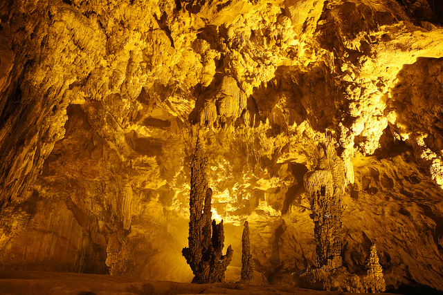


5. Culture
5.1 Cuisine
Cao Bang is a land of cuisine, with the distinctive taste of the mountain and people’s warmth. Hot rice roll soused with bone broth and sour noodles are some examples of Cao Bang’s cuisine. Rice roll and noodle in Cao Bang have typical tastes that are different from those in other areas. The rice roll is leathery and has delicious smell because it is made of Cao Bang’s high quality rice; it is also mixed with the bone broth cooked with chili, bamboo shoot, Vietnamese curry and cardamom fruits. Sour noodle is more difficult to make, because it is a harmonious mixture of noodle, cassava vermicelli, sweet potatoes, ground pork and some pork fat, fried pig stomach shredded into small pieces; the dish is then soused with chili vinegar and peanut.Cao Bang cuisine is also famous for dishes made from pork, such as pork marinated with sour rice flour in Bao Lam and Bao Lac, grilled pork or pork rolled in Vietnamese curry leaves in Quang Uyen, roast duck, and roast pork stuffed with Vietnamese curry leaf. The Cao Bang people skillfully combine diverse sources spices from the forest to create many special delicacies such as bees fried with bamboo shoots, sour fish hotpot, aromatic black diamond-shaped sticky rice, fried Tau Quay “stone moss”, chestnut green sticky rice, sweet short cake etc. These dishes are often enjoyed with Lau Pang wine of Ha Quang district (the wine is distilled from the powder of perennial arenga pinnata on limestone mountains, fermented by agarwood fruit. The powder is kept underground for a month, and when autumn comes, it is taken out to be coated in the dew before being distilled).
Trung Khanh Chestnut
Trung Khanh chestnut is a famous specialty in Cao Bang. Chestnut (local name is “mac lich” which means seed of nut). In the chestnut season (around end of august every year – in the Lunar Calender), the chestnut rustles throughout the forest, falling down, like a rain coloured in brown, on the ground covered by green moss, soft like velvet. Trung Khanh chestnuts are like a big toe, when roasting them, the flavour is delicate, sweet and nutty, making people who have tasted it cannot forget the heaven like flavour, even just one bite. The fruit is covered by sharp spines like rambutan, each of them contains three or four dark brown seeds.
When it is peeled and not be boiled, the meat is hard, crunchy and sweet with the colour is like canary bird. The fruit can be boiled, steamed or roasted then peel the skin to eat. If it is the first time tasting Trung Khanh chestnut, people will be surprised at its sweet and nutty flavour. After eating it, people can get a good sleep, forgeting the stressful life and the next moring waking up in full state, readying for a working day.
Collecting chestnut in forest (Trung Khanh, Cao Bang)[5]
In The American Journal Of Clinical Nutrition, it is said that chestnut can reduce LDL (bad cholestrol) for people with high LDL. The LDL falls down by 9% in the first month then by 12% in the second month after people with LDL add chestnut in their menu. The research also confirms that the fruit will not affect HDL, a good cholestrol. Certainly, the chestnut can be used to cure people. At the moment, the brand of Trung Khanh chestnut has been all over the North of Vietnam and even China.
Tra Linh Mandarin
Tra Linh mandarin is a favourtie specie of mandarin. It is planted from a long time ago in Quang Han Village because the soil here can give better quality and capacity. People like it because of the sweet that it only has, less sour, higher nutritions, watery and the beautiful shape. Its price is higher than other species of mandarin.
[6]Today, Tra Linh District has around 60 ha of mandarin, being planted mainly in Quang Han Village and be spreaded to Cao Chuong Village, Lưu Ngoc Village and Hung Quoc Town. Local people have already known intensive agriculture, by strictly following the techniques of growing the fruits, the mandarin make it uses, bringing in 200 – 300 million VND/season income, a lot of family got out of poverty, taking steps to be richer.
Sour Phở of Cao Bằng
The sour Phở of Cao Bằng is definitely held the limelight spot of Cao Bang culinary. One of the best dishes in Vietnam, Cao Bang Phở is a cool, flavorfully abundant and it is suitable to eat during autumn or summer. Used to be served in special events, the sour phở is now served as breakfast.
Sour Pho – Cao Bang[7]
Cao Bang phở is special thanks to its rice vermicelli’s softness, the fleshy of the livers, the fat of bacon, roasted duck, the spicy of chili, the extra fat of peanut, and the aroma of the pork’s intestine. In the summer time, it is good to have the sour of the sauce. The first time, you may find it peculiar, but the next time, it is nothing but delicious.
5.2 Craft village
Lung Noi traditional handy craftLung Noi Brocade weaving village, Phu Ngoc commune, Ha Quang district – one of cultural heritage located on the Northeast route – Experience history and Freedom. This is one of the tourist stop that visitors can understand more about cultures, history, faith and traditional practice of local people. Brocades are typical weaving and sewing products of Tay people in Cao Bang province. Brocades of Tay people are very well-know for colorful, eye-catching, traditional patterns which was passed from generation to generations. Brcades in Cao Bang are popular and quality brocade weaving products can be found in communes such as: Dao Ngan, Phu Ngoc (Ha Quang), Dan Chu, Duc Long and Nuoc Hai town (Hoa An district). Typical color and patterns of brocade weaving products of Tay people in Lung Noi, Ha Quang. The major ingredients for brocade weaving are indigo-dyed cotton yard and dyed silk. Particularly, there are 6 main colors on a Brocade of Tay people including blue, red, yellow, purple, white, black. From these main colors, the weaver concocted strong and light colors depending on the type of each product idea. The arrangement of patterns on brocatelle is various, resulting in special and different products. Typical patterns adopted in Tay’s Brocade usually are images of flowers, birds, animals …, which are very close to their daily lives, then mixed with clouds in the sky, mountains and rivers. These details make Tay’s Brocade of Tay people in Cao Bang different from Brocades of Tay people in other locations.
Typical color and patterns in the Brocade weaving products of Tay people in Luong Noi village, Ha Quang, Cao Bang.
Till now, Luong Noi village in Phu Ngoc commune, Ha Quang district is the only area that still retains this traditional brocade weaving of Tay people. The woman in the pictures above is Mrs. Nong Thi Thuoc has maintained this tradditional practice for 4 generation and she is the first brocade weaver of Tay people who was awarded the tile of “Golden award for Vietnam traditional craft family” by the Vietnam Craft Association on August 27 2016.
Phia Thap incense village
The incense making craft of the Nung An people in Phia Thap has a long history. Although no one knows the founder of this traditional craft, incense making has been inherited from generation to generation, creating work that is well known for every villager.
Drying the incense.
Phia Thap incense is made entirely from natural materials in karst regions, including: Bamboo trees (“may muoi” in Tay language) for making sticks, bark of bombax ceiba tree, and sawdust and especially leaves of the wild tree named “bau hat” to make glue for bonding the materials together.
Making incense is not difficult but it must go through several stages. Bamboo tree is cut into pieces of about 40cm long, split into small bars in the size of a chopstick and then tidily polished. The “bau hat” leaves and barks of the bombax ceibatree are well milled and mixed with sawdust. Apricot sticks are soaked in water that is mixed four times with powdered “bau hat” leaves to create a glue, then seasoned with flour mixture of “bau hat” leaves, bombax ceiba bark and sawdust to create incense sticks. After drying, the sticks are dyed red at its bottom half and dried again, before being tied into bundles to sell at fairs. Making incense not only brings income to the Phia Thap villagers but also contributes to preserving a traditional craft of the Nung An people. It is a beauty imbued with national identity associated with the custom of the Vietnamese to worship via burning incense in the Non Nuoc Cao Bang Geopark.
Phuc Sen forging village
The Phuc Sen forging village is located at Phuc Sen Commune, Quang Uyen District, Cao Bang Province. It is said that this village was established in the 11 th century. In the early days, the villagers produced weapons for the soldiers of Nung Ton Phuc and Nung Tri Cao to fight against the Song army. After the war, they made farm and domestic tools such as ploughs, hoes, knives and scissors. It is also said that the villagers used to cast cannons and grenade casings, especially during the resistance war against French colonialism. Thus, this craft village has a long tradition of forging. There is also another tale explaining the origin of this craft village. It says that from ancient times, there was an old, strange-looking man walking through the village. He noticed that the local Nung An people lived only by hunting, hence they were always poor. However, the old man found that the local people were very kind, and they had extraordinary bright eyes because they could walk in the forest at night without any lighting equipment. Therefore, he decided to train the Nung An people how to forge tools. Following that, the old man left Phuc Sen without saying goodbye to anyone, and no one ever knew his name or address. Today, the Nung An people in Phuc Sen have established a temple to commemorate their ancestor. Every family has its own incense bowl to express their gratitude to the ancestor, who brought the craft to the village and improved their lives.
The family of Nong Van Loi in Pac Rang Hamlet, Phuc Sen Commune perform the traditional blacksmith craft.[8]
Currently, Phuc Sen village has nearly 400 families, all being Nung An people. More than half of the households are engaged in forging, so the village has become the largest “forge factory” in North Vietnam selling different kinds of knives, swords, broadsword and production tools. Many families have practiced forging for tens of generations. The forging products of the village are famous for their sharpness and durability, and are sold throughout the country as well as being exported to China. The people of Phuc Sen village say that the way they forge a knife is different from that of the Kinh people. Before they make the shank, they have always forged the knife blade until they are satisfied with the sharpness. It implies that the quality of the product is more important than the appearance. They have an innate ability to sense the steel so that products are durable but not brittle, and flexible but not soft. The water to harden steel is prepared using secret methods by each family. Usually it is a mixture of lime water with charcoal ash of ironwood that is left overnight before use.
There is a plausible feeling that perhaps Phuc Sen forging village is fortunate to have inherited the essence of the brilliant Dong Son Culture that is famous for bronze arrows in the time of King An Duong Vuong. However, thanks to the natural conditions of the karst forests with an abundant source of minerals such as iron, tungsten, tin, and copper, and the skill, wisdom and diligence of the Nung An people, they were able to develop the sophisticated products.
Belonging to the Phuc Sen commune are other handicraft villages, making e.g. Poonah paper, incense. Thế Pác Rằng community tourist village in this commune is also doing well. The Phuc Sen forging village also has some geoheritage values such as Crinoid fossils in limestone of Bac Son Formation (C-Pbs), peak cluster-depression landform, karst field, and triangular facets on limestone cliff as evidence of fault activity.
Garments
The most popular costumes in Cao Bang are of the Nung and Tay’s that are made from simply-decorated indigo-dyed fabric. The Dao’s garments are more colourful and diverse, including two types, which can be identified by their black trousers embroidered with flower or small star patterns. The garments probably express their different perceptions of the world. While the Tay and Nung people want to live at peace with the nature, the Dao people try to indicate that they are the owners of the place by wearing chunky high-sounding silver jewelry on their necks, hands and waists.
The Tay men’s garments include an indigo-coloured long dress, white trousers, a turban (the top of which slanted backwards) and cloth-made shoes. The Tay women wind the plait of their hair horizontally and cover it with a square kerchief. They wear an indigo-dyed long dress with bronze buttons on the right and an indigo cloth belt the two ends of which are let straight down on back. The Tay people themselves weave and dye their indigo cloth. The garments of the Nung people are more diverse than those of the Tay people; however in general, the main features are similar. The Nung women’s shirt has a collar and large sleeves decorated with bright multi-colored cloth pieces with indigo still as the major color. The Dao ethnic group has various types of clothes, which have distinctive features. The main Dao branches in Cao Bang are Dao Tien (Coin Dao) and Dao Do (Red Dao). The Red Dao women wear splendid garments made of black material embroidered with red cloth pieces. The 8-si kerchief (Ca pha) is wound around their head, looking like a flat hat. Their sides are covered with cloth bands (pha xi) decorated with a number of embroidered motifs in red threads. Their belts (xi lo chin) are embroidered with sophisticated motifs. Their shirts have long taps and hemmed sleeves. They open on the breasts to reveal the light-coloured bras with two strings of eight tassels (nom lang gau) each inside. Their large-legged trousers (hau tao) are decorated with green, red, brown or white squares. On their backs, there are material squares (nom kie) skillfully embroidered.
Red Dao and Coin Dao garments[9]
5.3 Festival
The lunar July Full moon festival and the traditional custom “Pây Tai-visit wife’s parents” of Tay and Nung people in Non nuoc Cao Bang UGGp.One of the significant values of Non nuoc Cao Bang UGGp is cultural heritage. Tay and Nung people living in Non nuoc Cao Bang UGGp posses distinguished custom, which is of cultural identity and really human. “Visiting wife’s parents” is a traditional custom of Tay and Nung people, it is usually practiced on the 2nd day of the Lunar new year and on the the lunar July Full moon festival.
“Visiting wife’s parents” on the the lunar July Full moon festival is the responsibility of the Tay and Nung women after they get married. All year round, they spend time with their own family and work at their husband’s house or their own houses and take care of their husband’s family. In the year, only on the 2nd day of the Lunar new year and on the the lunar July Full moon festival do they have time to visit their parents and present their gifts to their ancestors. In addition, in the Tay and Nung people also celebrate the “Ghost Festival” as other Kinh or (Vietnamese) people. They also prepare their “gratitude-to-parents or their ancestor” gift, which is similar to the Ghost Festival in Buddhism.
On the lunar July Full moon festival (Ghost Festival), the daughter and son-in-law and their children usually visit their parents in the early morning and bring with them gift for the parents, which will be incomplete without a pair of ducks to show their gratitude to their parents and ancestors. Once they arrived at the wife’s house, gift will be placed on the altar with lighted incense, then people will prepare the duck together to make traditional dishes from duck.
One of the most typical dish from duck of Tay and Nung people is roast duck. The duck, after slaughtering, will be marinated with local spices such as the leaves of Clausena indica tree and coat its skin with a thin layer of honey bee, then it will be put in the oven. Now the roast duck of Tay, Nung people has become a special dish. Tay and Nung people have some sayings about their food traditions such as: chicken is for the lunar New Year, duck is for lunar July Full moon festival. According to their tradition, the duck is belived to be one of the sacred animals because they belive that the duck is the ambassador from the heaven. On the On the lunar July Full moon festival (Ghost Festival), the duck will escort the rooster through the sea as a gift for the gods. (Theo Báo Cao Bằng)
Some spring festivals in the Eastern route of Non Nuoc Cao Bang Unessco Global Geopark
Apart from geological, bio-diversity, and historical heritage, intangible heritages of Non nuoc Cao Bang UNESCO global geopark has made up particular and exception significance of a UNESCO global geopark, especially the Sung Phuc pagoda spring festival and Phao Hoa cracter spring festival in Quang Uyen district.
Dragon dancing in Cracker spring festival.
*Sung Phuc pagoda spring festival
Sung Phuc pagoda spring festival, located in Huyen Du village, Thanh Nhat commune, Ha Lang district. The pagoda, built during the Tran dynasty, is located in the rectangular shape campus in the Norther-South direction. The pagoda, which closely associated with buddihsm, is accommodated with the statue of the Bodhisattva in the harem. While Thanh Hoang shrines, which is located in the campus, was built for worshiping Nguyen Dinh Ba- A Sennior integrity officer, who was highly respected by local people. In addition, the pagoda is also used to worship Dr. Nguyen Thi Due, who practiced Buddhism for 6 years in the Pagoda with the nickname of Huyen Du. She also taught Buddhism to people and was highly respected by local people, people also named this pagoda as Huyen Du pagoda. This pagoda was ranked as the provincial level monument in 1993.
Untill now, the Sung Phuc spring festival is organized annually on January 15 (lunar calenda). For the ritual practice, the organizing committee and local people first put the insence on the altar to show their respects to the Bodhisattva and thank for her protection for peace, security, happiness, and prosperity
The ritual practice will be followed by lots of festival activities and traditional games such as pushing stick, tug, chess, etc. Particularly, the exchange of traditional love songs such as Ha Leu, Luon Then, Nung Khen, ect among young couples which is usually an attraction to people of all ages in the Festival. In addition, Chinese people who are living near the border area of Ha Lang district usually come to join the Festival.
*Phao Hoa (cracker) spring festival in Quang Uyen district
The Phao Hoa Spring festival in Quang Uyen district is organized annually in February (lunar calenda) in some areas of Quang Uyen, Phuc Hoa, Ha Lang and Thach An district. The Festival, celebrated in Quang Uyen district, is organized annually on the February 2nd (Lunar calenda).
Before the festival comes the ritual practice, which is celebrated from the afternoon of the previous day (February 1st). The organizing committee of the Festival and local people come to the Bach Linh shrine, which located at the entrance of the town to present their offerings and pray for good luck, prosperity and protection from the god. Bach Linh was built for the worship of more than 100 sacred gods, which has been its sacredness, on the top list of these sacred gods is the dragon, one of the most four most sacred god with magic power.
The next morning February 2nd (Lunar calendar) will followed by the procession of palanquin of local gods, then the cracker, and the palanquin with the roasted pig and lastly the procession of the dragon. Nowaday, people also use the palanquin with picture of uncle Ho to lead the procession. The practice of god procession started from the Bach Linh shrine to Nung Tri Cao Bang temple, which dated back to the Tran Hung Dao dynasty. The procession delegation escort the palanquins through the town, public offices, households with the aims to bring gods to visit local people and give them good lucks, and people are really happy and excited to receive the procession delegation.
The festival activities are organized in the afternoon of Febuary 2nd, especially the cracker game. This is one of sport game which promotes and requires physical health and the combination of skill and spirit, assert, activeness, knightliness, great-heartedness of young people. The organizing committee will gather the young males circling the center of the game; the one who get the wreath hung at the head of the cracker is believed to have good luck and prosperity in the year. The award for the winners will be the roasted pig and the head of the roasted pig will be reserved for the one who got the wreath. On this day, almost all household will make 5 color sticky rice and roasted pig, one of the most special dishes in the Festival together with other local snacks and drinks. Visitors to the Festival might be entertained with dragon dancing, football, the exchange of love longs of young couples, and traditional games which help to make up a distinguished traditional Festival of local people.
The Cracker festival in Quang Uyen is one of the most interesting one in Cao Bang and attracts lots of visitors. In addition, Quang Uyen district locates in the center of the region and in a favorable position connecting to other main transportation routes of eastern districts, which ease the travel of nearby people. (by Lê Chí Thanh)
The village of Tay ethnic group celebrating Lunar New Year
Tay is the one of the most populous ethnic group living in Non nuoc Cao Bang UGGp. Their main settlement area is near the rivers like Bang, Ky Cung, Cau, Gam and Chay, etc of Cao Bang, Lang Son, Bac Kan, Thai Nguyen, Tuyen Quang, Ha Giang, Lao Cai, and Yen Bai). They live in a big community or village with at least 6-9 household. This is the reason why other ethnic groups are influenced by tradition, practices and even language of Tay ethnic group when they join Tay community. In contrast, because of the cultural exchange with other ethnic groups, Tay ethnic groups are also impacted, backward practices were removed and traditional values are preserved and updated with new and proper practice of the modern society, including the Lunar new year, which is also the main festival of in a year of Tay people.
Tay ethnic group prepare very carefully for the Lunar new year. Before the first day of the Lunar new year, the Village of Tay ethnic group is busy preparing for the festival such as : Ginger cake (pẻng khinh), green bean cake (pẻng dỏ thúa), sticky rice flour bar cake (sa cao), cooked sticky rice flour (chà lam), fried sticky rice mixed with sugar (khẩu si), etc and pop-rice mixed with sugar ‘Thuc Thec’, in which Khẩu si ís the hardest one to make because of different steps.
The village is busy with the sounds of sticky rice grinding to make Banh Day. Rice noodle is one of the main food for the Lunnar new year, first people will soak rice in water, then grind the soaked rice to get the water flour and pour this water floor into a bag to seperate the flour and water. Normally, three or four household would share one pig of about 100kg, and pork would be prepared before the Lunnar new year. The insence and fake paper money are bought and prepared before the New year. Chung cakes are wrapped carefully in pattern, the green color of the cooked Chung cake is decided by the front side of the wrapping leaf ; there are two types of the inside of the Chung cake, one is sweet and the other is salty. Particularly, each household perpare a pair of big Chung cake considered as the Parents cake with the best inside (normally fat pork, green bean, sweet potato, cane juice sugar, moutain ginger, etc)
In the afternoon, people would gather their cattles back home. On the last day of the old year, people would cook Chung cake for the whole day until night time (about more than 10 hours) ; family members take turn to take care of the Chung cake, and each member would have a shower with Pachira aquatica leaf, it is believed that this kind of leaf would help people have smooth skin and stay away from skin diseases.
From 12 p.m to 1.00 a.m people would wake up to welcome the new year’s eve.
People would light the incense and put them on the altar which was cleaned before, the good smell from smoke of the incense would pervade through the house ; cakes and gifted are presented on the altar to their ancestor. The house owner would then pray for the protection and support from their ancestor for a new year with good luck and fortune. The incense is pitched at the gate of the house to guide and welcome the soul of their ancestors backhome; it is also pitched at the kitchen, cattles cages, etc. Their oldest child would bring a bunch of incense and a pair of bustket to the water well to pitch incense there and bring back home the lucky water. The village will be loudly wishing the best luck for the new year, especially at the water well or crystar running streams. School students would then sit at desk to read book so that they would get more intelligent, etc. For this day, the above mentioned preparation procedures have been shortened so that people can gather together and watch TV, etc.
On the first day of the new year, the Tay ethnic group would stay at home and enjoy the festival with each other. People would prepare the meal together like rice noodles, cake, chicken, ducks, etc.
Previously, Tay people paid serious concerns for the first foot on the first day of the new year. Though gender bias is not a problem in nowaday society, people are still not really happy with the women first foot. People used to choose the first step by considering the match of the year of the house owner and the first foot.
It would be perfect if their friends who live far away from their house comes to visit them for the first foot, but again they need to know the lunnar year of the house owner. Moreover, the Tay ethnic group tend to stay at home on the first day of the year but not visiting other friends’ house. Because they are afraid that they would pour their good luck to other house (vải dài). Once visit their relative on the first day of the new year people need to pay attention to the frest branch of tree, for some reasons if the house onwer might not want to welcome the guest at that time they would hang a branch of tree at the door (bâư phật).
On the first day of the New year, the household need to take care of departuring to pray for good luck and fortune, and deepending on their age, people would choose a suitable time and direction for departure.
A new trend of Tay ethnic group is that people gather and meet each other at the cultured house on the first day of the lunar new year (at about 9 a.m) to sing the national anthem under the flag and listen to the new year letter from the President, and the schedule of new year activities of the village and contribute to the awards of games.
On the second day the family would visit the wife’s parents. The wife and her husband, children would bring their presents to show their gratitues to the wife’s parents. The wife’s parents would give lucky money to children in red envelops.
The joint year games of the village would start from the early morning of the third day.
Tomb sweeping festival in Cao Bang
Apart from biological and ecological value of international significance, Cao Bang in general and Non nuoc Cao Bang UNESCO global geopark is famous for its identical and distinguished cultural values. Cao Bang is home to more than 95% ethnic minority groups with their own traditions and practices. It is their identical feature which has helped shape a colorful and cultural diversity picture such as traditional folk songs of groups such as Then, Ha Leu, SLI, LUON, and different traditional festivals such as Long Tong, Fire crackers, Nang Hai, in particular the Tom Sweeping Festival of Nung An people in Phuc Sen Quang Uyen, Cao Bang.
Tom Sweeping Festival of Nung An people is celebrated on the first day of the fifth solar term of the traditional lunar calendar, normally it is after the Spring Equinox, either 4 or 5 April (lunar calendar) in a given year, in Phuc Sen commune, Quang Uyen district. According to the people in there, this festival is celebrated to memorize and praise the faithfulness of a young couple with true love, ordinary and simple life and agaist backward and feudal practices. The festival is celebrated to pray for good crop as well. The name of this festival in Nung language is “Sinh Minh”.
Once upon a time, there was a young man named Sinh (Thanh) in Phja Chang valley, Phuc Sen commune, who was smart, good-looking, and strong. During his time, there was also young woman named Mình (Minh), who was very beautiful and gentle. They were both very hardworking, kind, and fancied by other peoples in their communities. They met and fell in love with each other deeply. Since Sinh (Thanh) loved Minh too much, he invited Minh to come to stay with him while they hadn’t completed marriage procedures according to their tradition. This was against their tradition in which their parents would arrange their marriage for them. Some of the people in their community commented that this doing was against tradition. Although people in the community knew that it was their true love. Meanwhile, in the region there was a greedy and perfidious official, he wanted to marry her as well. He tried to flirt, threaten and seduce her in order to get what he wanted. The young woman denied the wealth and gorgeous life promised to her and followed her heart love with the young man. The backward tradition and the perfidious official prevented their true love and this made them feel really sad. However the young man and woman still loved and stayed with each other. Time passing by, their lives became harder and harder. They felt so hopeless that they committed suicide; they jumped into the deep blue water area close to an old banian-tree where the young man and woman promised to love and stay each other forever. It was so strange that the water area turned into a fresh stream and wherever the water ran to, the area, trees and crop became fertilized, and local people had good livelihood and prosperous lives. It was said that this was owning to the protection from souls of Mr. Sinh and Ms. Mình, though they passed away, they still missed and loved their homeland. Since then people put an incense burner near the water area to show their gratitudes to the young couple; hoped that they would not be splitted up, and praying for good health, good crop. The people in the area chose the first day of the fifth solar term of the traditional lunar calendar to celebrate the festival and name the festival “Sinh Mình” “Tomb sweeping festival” to memorize their young couple Sinh and Minh (Thanh Minh). The old water area because of long time alluvion and accumulation was changed into the water well of Phja Chang village, near the Kindergarten and Primary school of Phuc Sen commune. Annually, on that occasion, young men and women in Phuc Sen commune still come to this area to look for their spouse and promise their love in there.
Once coming to join the festival, we will be aware of the presence of a temple near the People’s committee of Phuc Sen commune worshipping the Land God which dated back long time ago. Time passing by with historical events, the temple was deteriorated. After 1979, local people renovated the temple and roofing with Yin Yang tile, and developed a middle altar with ancestral tablet and two parallel sentences in Sino-Vietnamese. This is the place to hold the memorial ceremony to memorize the tragic love story, and for young couple to express their exception of love, while carrying out practice to express gratitude to the Land God to pray for good crop and weather. Most of Nung An family coming to join the festival always bring good food and fruits, wine, etc to present at the temple altar in order to show their respect to the young couple. After that, people start praying near the water well, where Mr. Sinh and Ms. Mình died. Thanh Minh festival (Tomb sweeping festival) is a traditional festival demonstrating belief, spiritual life and inclined to the good of Nung An people. In addition, it is suitable to the needs of spiritual practice of ethnic minority groups. This explains why people, especially young people enthusiastically sustain this traditional festival.
Nang Hai Festival
Nang Hai festtival of Tay in general and the Nang Hai festival in Tien Thanh, Phuc Hoa in the east of Non nuoc Cao Bang UNESCO global geopark in particular reflects the Mother worship religion of the Tay people in Cao Bang. According to the faith of Tay people, the Moon Mother and Fairies live on the Moon, they help to protect and secure properous crop for the people. The Nang Hai festival is organize to demonstrate the moon journey to receive and welcome the Moon mother and Fairies down to the earth to visit field, homes and experience daily life of the people and help people on the earth with good life, crop and properous business.
The Nang Hai festival in Tien Thanh commune with community based performance is typical among festivals of Tay people, which includes all the three parts namely praying for good crop, happiness and love. In nature, this Festival reflects the Mother worship faith through typical ceremony soul extraction – a phenomenon of Shaman religion.
In Cao Bang, there are other areas that are celebrating Nang Hai festival as Phuc Hoa district such as Thach An, Bao Lam, Bao Lac, Trung Khanh and they also include the Three parts. However, the Festival celebrated in Phuc Hoa is the most special one, which demonstrates history that related to the Mac dynasty in Cao Bang. Currently, in Phuc Hoa, there are some areas celerbrating Nang Hai festival including Nua Khau, Bang Giuong, Nguom Cuong, Ban Chap but these are fading away, only Ban Nua Khau usually celebrate Nang Hai festival in even years (lunar calendar).
Nobody is sure when this Festival has been being celebrated, it is know that this started since farmers wanted to send their wishes to a Fairy, in this case the Moon mother. However, as mentioned above this Festival also related to the existance of Mac dynasty in Cao Bang. Till now, there is a folk saying about a moved love story between the General Dinh Ta Van and a girl-who is belived to be the Mac princess and this girl characster is the inspiration for the choral singing performance in the Nang Hai Festival in Tien Thanh Commune, Phuc Hoa district. As being known that, the Mac was considered the Dynasty of usurper, existed for about 150 years. The recorded history of Mac dynasty in Cao Bang is very little, information is not enough and precise, especially the last years of Mac Dynasty. Based on the historical evidents, folk tales, and remnants, we can inteprete about historical events relating to the existances of Mac Dynasty in Cao Bang province and its influences on the contemporary Nang Hai Festival in Tien Thanh, Phuc Hoa, Cao Bang. According to the recent survey, it can be intepreted that this Festival was started in Tong Lao (Tien Thanh commune) then dissemniated to other areas. Owning to the General Dinh Van Ta and the Mac princess, this Festival has been celebrated with more associated meanings. From the activities in the Festival, we can easily see the connection between the daily life and faith of Tay people. For farmers, their best concern is favorable weather and good condition, healthy castles, etc which are all demonstrated in Nang Hai festival.
In addition, Nang Hai festival reflects good practice of traditions of Tay people. Community union and respect are nice behavior in culture of Tay people. The Nang Hai festival has helped encourage and maintain these practice. This is a days, community-based performance festival, not yet including consensus among the community before and during the celebarion of the Festival. For such a Nang Hai festival, it requires efforts, consensus, and solidarity of Community. The Festival is an opportunity for to build friendship and love among community members. The build-in holy solemnities of the Festival help to maintain the neat and order from the commencement till the last moment, which is also a symbol of community repspect of Tay people. Elderly repsect and taking-care children are another nice traditional practice of Tay people. In the Festival, Elderly is the one who make decisions. They play the important characters of the Person who guided Nang Cuong, acted in the roles of So and the Mother-who is usually very knowledgeable and respected character, besides the voice of the young is heard and they are guided by old people too. Actress in The Nang Hai festivals now are young girls and are guided by the old people. Another humanism values should be mentioned here is the freedom in marriage of Tay people. The Festival lasts several days, with the tradition of inviting friends coming for exchange of songs is a good opportunity for men and women in other villages to meet and date. Hospitality is a good tradition which demonstrated in the Nang Hai Festival. It is believed by Tay people that the more hospitable families are, the luckier they are. Nang Hai festival is a friend reunion day with open stories from bottom of their hearts. This traditional practice should be kept and maintained. Nang Hai is a choral singing performance festival that is not very popular in other Festivals. As initiated by the inspiration of the Festival, the couple-singing lyrics are very humane. Words used in songs are very descriptive with flexible performance. Furthermore, the Praying for good crops songs contained a sum of vocabularies of Tay language, which help researchers understand more about the development process of this language. Though dancing performance in the Festivals is not popular, it warms up the atmosphere of the Festival. The combination of dancing with traditional songs makes the Festival very attractive and lively. In addition, the attraction of the Festival also includes other types of cultures such as: arts of decoration of the Festivals, wooden board carving, painting, and especially the art of food presentation, and craft gifts, etc which added by the colorful flower given to Nang Hai, the beauty of costumes of Cuong, So, fairies and the Mother. It can be said that apart from the spiritual belief practice, visitors to Nang Hai festival in Tien Thanh commune, Phuc Hoa district might be able to enjoy the creativeness of arts. This Festival gradually regarded as the typical community and cultural practice of Tay people in general and Tay people in Tien Thanh commune, Phuc Hoa district in particular. With outstanding historical and cultural values, the Nang Hai festival of Tay people in Tien Thanh, Phuc Hoa, Cao Bang province was listed and awarded the certificate of National intangible heritage in the Decision No 2459/ QĐ-BVHTTDL by the Ministry of Culture, Sports and Tourism on July 20th 2017. Besides, there are many other festivals hosted in Cao Bang: Long Tong Festival; King Le Temple Festivals; Quang Uyen Fireworks Festival.
5.4 Legend
Legend of “Cau chua cheng vua” (Nine lords struggling for the throne)The legend of “Cẩu chủa cheng vùa” is about the establishment of Nam Cuong State under the rule by King Thuc Che and his son Thuc Phan, who later became the king of Au Lac State and moved the capital to Co Loa in present-day Hanoi’s Dong Anh District. On the other hand, the legend authentically describes the land of Cao Bang, with a flat valley in the center, surrounded by ranges of mountains. A series of places in the ancient Ban Phu Citadel were also described through the legend, reflecting the perceptions of the ancient people about natural landforms.
According to the legend of “Cẩu chủa cheng vùa”, the land of ancient Cao Binh was located along two sides of the Bang Giang river with Hoa An basin at the center. It includes 10 regions (9 villages and 1 center). The center village was ruled by Thuc Che, with title of An Tri Vương, who established Ban Phu Kingdom and the capital Nam Binh. Surrounded the other nine regions were vassal states governed by the lords named: Tien Dat, Kim Dan, Van Thang, Ngoc Tang, Thanh Giang, Quang Thac etc. They together established the Nam Cuong State, which was contemporary with Van Lang State of Hung Kings and the Lac Viet people in the south. Thuc Che reigned for about 60 years and died at the age of 95 when his son Thuc Phan was only 10 years old. The nephew of Thuc Che, named Thuc Mo, helped Thuc Phan to become a regent but as he abused power, all nine regional lords were disobedient. They pulled troops to the center in order to force Thuc Phan subdivide the national land, and asked him to abdicate the throne of “the king”. However, Thuc Phan was very smart at such young age that he organized talent competitions with promise to cede the throne for winner.
The talent competitions were organized with stratagems. They were all very difficult and time-consuming, such as shooting falling banian leaves, making 1,000 needles from a plowshare, and even with “beauty trap” by assigning 10 beautiful young ladies to accompany the competitors etc., consuming much of time and effort. They were so hard that none of the competitors could complete their exams and therefore the lords had to submit to King Thuc Phan.
According to the legend, Ban Phu Citadel was located on a large area surrounded by rivers and fields in the nowadays Hung Dao Commune, Cao Bang City. This was the imperial court of the Palace during Thuc Che-Thuc Phan Dynasty and even the later Mac Dynasty. At that time, the military castle was based in Na Lu (the present-day Hoang Tung Commune, Hoa An District).
Ban Phu Citadel was built in a very beautiful location that faced to the Southeast. At the front of the Citadel was a 7ha-wide lotus lake and Cao Binh Plain, followed by the Tong Chup field. The field was initially called Tong Quang field to infer a large field, but later the name was changed to Tong Chup to refer to a story about the competition of Tien Dat Lord, who could not complete cultivating the entire rice field leaving an area “as tiny as a hat” unfinished. Close to the foot of the inner wall was a jade well (now called Bo Pho) that had clear water for all year round. Near the Lotus Lake were the Giao and Thien Thanh temples, which were rumoured as the places where the King worshiped the God. On the right and left sides of the wall was Peach garden (Dao Vien) of the Queen’s palace, namely Dong Tam, next to the resident place of maidens. The upper part of the hill, namely Thom Dang, was used to raise elephants. The kid area was called Ho Nhi or kid’s lake. Near Ban Phu, there was an ancient banyan, which was a place where Kim Dan Lord used his bow and arrows to shoot almost all the falling banyan leaves. Out of the outer wall, near Dau Go, there was a pair of giant stone clogs incompletely perforated to pierce straps, as a result of Van Thang Lord’s competition. Riding about one more kilometer along Highway No. 4, on the right side of the road appeared a hill called Khau Lua, i.e. boat hill, which tells a legend about the boat that Ngoc Tang Lord had yet to complete turning upside down. Opposite to Khau Lua, on the other side of Bang Giang river bank was Na Lu Citadel (with the King Le’s temple and festivals celebrated annually on 6th lunar January), which still lack a gate, as an unfinished work at the talent competition by Thanh Giang Lord. The other lords competing to write poems or make needles all failed because when the contest was almost completed, they heard the drum sound of Quang Thac Lord and supposed that he had won. In fact, Quang Thac also failed due to the “beauty trap” of Thuc Phan that dropped his drum rolling down the abyss and made echo of the noise. The place where the drum rolled down was named as Tong Lan.
6. Archaeological values
Early Neolithic relicsRelics of the Hoa Binh and Bac Son cultures date from 17,000 to 7,000 years ago, associated with the Flandrian Transgression. Relics are found in such caves as Nguom Boc (Hoa An), Nguom Cang (Trung Khanh), Hang Na Con (Nguyen Binh), Nguom Chieu (Quang Uyen), and on the terrace of the Binh Long river (Hoa An), as well as in some other caves outside the Geopark, such as Nguom Cang, Nguom Vai, Hang Than (Thong Nong district). Stone tools found of moderate size, manufactured from river and stream gravel using rudimentary flaked or simple blading techniques. Studies of occupation and settlement sites suggest:
– Although limestone valleys and caves were home to most of the inhabitants of this epoch, in the northeast mountainous areas hilly terrain and river terraces were also favoured for settlement.
– Preferred hunting and gathering areas were lowland and mountain river valleys, and forests.
Nguom Boc cave (Hoa An)
Nguom Boc cave monument is in the territory of Ban Nua commune, Hong Viet, Hoa An district (coordinate: 617256, 2511578); It is a national revolutionary historical site about 2km to the north of Hong Viet commune center. At this place on October 1950, President Ho Chi Minh generalized the Border Campaign. (Nguom Boc means Dry Cave in local language). In the famous Pu Luong – Sao Cai legend of Tay – Nung people, it was the first residence of the two aforementioned legendary figures in Cao Bang. The cave distributes in the western slope of Lam Son Mountain with a large dome-shaped cave mouth opening to the west and an area of about 300m2, divided into two large chambers. The first chamber is located and the second chamber has 2 stone pedestals which were built by cement and relatively big. These are the vestiges of machine pedestals of a military weapon workshop in the 1950s.
The relics include:
+ 3 rudimentary chopping tools, 1 Hoa Binh-style oval tool, 2 scraping and cutting tools, 2 grinding pestles, 3 material pebbles; all were processed from pebble stones in rivers and streams by simple flaking and chipping techniques. The tool shapes are typical of Paleolithic nuances. Nguom Boc collection does not contain Son Vi technical characteristics but processing in Hoa Binh style is still fuzzy.
+ The presence of a sediment block which is more than 1 meter thick and densely containing stream shells suggests they were food remains of the prehistoric man living in a rainy period with the development of aquatic species. Based on C14 analysis of stream shells in the sediment (results: 7.420 +-95 yn and 6.820 +- 95 yn), archaeologists have predicted that the layer of archeological site dated back to about 10,000 years ago(there are still approximately 10m3 of sediment containing stream shells and tools, distributing along both sides near the cave entrance).
Based on the overall research on archaeological relics, colors and compositions of sediment and fossilization levels, archaeologists assumed Nguom Boc is a resident relic of the primitive people living at the beginning of the Holocene period about 10,000 years ago, equivalent to the period of early Hoa Binh culture.
Nguom Cang cave (Trung Khanh)
Nguom Cang cave monument is located in Ban Gioc, Dam Thuy, Trung Khanh district. Coordinate: 675737, 2528391; It has a dome-shaped entrance with approximately 15-20m width, ~10m height, many stalactites hanging, facing the north. There is a karst valley in front of the cave. The ancient karst cave floor is about 3m above the field surface. The cave is quite wide with an area of about 300m2; a small niche penetrates into the cave in the southern part.
Archaeologists have surveyed (May 2001) and preliminary discovered 23 stone relics of the primitive people. In particular, 7 templates were found on the surface and 16 artifacts were in the cultural layer, including rudimentary chopping and hitting tool (horizontal blade edge), flake tools, flaking and hitting stone, flakes, and pebbles with flaking traces.
Most of the relics were processed from pebbles. It is likely that Nguom Cang residents found pebble source in Quay Son River to make tools. Flaking and chipping techniques were simple, direct and limited on one side and on the edge of pebbles. Tools have an ancient look; formativity in tool shaping technique is low; and forms of tool typical of the Paleolithic traditional culture are not diverse. There is no grinding stone and pottery. These remains show gathering had a particularly important position in the methods of searching for food sources of the primitive people [6]. Based on processing techniques, types of relics found and sedimentation level of the cultural stratum, archaeologists initially assumed Nguom Cang is the residence monument of Stone Age people in the early Neolithic period.
Nguom Cang cave (Thong Nong)
Nguom Cang cave is located in Vi Quang commune, Thong Nong district (outside the Geopark) (Nguom Cang means Gibbon cave). Nguom Cang is essentially a stone roof distributing over the steep slope of a limestone mountain – limestone slope and wall are vestiges of NW-SE tectonic fault. The height the wall foot up to the cave entrance is about 50 meters; there is a tectonic valley in front of the cave entrance and Thang Lat stream along the valley. Nguom Cang monuments include:
+ Monuments (3 types)
– Fire monument: a greyish white ash layer with uneven thickness from 2cm to 4cm has been discovered. In the coal ash was burnt shells and some broken animal bones.
– Animal bone, tooth monuments are identified as of deer, pig, goat, monkey, bamboo rat, chicken, bird, porcupine etc. Notably there is a piece of pig jaw with burn marks, indicating they are the remains of the ancient food. Most animal bones and teeth have not fossilized.
– Mollusk shell monument: more than 30 stream shells with traces of cut penultimate whorl and many crab pincers.
+ Stone relics:
– Group I: the group of traditional tools with significant amount: 41.19%, including spike tools, horizontal edge tools, vertical edge tools etc. This relic group is classified as typical tool group of Son Vi culture of the late Paleolithic period. However, when examining, archaeologists also found differences between the traditional tool group in Nguom Cang (Thong Nong) and Son Vi tools in Lao Cai, Phu Tho, Yen Bai, or in the Northwest area. Analysis of processing technique also found differences between the traditional tool groups in Nguom Cang with Son Vi tools, typically in processing types of vertical edge chopping tools, pebble quarter tools etc.
– Group II: The group of tools of Hoa Binh – Bac Son style takes up of a large proportion in Nguom Cang: 16.05%. They represent the rich and stable Hoa Binh techniques in a number of specific forms, including oval tools, disc-shaped tools, short axes made from unbroken or broken pebbles and mainly having a side flaked by radial flaking technique – Sumatralith technique. Statistics show the majority of Hoa Binh featured tools in Nguom Cang is oval axes (Sumatralith) and short axes. Notably in Nguom Cang collection is “Bac Son trace” relic. The appearance of this relic is likely to be the hallmark of the cultural communication between Hoa Binh inhabitants and Bac Son culture inhabitants. A rather common technique in Nguom Cang is the flaking technique with limitations in pebble edges on one side and in one direction – creating rudimentary chopping tools or spikes. This is a fairly old technique, popular from the Paleolithic and typical of Son Vi culture – a late Paleolithic culture in our country.
Another typical flaking and chipping technique in Nguom Cang is radial flaking and creating forms of Sumatralith tools with oval, dish shape, short axes etc.
A notable technique is grinding technique in Nguom Cang relics – this is a revolutionary factor in the primitive techniques. It completely changed the appearance of flaking and chipping tools which were familiar in millions of years and improved the productivity of the tools.
+ Production methods: Researches on archaeological sites show hunter-gatherer mode is a remarkable feature of daily life of Nguom Cang residents. Whetstones and grinding pestles are vivid evidence of processing food from the flowers, fruits, bulbs and roots of ancient residents here. A large number of spring snail shells found with traces of cut penultimate whorl prove they are an important part of the ancient human food supply. Nguom Cang residents had a rather broad relationship with contemporary residents instead of living in isolation. Studies on stoneware here show that the oval tools, short axes in Nguom Cang are quite similar to the tools of the same type in Ha Giang, Tuyen Quang.
+ Determination of age: Overall research on monuments and relics collected in Nguom Cang cave indicates it is a monument of the early stage of Hoa Binh – Bac Son culture, early Neolithic culture dating back to approximately 8,000-9,000 years ago.
Bang Giang River terrace, Bo Ma village, Hoa An
In the terrace area in Hoa An district, a monument of prehistoric man was discovered (December 2010) distributing in the high ground of Bo Ma village, Hung Dao commune [14]. Here on the avalanche talus and hill slopes which were originally the ancient alluvial layers of terrace level II of Bang Giang River exposed a stratigraphic section containing archaeological relics, mainly flaking and chipping tools interbedded in conglomerate sheets, under a nearly 1m thick layer.
The relics found include spearhead tools (3 units), rudimentary chopping tools with horizontal mounting blade edges (14 products), vertical edge tool (1 artifact), and tool with 2 adjacent edges (2 artifacts).
The tools are made from river pebbles taken from Bang Giang River. Processing techniques are still rudimentary; tools have primitive shapes and grinding technique has not yet appeared. They have featured nuances of the Paleolithic period. Morphological as well as functional analysis of the tool set shows gathering played a particularly important part in the method of finding food sources of primitive people living here. They are spike hand hoes, rudimentary scraping, chopping and hitting tools used for everyday living activities. Based on the processing level as well as the types of tools, we can see that the relics found at this site are preparations of prehistoric people living in the Paleolithic period. On the other hand, the majority of the terrace level II in the north of our country dated back to the late Pleistocene period. From the above analysis, archaeologists have identified Bo Ma as a monument of primitive man living in the late Paleolithic period.
Cao Bang Paleolithic inhabitants with low survival skills had to struggle with the nature, wild beasts and diseases to survive and develop. They chose to reside on two different types of terrain with different conditions: hill, river terrace terrain (Thuong Ha, Bo Ma) and Limestone Mountain, cave, stone roof terrain (Lung O).
Studies on the residence features of primitive inhabitants in the Paleolithic period in Cao Bang showed that they used to live near large rivers and streams or their tributaries. This proves that water played a very important role in the life of prehistoric man, especially the primitive man in Archaeozoic era. Although no remains of prehistoric human have been discovered in Cao Bang, their tools, the stones processed rudimentarily to form tools to make their living, were detected with a relatively large number in Thuong Ha, Lung O and Bo Ma. They are the proofs of residence and work of primitive people in Cao Bang.
Lung O cave, a Late Paleolithic relics
Cao Bang is a cradle of prehistoric people. Extensive archaeological research shows that this area has been home to people for at least 20,000 years. There are relics from the late Paleolithic, such as Lung O (Quang Uyen), Thuong Ha (Bao Lac), Bo Ma (Hung Dao, Cao Bang City) and relics from the Neolithic in Nguom Boc (Hoa An), Nguom Vai, Nguom Cang, Nguom Slan (Thong Nong), Nguom Cang (Trung Khanh). Also recovered from throughout the province are Iron Age artifacts including bronze drums, axes, and javelins, together with a range of ceramics of the Dong Son Culture.
Relics of the Son Vi Culture (Late Paleolithic, 20,000-12,000 B.C) have been found at three sites in Cao Bang: Lung O (Quang Uyen); Bo Ma (Hung Dao commune, Hoa An district, now Cao Bang city) and Thuong Ha (Bao Lac). The former two are in the Cao Bang Scenic Geopark. Most relics are primitive tools made of conglomerate, sandstone, quartzite and porphyritic granite. Late Paleolithic people occupied hilly areas, on alluvial terraces along rivers, and in caves and rock shelters.
Lung O cave
Lung O cave (coordinate: 647235, 2509838) distributes on the karst slope in Ta Phay village, Chi Thao commune, Quang Uyen. The cave develops in 320° direction in a light grey limestone block of Bac Son formation (C-P bs). Its entrance is about 20 m wide, ~ 20 m deep. In front of the cave is a large karst valley – currently used to grow crops. It is surrounded by a limestone mountain system to the north and southeast and shielded by a mountain range – low terrigenous formation to the south.
The cave is consisted of 2 levels; the upper level is about 5m higher than the floor; the cave entrance is covered by a dark yellow sedimentary block. The lower level develops deeper in 320° direction to form a chamber which is quite dark and more than 10m deep. There are many paleontological fossils in the sedimentary block outside the cave entrance, including some fossils of animal bones, a bat jaw and teeth (Chiroptra, sp.) and bamboo rat teeth (Rhizomys sp.). Physical vestiges of primitive man were also discovered in the lower cave level.
Animal remains: mostly incipient fossils of tibia of small animals such as porcupine and bamboo rat. All of them still cling with light yellow sediment. There are also traces of coal ash and a few bone fragments with burning traces. Maybe this is the remains of a fire.
Relics: stone tools are the only type of relics found here, mostly in exploratory holes. There are total 20 stone relics, 2 of which were picked up on the ground surface.
Types of Lung O stone tools: Chopping tool (2), scraping tool (2), grinding pestle (1), and flakes.
Tool-making materials in Lung O are made from quartzite, porphyry, phtanite and sandstone pebbles in rivers and streams. In particular, quartzite pebbles account for the most part, followed porphyry and sandstone. Most relics are flaked pebbles; there is no ground stone or pottery.
Lung O is an archeological site of the prehistoric residence with full evidence of fire, working tools and food remnants. Lung O was also a place for tool making. Lung O residents lived in caves, conducting activities such as exploitation of food sources from plants and animals, and making tools, which was basically the same as residents of the well-known prehistoric culture system in our country. Rudimentary chopping and scraping tools have entirely traditional appearance of the Paleolithic types and techniques.
7. Biodiversity values[10]
In terms of plant biodiversity, the forest vegetation in Cao Bang Geopark is very rich and has many rare tropical species such as: ngũ gia bì gai (Eleutherococcus trifoliatus), mã đẩu linh (Aristolochia indica), đinh (Chukrasia tabularis), Indian mahogany (burretiodendron hsienmu), iron wood (Cinnamomum parthenoxylon), re hương (Codonopsis pilosula), campanula (Docynia indica), táo mèo (Fallopia multiflora), Multiflorous knootweed (fagraea), trai (Panax pseudoginseng), thủy (Amentotaxus yunnanensis), cẩm (Cupressus torulosa), tam thất (Drynaria fortunei). The high mountains, in particular the Phia Oac Mountain (Nguyen Binh district), are home to rare temperate species including yellow wood (Cupressus torulosa), pine power (Podocarpaceae), du sam (Keteleeria) etc. Moreover, Cao Bang Geopark has many common but characteristic species: evergreen bamboo (Bambusa multiplex), trúc sào (Phyllostachys edulis), star aniseed (Illicium verum), and dẻ ăn hạt (Vernicia montana) and some other medicinal plant species including tam thất (Panax pseudoginseng), hà thủ ô đỏ (Fallopia multiflora) and kim tiền thảo (Desmodium styracifolium), together with bitter tea tree.Bitter Tea Tree (Ilexe kudincha C.J.T seng) is a rare plant species in Cao Bang. It grows naturally on rocky mountains. It is used as a drink, and for disease prevention and treatment. In the feudal age, it was considered a rare and valuable product to offer to the King. Today, bitter tea tree is one of the leading crops of the province. Bitter tea leaf has the following substances:
– Saponin group: Boost energy, strengthen the immune system for the body, stimulate nervous system, lower blood pressure, diuretic effects;
– Flavonid: Increase vascular endurance, reduce risks of strokes;
– Carotenoid: Support the treatment of benign and malignant tumors.
In terms of animal biodiversity, the forests in Cao Bang Geopark are habitats for many rare animal species: tigers, leopards, bears, monkeys, deer, black gibbons, wild boar, chamois, wolves, civet and many species of bird. Cao Bang Geopark has 58 animal species, 44 of which are rare and listed in the Vietnam Red Book: including Cao Vit gibbon, tiger, bear, deer, serow, musk incense, pheasant, red pheasants, and iguana. Some common reptile species are also found: python, snake, cobra in Thach An, Hoa An, Nguyen Binh, Bao Lac; yellow and black-ringed krait (Bungarus fasciatus), Black and white – ringed krait, Viperidae living in rocky areas; ba ba gai (Palea steindachneri), ba ba trơn (Pelodiscus sinensis) in rivers and streams; otter (Lutrinae) and other freshwater fish species.
Cao Vit Gibbon. The Northeast black gibbon species (Nomascus nasutus) or “the Eastern Black Crested Gibbon” used to exist in China and Vietnam. The species is now considered the rarest and most endangered primate in the world. Now they are classified into two groups.
Since the 1950s, the species was considered to be extinct in Vietnam. Now only 20 individuals of the Hainan gibbon group (Nomascus nasutus hainanus) are alive in Hainan Island. About 26 individuals of the Cao Vit gibbon group (Nomascus nasutus nasutus) were found in 2002 in Trung Khanh district, Cao Bang province in North Vietnam after their last appearance in the 1960s.
Cao Vit gibbons in Trung Khanh have no tail, long arms and weigh around 7-8 kilos when mature. The male gibbons have a black body with a crest on the head, while the adult females are yellow with a black patch and no crest. The baby gibbons are yellow. They live in groups on trees, moving quickly with help of their two arms. Their food is mainly fruits and leaves. Every early morning, they sing “cao vít”, “ka huýt”, and the sound lasts long, so the local people call them Cao Vít or Ka Huýt. According to the latest observation report, from 37 individuals found in 2004, the gibbon species now has 24 groups with 129 individuals.
In order to conserve the rarest primate of the world, in 2004 FFI Vietnam in cooperation with Cao Bang Provincial Authority developed the Cao Vit Gibbon Conservation Area. In 2011, FFI China and the Guangxi Provincial Authority undertook several trans-boundary cooperation activities to restore and expand the habitat for the species.
Cao Vit gibbon (Nomascus nasutus) in Trung Khanh
Cao Vit Gibbon Species/Habitat Conservation Area is located in Phong Nam, Ngoc Con and Ngoc Khe communes, Trung Khanh district, Cao Bang province covering a total area of 7,600ha, 1,600ha of which is the core area. The limestone area of the studied region is a small part of a vast limestone area at an altitude above 1,000m in two provinces Guangxi and Yunnan. The limestone area has typical terrain features (grand limestone blocks) of Northeast Vietnam. The central part is Carboniferous-Permian. Its main lithological composition is limestone, calcareous shale, or siliceous limestone with a thickness of 650-800m. The surrounding area is limestone of Na Quan Formation (D1-D2nq) with high content of siliceous material and a thickness of 300-320m. The area has a tropical monsoon climate with a cold winter, rainy summer and no dry season. The bio-climate is sub-tropical and rainy with an average temperature of 16-20°C. The cold season lasts more than four months. The annual average rainfall is moderate, i.e. 1,500-2,500mm. The dry season is short, lasting less than 2 months.
Limestone of Devonian to late Permian age occurs in most of the Ha Quang, Tra Linh, Trung Khanh, Quang Uyen, Phuc Hoa and Ha Lang districts, covering in total 60% of the area of Cao Bang Geopark. The karst landscape in Cao Bang is mostly mature to old age. Cao Bang Geopark can be regarded as a “land of caves”. Most of the caves are developed laterally and are of considerable size. An outstanding feature of the caves is the extensive and well-preserved system of speleothems decorating the cave ceilings and walls. Among the total of 400 caves surveyed throughout Vietnam, Cao Bang has 12 of the 30 longest caves (1km to 19km long) including: Nguom Sap (5379m), Ban Ngam (3600m), Nguom Nam Lao (3360m), Ki Lu (3353m), Pac Bo (3248m), Pac Lung (3109m) and Nguom Ngao (2769m).
Some 200 caves have been identified in Cao Bang by various Vietnamese expeditions and those of other countries such as France, Italy, UK, Romania, and the USA (Howard Limbert, 2003, 2005; Geokarst, 2012, 2015). Of these, 50 caves have potential for tourism development, such as Nguom Ngao, Ki Lu or Doi. However, most of them have not yet been opened to tourists, so there are many future possibilities. The only cave currently being exploited for tourism is Nguom Ngao, which was opened for tourists in 1996 and has become one of the main visitor sites in Cao Bang.
8. Tourism activities
Non Nuoc Cao Bang Geopark also contains many tangible and intangible cultural heritages, especially revolutionary historical sites, including Pac Bo Special National Monument - where President Ho Chi Minh returned in 1941 to lead the revolutionary movement after more than thirty years of traveling abroad; Tran Hung Dao Special National Monument - where in 1944 General Vo Nguyen Giap established the Vietnam Propaganda and Liberate Army, the precursor of the Vietnam People's Army today. Non Nuoc Cao Bang Geopark is also famous for its rich biodiversity values and many endemic flora and fauna species. Three "experience routes" will give you the opportunity to explore part of the Geopark as well as the Park's partners and indigenous peoples. Each route can go on during the day, or longer if you have time.1. Route to "Discover Phia Oac - the mountains of changes" in the west, with stops such as: Ancient ocean ruins, Khai Phat post, Cooperative embroidery pattern and wax prints of Dao Tien people, Tinh Tuc tin mines, Lung Muoi and Ban O tungsten mines, Phia Den salmon farm, Kolia tea plantation and with the focal being Phia Oac-Phia Den National Park and special national monument of Tran Hung Dao Forest. Starting from the formation of a new ocean on the ancient continent of about 250 million years ago, the land later witnessed widespread magma activities, with intense and deep "fire furnaces" in the ground about 85-95 million years ago, causing intense changes in the surrounding rocks. Especially in the final phases, the magmatic enriched reactor causes even more intense changes, including the formation of many valuable and rare minerals. Interestingly, depending on the surrounding rock formation, different types of minerals such as tungsten in Ban Lo and Lung Muoi, tin in Tinh Tuc, Fluorite containing radiation in Binh Duong, etc. In the latter orogenies forming the Phia Oac Mountain very high, becoming one of the highest terrain areas in Cao Bang province. This special feature has created different sub-climatic zones from the foot to the top of the mountain, causing the vegetation classification accordingly, with endemic ecosystems such as moss forests. Minerals and climate later are the attractive resources for the French to come here to explore, exploit, making major changes of life in this area. The ore extracted from here has been transferred to France, and it is from then that world famous female scientist Marie Curie discovered new radioactive elements Radi and Poloni, contributing to important changes in the study of radioactive elements in the world. "Discover Phia Oac - the mountains of changes" is also an opportunity to introduce visitors to the National Special Monument Tran Hung Dao Forest - where General Vo Nguyen Giap on December 22, 1944 and 34 soldiers formed the Vietnam Propaganda and Liberate Army, the precursor of the Vietnam People's Army today. This is also an opportunity for visitors to experience the cultural identities and local products of the Dao ethnic people.
2. Sightseeing "Return to origin" from Cao Bang City to the north, with stops such as: De Doong Temple, Nguom Boc Cave, King Le Temple, Stone Garden, Nguom Slua, Cuc Da Fossils, Drag Yen karst landscape, the operational relic of the Cao Bang - Tien Yen fault and the focus is Pac Bo Special National Monument and the marks of revolutionary activities of 1941-1944 of President Ho Chi Minh. This journey is also full of other historical relics, such as the relics of Ban Phu citadel, relics of Na Lu citadel and King Le temple, the relics of Nung Chi Cao temple, the revolutionary relic of Kim Dong tomb. Tourists also have the opportunity to experience the famous Cao Bang-Tien Yen fault valley, young karst terrain, Pac Bo cave ... Along with unique cuisine, traditional brocade villages Dao Ngan and Phu Ngoc.
3. Sightseeing tour "Experience the cultural traditions in Wonderland" to the east: Besides the mature and unique karst landscape, especially such as Thang Hen lake, Nguom Ngao cave, Ban waterfall Gioc, "painted god" and dozens of ancient fossils and other geological heritage, visitors will have the opportunity to visit traditional craft villages such as Phuc Sen forging village, Khuoi Ky stone village, Phja Thet incense village, Cap Tao and Phi Hai pies with dozens of folk festivals such as Quang Uyen fireworks, Nang Hai Phuc Hoa, cages of the Tay, Nung, Dao, San Chi ... to open a new planting season. traditional costumes of the Tay and Nung ethnic groups with culinary dishes such as pork with sour rice flour, smoked sausages, grilled meat, spring rolls, roasted duck, roasted suckling pig with honey leaf leaves yellow. Or the dishes are cleverly combined with the rich available food spices of the mountains, such as sauteed soil bees with bamboo shoots, sour fish hotpot, black cauliflower, fried moss of Tau Ban. In this route, there is a big pagoda "Buddha area of Truc Lam Ban Gioc" with a system of high-class resorts.
[1] http://caobanggeopark.com/en/news/news/enhancing-promotion-of-non-nuoc-cao-bang-unesco-global-geopark-in-2019-159.html
[2] https://nld.com.vn/thoi-su/non-nuoc-cao-bang-duoc-unesco-cong-nhan-cong-vien-dia-chat-toan-cau-2018041217595881.htm
[3] http://www.unesco.org/new/en/natural-sciences/environment/earth-sciences/unesco-global-geoparks/list-of-unesco-global-geoparks/viet-nam/non-nuoc-cao-bang/
[4] http://caobanggeopark.com/en/news/news/enhancing-promotion-of-non-nuoc-cao-bang-unesco-global-geopark-in-2019-159.html
[5] http://didi-adventure.com/?p=5453
[6] https://caobangtourism.vn/iv/detailnews/?t=trai-nghiem-du-lich-vuon-quyt-tra-linh-cao-bang&id=news_49
[8] https://vietnam.vnanet.vn/english/traditional-blacksmith-craft-of-nung-an-people/22178.html