View count:
3096
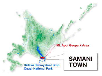
Mt. Apoi Geopark
Mt. Apoi Geopark[1]
Introduction
Samani Town in the eastern Hidaka area of Hokkaido is home to mountains and gorges made of peridotites featuring purity and variety found in few places worldwide as well as endemic alpine plant communities that thrive in the area's particular soil. The town also has a long history and a rich culture based on its development as a trading hub thanks to the favorable natural harbor created by its unusual coastal terrain.
Mt. Apoi Geopark is a geological area where visitors can learn about and enjoy valuable geological heritage and the rich natural environment as well as the history and culture of Samani. It was certified as a Japanese Geopark in 2008, and it has been designated as a UNESCO Global Geopark since 2015. Efforts are made to provide increased opportunities for people to learn about and enjoy Mt. Apoi Geopark via related information and various events.
Theme A: Learning about and enjoying the earth's transformation from peridotites
Mt. Apoi provides opportunities to view, come into contact with and experience this unknown world because the mountain consists of peridotite - the chief component of the earth's upper mantle. Part of the upper mantle deep under the earth's surface is considered to have been thrust up onto the earth's surface by global-scale ground movement to form Mt. Apoi. The mountain thus represents part of the area's valuable geological heritage and provides insights into the nature of the earth's interior. It also gives visitors the opportunity to sense the dynamic activity that the earth has undergone over hundreds of millions of years.
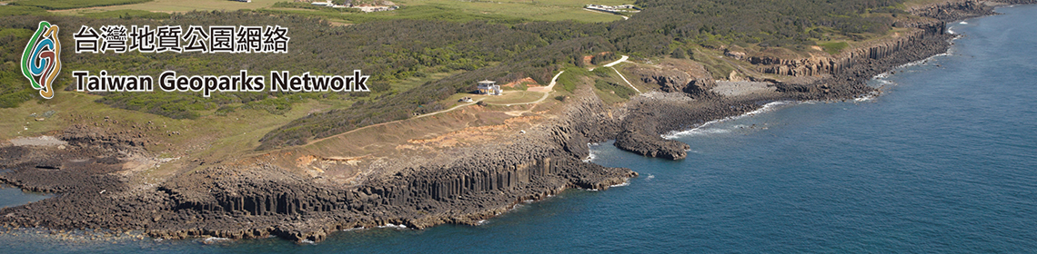
The Hidaka Mountains formed as a result of a collision between two continental plates 13 million years ago. At that time, part of the mantle under the crust was thrust up onto the earth's surface to form the Horoman peridotite complex, which includes Mt. Apoi. The relatively fresh peridotites on and around the mountain contain valuable information from deep inside the earth's mantle, making them the subject of global attention. Mt. Apoi Geopark provides a variety of opportunities to learn about and enjoy phenomena relating to the earth's transformation. These include its status as the site of a plate collision, oddly shaped masses made of cooled and solidified magma, and rocks from far-off southern seas.
Theme B: Learning about and enjoying the natural environment from Mt. Apoi's alpine plants
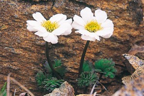
Despite its low altitude, Mt. Apoi provides habitats for alpine vegetation due to its unique soil, weather and geographical conditions. Hidakaso (Callianthemum miyabeanum) and a host of other endemic species grow here, and the area's alpine plant communities have been collectively designated as a Special Natural Monument of Japan. In addition to alpine plants, the area is also home to the endemic Apoimaimai snail (Paraegista apoiensis) and Himechamadaraseseri (Pyrgus malvae; a butterfly not found anywhere else in Japan), as well as the Japanese pika (a relict species from the Ice Age). Mt. Apoi Geopark's valuable and diverse ecosystem provides opportunities to learn about and enjoy the natural environment.
Theme C: Learning about and enjoying the symbiosis between humans and nature from history
The beautiful scenery of oddly shaped rocks (including masses called Oyako-iwa, Sobira-iwa and Cape Enrumu) along the Samani coast is a highlight of Hidaka's coastal road. Legends handed down by indigenous Ainu people in Samani, where Mt. Apoi Geopark is located, often feature these rocks. Cape Enrumu has long been known as a favorable natural harbor thanks to an ideal landform that shelters ships from strong winds, helping Samani to prosper as an important trading hub for Kitamaebune merchant vessels from the Edo period (1603 - 1868) onward. The rich history of people living with Mt. Apoi and the sea continues to the present day in Mt. Apoi Geopark, making it an ideal place to learn about and enjoy the symbiosis between humans and nature.
Geosites
Area A: Horomankyo Area
A1 Power Station No. 2
A2 River beach near the quarry
A3 Japanese White Pine Monument
A4 Fudo-no-sawa
A5 Dam of Power Station No. 2
A6 Horoman-gawa Inari Shrine
A7 Horoman Dam (dam of Power Station No. 3)
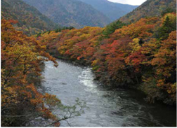
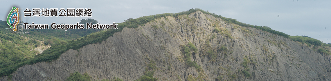
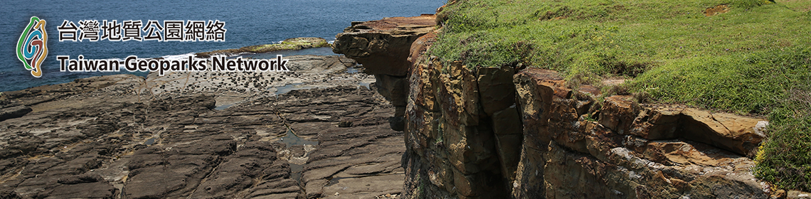
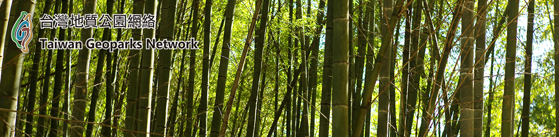
The Horomankyo Gorge, which is made up of peridotites, stretches approximately 8 km to the east of Mt. Apoi where unspoiled mixed coniferous and broad-leaved forests extend along the mountainside. In particular, the predominant spread of Kitagoyo (P. parviflora var. pentaphylla) trees here at the northern limit of their habitat creates unique scenery that led to the area's designation as a Natural Monument of Japan in 1943. Locally known as a favorable late-October autumn foliage spot. The area is also home to hydroelectric power facilities that paved the way for the development of electricity sources in the Hidaka region in the early years of the Showa period (1926 - 1989), thus creating an air of industrial heritage. Although the forest road here is narrow and unpaved, the presence of evacuation spaces at key points allows vehicular passage.
The Horomankyo Gorge, which is located within the 10-km2 area of the Horoman peridotite complex, provides insights into the world of the earth's deep mantle. The area is dotted with geo-sites that allow researchers to observe various types of peridotite.
The Horomankyo Gorge, which is located within the 10-km2 area of the Horoman peridotite complex, provides insights into the world of the earth's deep mantle. The area is dotted with geo-sites that allow researchers to observe various types of peridotite.
Area B Mt. Apoi Area
B1 Rest Spot No. 4
B2 Alpine Plant Restoration Test Site
B3 Fifth-stage mountain lodge
B4 Sixth to seventh stages
B5 Umanose flower fields
B6 Mt. Apoi
B7 The previous horoman flower fields
B8 Apoi to Yoshida
B9 Mt. Yoshida
B10 Mt. Pinneshiri
Mt. Apoi is relatively easy to climb because no heavy gear is required. However, climbers need a certain level of fitness to negotiate the 700-m medium-gradient approach to the trailhead, which is at an elevation of 80 meters about a kilometer inland.
After the trailhead is a stretch of mixed coniferous and broad-leaved forests that are home to a variety of herbaceous plants. Near the fifth-stage mountain lodge is the forest limit, where a dwarf stone pine zone extends over rugged peridotite ground. Colorful alpine plants also begin to stand out in this area. The trail here provides panoramic views of the Pacific Ocean on a clear day, and the Umanose area also affords spectacular views of the Hidaka Mountains and other sights.
It takes between 2.5 and 3.5 hours to reach the summit, and 4.5 to 6 hours for the round trip. Mt. Apoi - a rich habitat for flowers - is made up of peridotites from deep in the earth's mantle. Climbers flock there year after year to enjoy its precious natural environment.
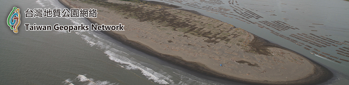
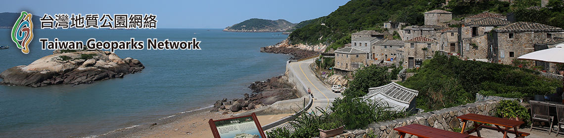
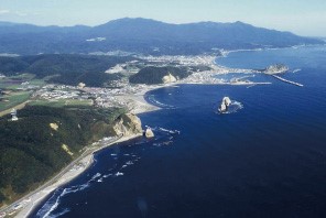
Cape Enrumu on the coast east of Samani Fishing Port is an island connected to the mainland by a sandbar. The 1799 establishment of the Samani Kaisho outpost office by the Edo shogunate at the base of Cape Enrumu provided significant support for Samani's development. The observation platform here is an ideal spot from which to view Mt. Apoi Geopark.
Located at the southern end of the Hidaka Mountains along with National Route 336 (also known as the Golden Road) in Erimo Town, this area used to be notoriously difficult to pass. The Samani Mountain Path was built on the cliffs around 200 years ago to facilitate passage, and is now used as a footpath. At the bottom of the cliffs, high-quality Hidaka Kombu kelp (also known as Mitsuishi Kombu or Laminaria angustata Kjellman) grows on nutrients from the region's peridotite. Surf boats harvesting kelp and locals sun-drying the crop are typical summer scenes in this area.
After the trailhead is a stretch of mixed coniferous and broad-leaved forests that are home to a variety of herbaceous plants. Near the fifth-stage mountain lodge is the forest limit, where a dwarf stone pine zone extends over rugged peridotite ground. Colorful alpine plants also begin to stand out in this area. The trail here provides panoramic views of the Pacific Ocean on a clear day, and the Umanose area also affords spectacular views of the Hidaka Mountains and other sights.
It takes between 2.5 and 3.5 hours to reach the summit, and 4.5 to 6 hours for the round trip. Mt. Apoi - a rich habitat for flowers - is made up of peridotites from deep in the earth's mantle. Climbers flock there year after year to enjoy its precious natural environment.
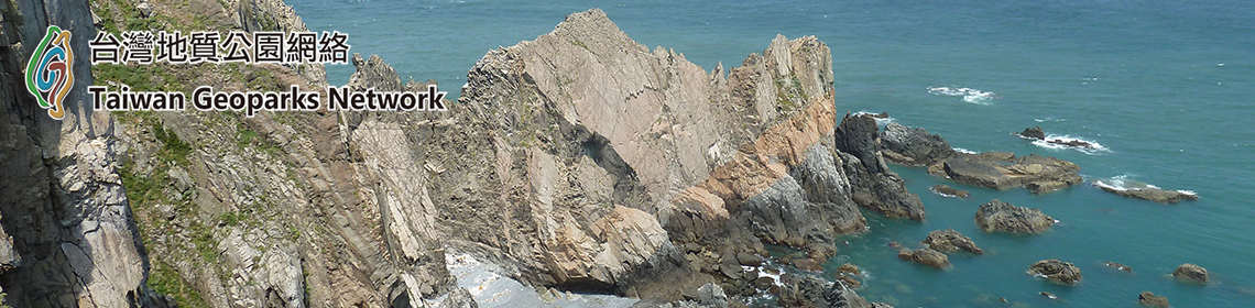
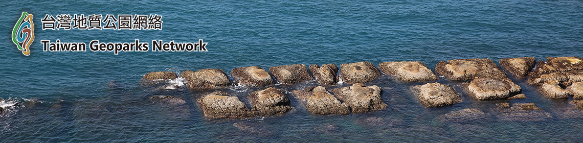
Area C Samani Coast Area
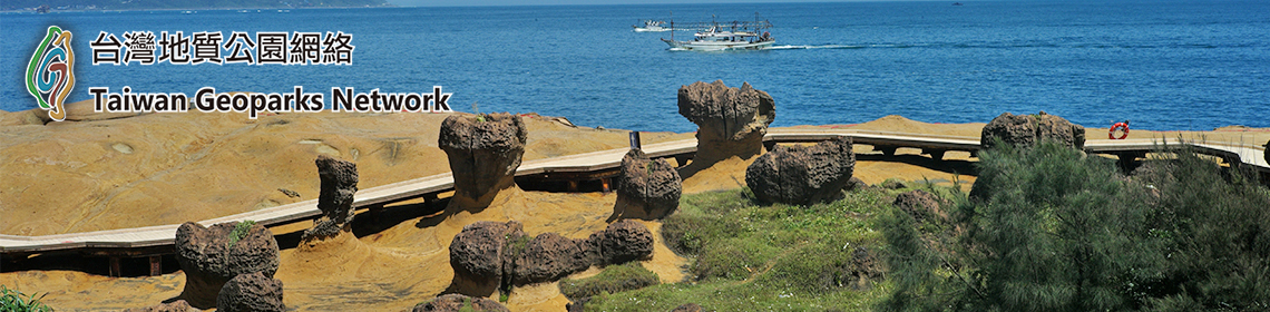
C1 Shiogama Tunnel and Rosoku-iwa
C2 Oyako-iwa and Sobira-iwa
C3 Cape Enrumu
C4 Mt. Kannon
C5 Tojuin Temple
C6 Byobu Cliff in Hirau
C7 Old quarry behind Samani Elementary School
C8 Okada District cise (traditional Ainu dwelling)
In contrast to the geology of the towering Apoi Mountains, the area to their west is characterized by gently sloping terrain, with Samani Town center located on the coastline. Along with the Apoi Mountains, rocky peaks of varying sizes flanking the sea characterize the region's landscape. The unique scenery here is associated with numerous legends of the Ainu people, who have lived in harmony with the natural environment for hundreds of years. One of these rocky mountains is Mt. Kannon, thought to have previously been the site of a chashi (fort). With a height of only 100 meters or so, this peak overlooks Samani Fishing Port and has an observatory that affords sweeping views of rock formations in the sea as well as Mt. Apoi and other local icons.Cape Enrumu on the coast east of Samani Fishing Port is an island connected to the mainland by a sandbar. The 1799 establishment of the Samani Kaisho outpost office by the Edo shogunate at the base of Cape Enrumu provided significant support for Samani's development. The observation platform here is an ideal spot from which to view Mt. Apoi Geopark.
Area D Hidaka Yabakei Area
D1 Ana-iwa in Fuyushima
D2 Fault at the Higashi Fuyushima Tunnel
D3 Metagabbro at the Kotoni Tunnel
D4 Granite at the Taisho Tunnel
D5 Geological fold at the Ruranbetsu Tunnel
D6 Samani Mountain Path and Wasuke Jizo
Hidaka Yabakei is a 7-km stretch of precipitous cliffs along the coast of the Pacific Ocean, into which the foot of Mt. Apoi plunges. It is believed to mark the place where the Eurasian Plate and the North American Plate once collided. Part of the boundary (the Hidaka Main Thrust) between the plates remains in this area.Located at the southern end of the Hidaka Mountains along with National Route 336 (also known as the Golden Road) in Erimo Town, this area used to be notoriously difficult to pass. The Samani Mountain Path was built on the cliffs around 200 years ago to facilitate passage, and is now used as a footpath. At the bottom of the cliffs, high-quality Hidaka Kombu kelp (also known as Mitsuishi Kombu or Laminaria angustata Kjellman) grows on nutrients from the region's peridotite. Surf boats harvesting kelp and locals sun-drying the crop are typical summer scenes in this area.
Area E Shintomi Area
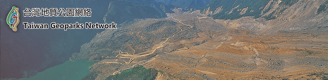
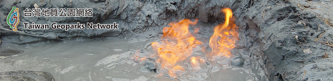
E1 Old mine of Ono Kogyo Co., Ltd.
E2 Lenticular sandstone at the Samani Dam
E3 Chert in Shintomi
E4 Limestone blocks in Matsuokazawa
The Japanese archipelago is an aggregation of accretionary prisms. These are formed from the surface layer of an oceanic plate that is scraped off and accreted onto a continental plate when the two collide and the former subducts beneath the latter in a trench on the ocean floor. Sandstone and mudstone or sediment from the overriding plate as well as limestone, chert and basalt from southern seas thousands of kilometers away are mixed and undergo deformation, forming a rough aggregate of different rocks known as a mélange.
Limestone is distributed extensively in and around the Shintomi Area, and has long been mined there. This rock is also known to derive from accretionary prisms because outcrops in the area have a typical mélange structure without continuous bedding.
Samani’s overview
Samani Town spreads out to the sparkling blue Pacific Ocean with Mt. Apoi and the Hidaka Mountains in the background. The town's main industries are fisheries, agriculture and livestock farming, which have thrived thanks to the area's temperate oceanic climate and its vast tracts of fertile ground. Samani has a rich history and tradition, and its magnificent mountains and coastline with oddly shaped rocks and cliffs create beautiful views that change with the seasons. The town's name derives from the Ainu language, but its exact etymology is unknown. One published history of Samani Town states that the name may originate from the term samau-ni (withering trees) or esaman-pet (otter river).
Bounties of the sea
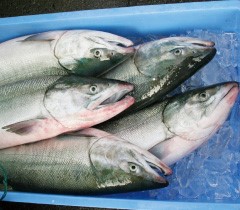
Salmon
Samani has a long history of fisheries as a main local industry. Kombu kelp and salmon have been important products for the area since the Edo period (1603 - 1868). The waters off Samani are home to rich fishing grounds where the warm Kuroshio current meets the cold Oyashio current, yielding a variety of seafood including salmon, Alaska Pollack and squid. Salted salmon processed by local fishermen using a traditional preservation method has enjoyed rising popularity recently. Sashimi made from the Samani specialty of whelks (neptunea polycostata) is exquisite and every bit as delicious as the similar but more highly prized abalone. The Samani coast is known for its high-quality Mitsuishi Kombu kelp (Laminaria angustata). Kelp can typically be seen drying all over the town on clear summer days, and is shipped nationwide under the commercial name of Hidaka Kombu.
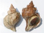
Whelks
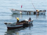
Kombu kelp harvesting
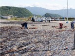
Kombu kelp drying

Hidaka Kombu kelp ready for shipment
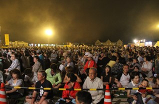
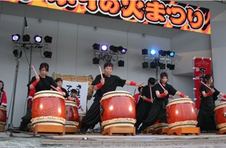
Apoi Fire Festival
The name Apoi derives from a tale in which Ainu people made a large fire at a mountaintop altar as if to burn the sky and prayed to a kamuy (god) for success in their hunting of deer (part of the Ainu diet). To re-enact this legend, the Apoi Fire Festival - Samani's largest event - is held on the first weekend of every August. The festival begins with a solemn lighting ceremony at the foot of the mountain and continues with a variety of events, including the lighting of a bonfire in the shape of the Chinese character for fire on Cape Enrumu, an Apoi drum performance, and the Nebuta Parade (a procession of gigantic lanterns).
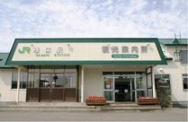
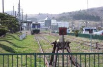
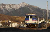
Terminal station
The 146.5-km JR Hidaka Main Line extends southeastward along the Pacific Ocean from Tomakomai. Its unique blue and white KiHa 40-series rolling stock is popular with railway enthusiasts. The line is known for its scenic views, which include vast expanses of the Pacific Ocean, thoroughbreds grazing at leisure in fields, and the Hidaka Mountains. Samani Station is the terminus of the Hidaka Main Line as shown by the car stop at the end of the platform. Buses to Cape Erimo also leave from the station, making it both a terminus and a starting point for new trips.
Sunset
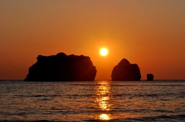
Photograph: Yasuhiro Narita
The Oyako-iwa Rocks rising from the Pacific are a symbol of Samani. The area is popular with beachgoers in summer, but has a different appearance in winter with spectacular sunset views. As the sun goes down behind the rocks during the cold season, rays of light shine through the gaps between them onto the sea against a crimson sky, creating a truly awesome sight. The Oyako-iwa (meaning "parent-and-child rocks") are the subject of an Ainu legend about the strong bond between parents and children. Making a wish here during sunset is said to bring family happiness.
[1] http://www.apoi-geopark.jp/english/