

View count:
1687
News
Off the Beaten Track: Caoling after 921[1]
By Richard Saunders / Contributing reporterFri, Jun 09, 2017 - Page 13
Website: Taipei News
The mountain resort of Caoling (草嶺) in Yunlin County is a survivor. Not only did it quickly recover after the area was one of the worst-hit during the great devastating 921 Earthquake in 1999, but it also managed to make a huge tourist draw out of the beautiful lake that temporarily formed when a huge earthquake-triggered landslide dammed the river below the village. The resort also bounced back after receiving a severe beating during Typhoon Morakot in August 2009.
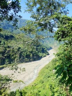
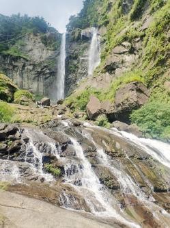
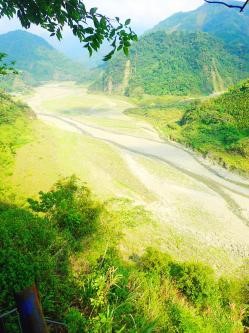
| The beautiful gorge below Caoling village. | The 40-meter high Penglai Waterfall. |
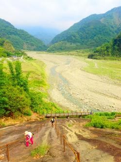
| The view over the valley of the Clearwater River, from the Great Steep Wall. | The valley of the Clearwater River. |
For a stunning introduction to just how much damage the 921 Earthquake caused 18 years ago, turn off route 149 (which, by the way, is one of the most beautiful mountain roads in this region of Taiwan) into the upper of the two streets that comprise the tiny village, marked by a large stone plaque and the words “Caoling Geopark” in English. Pass a string of small hotels and homestays, and the road meanders around the wooded mountainside to a signposted junction.
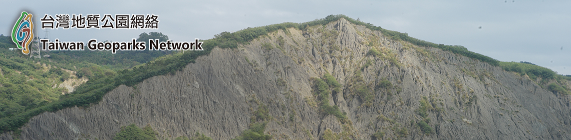
Turn right here along a rather bumpy track (passable by car) to the Yulin Caoling Geopark (雲林草嶺地質公園), about two kilometers west of Caoling. The geopark lies below what was once the summit of Caoling Mountain, originally over 1,200 meters in height, which lost its top third in a vast landslide. It’s a less dramatic sight nowadays than it was immediately following the temblor, since the intervening years have substantially softened the devastated landscape as plants regrow and cover the bare earth, but the enormity of the landslide is still pretty clear. Info plaques (some in English) provide some fascinating information. The lunar landscape in front, ground flat by thousands of tons of falling rock and earth, now covers two of Caoling’s traditional “10 sights.” Sadly gone forever is the wonderful Lost Soul Valley (斷魂谷), a strange, hidden little gorge bounded by rugged cliffs, down which several waterfalls plunged during the rainy season. Both this and the former Spring and Autumn Cliffs (斷崖春秋), which loomed above the road that once led out to the valley, were actually produced by an earlier, 7.1 magnitude earthquake, that struck the area in 1941. However, while causing vast destruction and loss of life, the 1999 earthquake did, likewise, create a couple of striking new features in the Caoling area, which Taiwanese bloggers have lost no time in naming the New Spring and Autumn Cliffs (新斷崖春秋), and the New Lost Soul Valley (新斷魂谷).
Keep straight ahead at the junction (signposted “Lakeshore Sidewalk”) and the first turning on the left a few meters further goes down to a parking lot, where a surfaced path provides a useful short cut to the Enchanted Valley and Water Curtain Cave (described in last week’s column). The road ahead winds downhill towards the Clearwater River (清水溪) far below, and one branch ends with a fine view of the landslide site and the impressive New Spring and Autumn Cliffs.
The remainder of Caoling’s sights to survive that terrible night in September 1999 are also well worth visiting if you have the time. Top of the pile is Penglai Waterfall (蓬萊瀑布), clearly signposted two kilometers northeast of the village. It’s perhaps the most impressive single attraction at Caoling, at least during the rainy season (summer and early autumn), plunging 40 meters in twin spouts of great power. Naturally it’s at its mightiest when in full voice, especially shortly after a typhoon. Look out for the wires belonging to a rustic cable car that was still taking visitors to the head of the waterfall on my first visit here back in 1993. It’s long since been abandoned and left to rust.
A short drive (also signposted) from route 149 is the start of the short walk along the Clearwater River to the Great Steep Wall (峭壁雄風), a large, sloping rock face that rises above the river at an angle of up to 45 degrees, and can be climbed with the aid of fixed ropes. It’s especially popular with kids, and there are magnificent views from its upper reaches over the gorge.
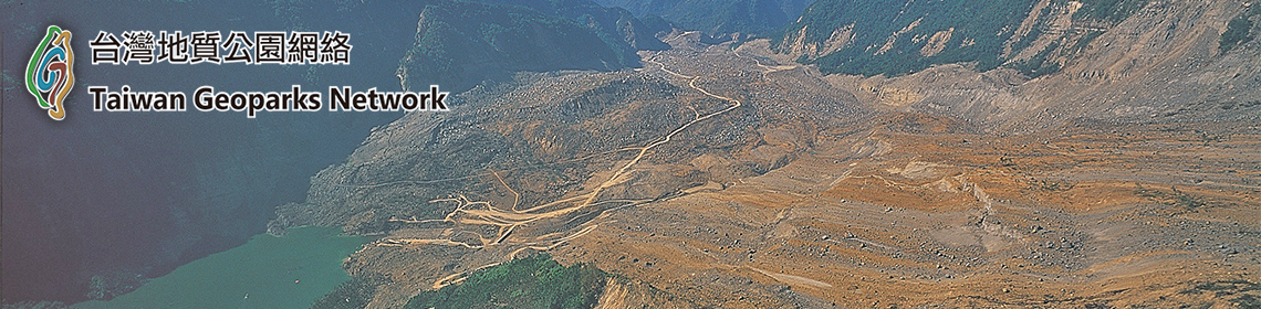
The remaining two of Caoling’s “traditional” 10 sights lie just off route 149 several kilometers to the north of the village, near the tiny settlement of Neihu (內湖). After passing through the lengthy Caoling Tunnel, the road winds down through a devastating landslide, a dramatic reminder of the damage wrought upon this area by Typhoon Morakot. Pull into a coach and car park on the left just before the road crosses a bridge, and a path here follows the stream down past a series of small, naturally eroded pools in the flat bedrock known as the Chain of Pearls (連珠池). Beyond them is a bridge which spans the stream immediately before it plunges over Tongxin Waterfall (同心瀑布), unseen below. The trail that descended to the foot of the falls on my first visit is long gone, and nowadays the only way to see the impressive cataract properly is by a scenic river trace upstream from below. That, however, is a serious proposition; most visitors will be satisfied with standing on the bridge and peering at the water as it disappears over the abyss below.
[1] Link: http://www.taipeitimes.com/News/feat/archives/2017/06/09/2003672193