View count:
3895
Location
The location of this Geopark reflects in its name. Located in the Southwest coast of Taiwan, the Geopark starts from Jiuhuwei River in Yunlin County to the north, extends to Yanshui River in Tainan City to the south, borders to the east at Provincial Highway Tai 17 (not including Tainan Technology Industrial Park, including the dormitories of Southern Japanese Salt Corporation of Budai Township, Chiayi County and Nankunshen Urban Plan of Beimen District, Tainan City) and borders to the west at the contour of 20m below sea-level (not including the sea zone north of Waisanding Sand bar). Its total land area is 87,802 hectares with land area being 37,166 hectares and sea area being 50,6363 hectares. The administrative region includes 8 township and districts, namely Sihu and Kouhu in Yunlin; Dongshi and Budai in Chiayi; Beimen, Jiangjun, Qigu and Annan District in Tainan. Being the longest and largest Geopark in Taiwan, the Southwest coat Geopark has diverse characteristics from North to South. In total, there are 14 geosites from North to South respectively being: Waisanding Sand Bar, Aogu Wetlands, Haomailiao Nature Reserve and Budai Wetlands which are located in Chiayi County; Beimen lagoon, Fan-shaped salt fields, Qingshangang Barrier, Cigu Salt Mountain, Dingtoue Barrier, Cigu lagoon, Wangziliao Barrier, Black-faced Spoonbill Conservation, Zengwun Estuary Wetland, Sihcao Wetland which are located in Tainan.
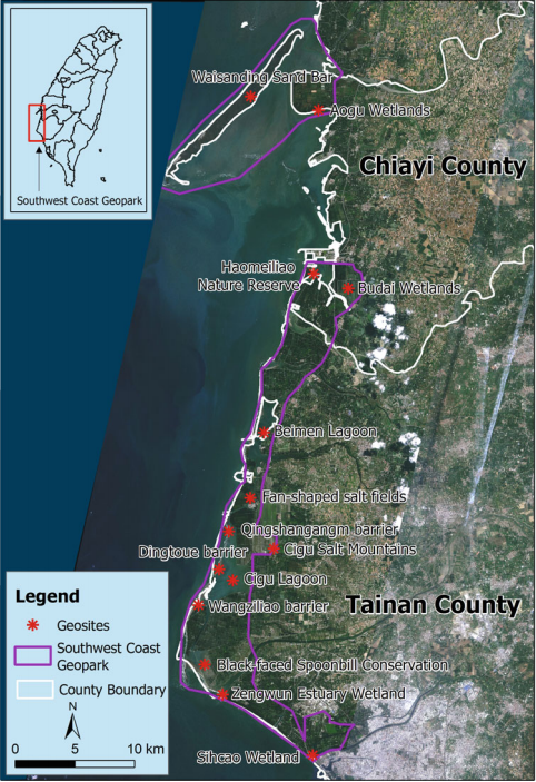
Location map of Southwest Coastal Geopark
Source: Lin, J. C., Su, S. C. (2019). Geoparks of Taiwan. Their development and Prospects for a Sustainable Future